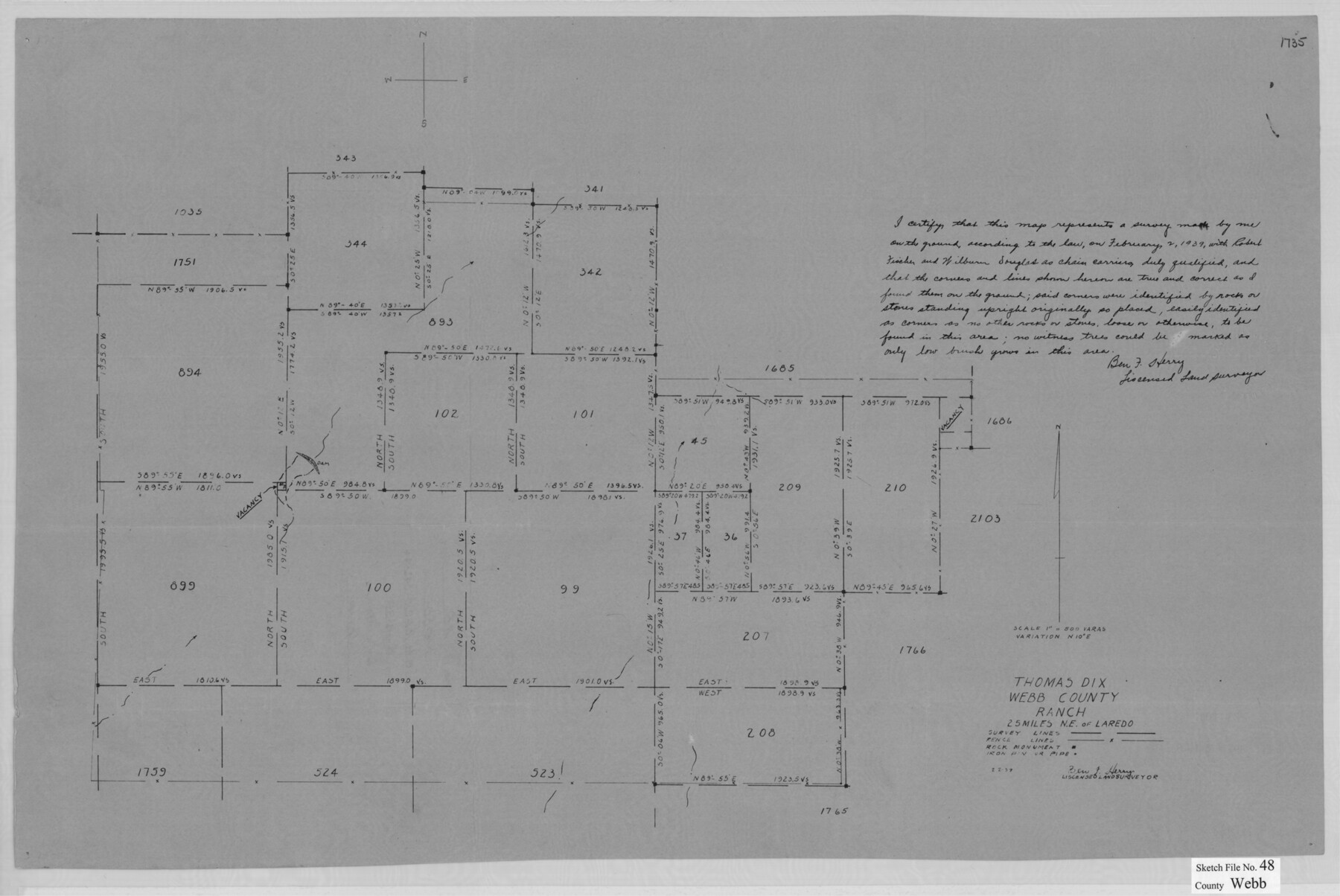
Webb County Sketch File 48
Thomas Dix, Webb County Ranch northeast from Laredo
-
Map/Doc
12646
-
Collection
General Map Collection
-
Object Dates
2/2/1939 (Creation Date)
4/14/1939 (File Date)
-
People and Organizations
Ben F. Herry (Surveyor/Engineer)
-
Counties
Webb
-
Subjects
Surveying Sketch File
-
Height x Width
17.9 x 26.7 inches
45.5 x 67.8 cm
-
Medium
blueprint/diazo
-
Scale
1" = 500 varas
-
Features
Contreras Ranch
Proposed State Highway [to Sendero]
Gato Creek
Burro Tank
Part of: General Map Collection
Webb County Rolled Sketch 49

Print $40.00
- Digital $50.00
Webb County Rolled Sketch 49
1943
Size 55.4 x 13.1 inches
Map/Doc 10124
Mississippi River to Galveston

Print $40.00
- Digital $50.00
Mississippi River to Galveston
1986
Size 36.8 x 49.9 inches
Map/Doc 69948
Controlled Mosaic by Jack Amman Photogrammetric Engineers, Inc - Sheet 23

Print $20.00
- Digital $50.00
Controlled Mosaic by Jack Amman Photogrammetric Engineers, Inc - Sheet 23
1954
Size 20.0 x 24.0 inches
Map/Doc 83473
Flight Mission No. CGI-3N, Frame 52, Cameron County

Print $20.00
- Digital $50.00
Flight Mission No. CGI-3N, Frame 52, Cameron County
1954
Size 18.7 x 22.2 inches
Map/Doc 84558
Dallas County Boundary File 2

Print $10.00
- Digital $50.00
Dallas County Boundary File 2
Size 11.2 x 8.4 inches
Map/Doc 52115
Hood County Working Sketch 10

Print $20.00
- Digital $50.00
Hood County Working Sketch 10
1974
Size 26.7 x 35.6 inches
Map/Doc 66204
Flight Mission No. DIX-5P, Frame 139, Aransas County

Print $20.00
- Digital $50.00
Flight Mission No. DIX-5P, Frame 139, Aransas County
1956
Size 17.6 x 17.8 inches
Map/Doc 83800
Outer Continental Shelf Leasing Maps (Louisiana Offshore Operations)

Print $20.00
- Digital $50.00
Outer Continental Shelf Leasing Maps (Louisiana Offshore Operations)
1955
Size 11.1 x 13.3 inches
Map/Doc 76090
Deaf Smith County Sketch File D

Print $20.00
- Digital $50.00
Deaf Smith County Sketch File D
Size 12.6 x 27.7 inches
Map/Doc 11306
Hamilton County Sketch File C

Print $6.00
- Digital $50.00
Hamilton County Sketch File C
Size 12.4 x 11.0 inches
Map/Doc 24950
Flight Mission No. CRC-2R, Frame 55, Chambers County

Print $20.00
- Digital $50.00
Flight Mission No. CRC-2R, Frame 55, Chambers County
1956
Size 18.7 x 22.4 inches
Map/Doc 84728
Limestone County Sketch File 5

Print $44.00
- Digital $50.00
Limestone County Sketch File 5
1848
Size 9.7 x 7.6 inches
Map/Doc 30160
You may also like
Blanco County Sketch File 52

Print $4.00
- Digital $50.00
Blanco County Sketch File 52
Size 11.3 x 8.9 inches
Map/Doc 76332
Lavaca County

Print $40.00
- Digital $50.00
Lavaca County
1946
Size 51.1 x 42.8 inches
Map/Doc 73216
Palo Pinto County Working Sketch 3

Print $20.00
- Digital $50.00
Palo Pinto County Working Sketch 3
1906
Map/Doc 71386
Hockley County Sketch File 7

Print $20.00
- Digital $50.00
Hockley County Sketch File 7
Size 21.0 x 22.5 inches
Map/Doc 11770
Kimble County Working Sketch 32

Print $20.00
- Digital $50.00
Kimble County Working Sketch 32
1944
Size 22.6 x 16.0 inches
Map/Doc 70100
Cooke County Working Sketch 38

Print $40.00
- Digital $50.00
Cooke County Working Sketch 38
1997
Size 48.2 x 36.6 inches
Map/Doc 68275
Hutchinson County Rolled Sketch 44-2

Print $20.00
- Digital $50.00
Hutchinson County Rolled Sketch 44-2
2002
Size 24.0 x 36.0 inches
Map/Doc 77538
Flight Mission No. DIX-7P, Frame 13, Aransas County

Print $20.00
- Digital $50.00
Flight Mission No. DIX-7P, Frame 13, Aransas County
1956
Size 4.0 x 5.0 inches
Map/Doc 83865
Montgomery County Working Sketch 26

Print $20.00
- Digital $50.00
Montgomery County Working Sketch 26
1941
Size 40.8 x 30.7 inches
Map/Doc 71133
Sherman County Rolled Sketch 11

Print $20.00
- Digital $50.00
Sherman County Rolled Sketch 11
Size 34.0 x 35.0 inches
Map/Doc 9930
Hartley County Working Sketch 5

Print $20.00
- Digital $50.00
Hartley County Working Sketch 5
1957
Size 46.3 x 28.9 inches
Map/Doc 66055
Reagan County

Print $20.00
- Digital $50.00
Reagan County
1940
Size 41.6 x 31.4 inches
Map/Doc 77403