Yoakum County Sketch File 19
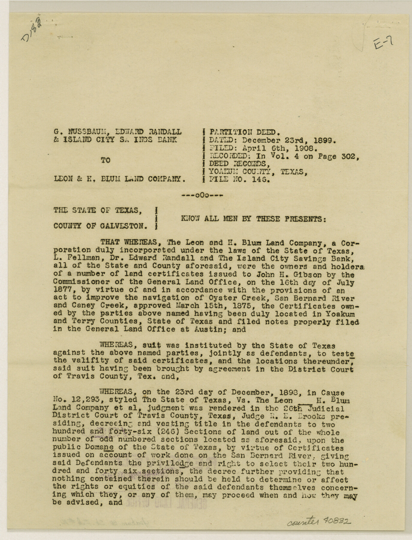
[Partition deed relating to Judgement 12293]
-
Map/Doc
40832
-
Collection
General Map Collection
-
Object Dates
1898/12/23 (Creation Date)
1948/9/28 (File Date)
1898/12/23 (Creation Date)
1908/4/6 (File Date)
1948/9/28 (File Date)
-
Counties
Yoakum
-
Subjects
Surveying Sketch File
-
Height x Width
11.5 x 8.8 inches
29.2 x 22.4 cm
-
Medium
paper, print
-
Features
San Bernard River
Oyster Creek
Caney Creek
Part of: General Map Collection
Val Verde County Working Sketch 91

Print $20.00
- Digital $50.00
Val Verde County Working Sketch 91
1976
Size 46.5 x 42.8 inches
Map/Doc 72226
Sutton County Working Sketch 40

Print $20.00
- Digital $50.00
Sutton County Working Sketch 40
1948
Size 34.9 x 28.3 inches
Map/Doc 62383
Val Verde County Sketch File AA3

Print $20.00
- Digital $50.00
Val Verde County Sketch File AA3
1924
Size 19.5 x 20.6 inches
Map/Doc 12540
Passage par terre a la Californie decouvert par le R.P. Eusebe-Francois Kino Jesuite depuis 1698 jusqua 1701 ou l'on voit encore les nouvelles Missions des PP. de la Compagnie de Texas

Print $20.00
- Digital $50.00
Passage par terre a la Californie decouvert par le R.P. Eusebe-Francois Kino Jesuite depuis 1698 jusqua 1701 ou l'on voit encore les nouvelles Missions des PP. de la Compagnie de Texas
1819
Size 10.7 x 10.6 inches
Map/Doc 96567
Freestone County

Print $20.00
- Digital $50.00
Freestone County
1918
Size 46.8 x 39.8 inches
Map/Doc 4702
Buchanan Dam Reservoir Clearing

Print $20.00
- Digital $50.00
Buchanan Dam Reservoir Clearing
1935
Size 21.8 x 40.4 inches
Map/Doc 60393
Schleicher County Rolled Sketch 7

Print $20.00
- Digital $50.00
Schleicher County Rolled Sketch 7
Size 32.5 x 37.9 inches
Map/Doc 9904
University Land Field Notes for Block 52 in Crockett, Irion, and Schleicher Counties, Blocks 55 and 56 in Crockett and Schleicher Counties, Block 53 in Irion and Schleicher Counties, and Blocks 54 and 57 in Schleicher County

University Land Field Notes for Block 52 in Crockett, Irion, and Schleicher Counties, Blocks 55 and 56 in Crockett and Schleicher Counties, Block 53 in Irion and Schleicher Counties, and Blocks 54 and 57 in Schleicher County
Map/Doc 81719
Travis County

Print $40.00
- Digital $50.00
Travis County
1880
Size 59.4 x 68.7 inches
Map/Doc 16903
Tom Green County Sketch File 63

Print $20.00
- Digital $50.00
Tom Green County Sketch File 63
1890
Size 31.8 x 17.9 inches
Map/Doc 12445
Edwards County Working Sketch 114

Print $20.00
- Digital $50.00
Edwards County Working Sketch 114
1972
Size 33.6 x 33.1 inches
Map/Doc 68990
Brazos River, Washington Sheet

Print $6.00
- Digital $50.00
Brazos River, Washington Sheet
1936
Size 30.4 x 24.7 inches
Map/Doc 65277
You may also like
Pecos County Sketch File 1A

Print $20.00
- Digital $50.00
Pecos County Sketch File 1A
1919
Size 34.3 x 23.7 inches
Map/Doc 12155
Coke County Rolled Sketch 19

Print $20.00
- Digital $50.00
Coke County Rolled Sketch 19
1954
Size 18.5 x 25.8 inches
Map/Doc 5519
[Surveys in Austin's Colony along the Colorado River]
![198, [Surveys in Austin's Colony along the Colorado River], General Map Collection](https://historictexasmaps.com/wmedia_w700/maps/198.tif.jpg)
Print $20.00
- Digital $50.00
[Surveys in Austin's Colony along the Colorado River]
1830
Size 38.9 x 23.2 inches
Map/Doc 198
[Sketch for Mineral Application 33721 - 33725 Incl. - Padre and Mustang Island]
![2868, [Sketch for Mineral Application 33721 - 33725 Incl. - Padre and Mustang Island], General Map Collection](https://historictexasmaps.com/wmedia_w700/maps/2868.tif.jpg)
Print $20.00
- Digital $50.00
[Sketch for Mineral Application 33721 - 33725 Incl. - Padre and Mustang Island]
1942
Size 29.7 x 22.3 inches
Map/Doc 2868
Presidio County Rolled Sketch 83B

Print $20.00
- Digital $50.00
Presidio County Rolled Sketch 83B
Size 16.6 x 23.0 inches
Map/Doc 2061
Stephens County Sketch File 3

Print $4.00
- Digital $50.00
Stephens County Sketch File 3
Size 8.6 x 10.6 inches
Map/Doc 37015
W. W. Boatright Subdivision of 5 Acres out of North Half of Survey Number 1, Block Number 36, Township 5 North. Dawson County, Texas

Print $20.00
- Digital $50.00
W. W. Boatright Subdivision of 5 Acres out of North Half of Survey Number 1, Block Number 36, Township 5 North. Dawson County, Texas
1924
Size 18.8 x 24.6 inches
Map/Doc 92590
Right of Way and Track Map - Houston & Texas Central R.R. operated by the T. and N. O. R.R. Co. - Main Line

Print $40.00
- Digital $50.00
Right of Way and Track Map - Houston & Texas Central R.R. operated by the T. and N. O. R.R. Co. - Main Line
1918
Size 26.0 x 58.1 inches
Map/Doc 82856
Zavala County Rolled Sketch 33

Print $20.00
- Digital $50.00
Zavala County Rolled Sketch 33
Size 19.3 x 26.9 inches
Map/Doc 8334
Lee County Working Sketch 8

Print $20.00
- Digital $50.00
Lee County Working Sketch 8
1979
Size 27.8 x 37.1 inches
Map/Doc 70387
Map of Jasper County

Print $40.00
- Digital $50.00
Map of Jasper County
1898
Size 48.6 x 39.2 inches
Map/Doc 4990
Webb County Boundary File 1a

Print $50.00
- Digital $50.00
Webb County Boundary File 1a
Size 14.3 x 9.0 inches
Map/Doc 59703