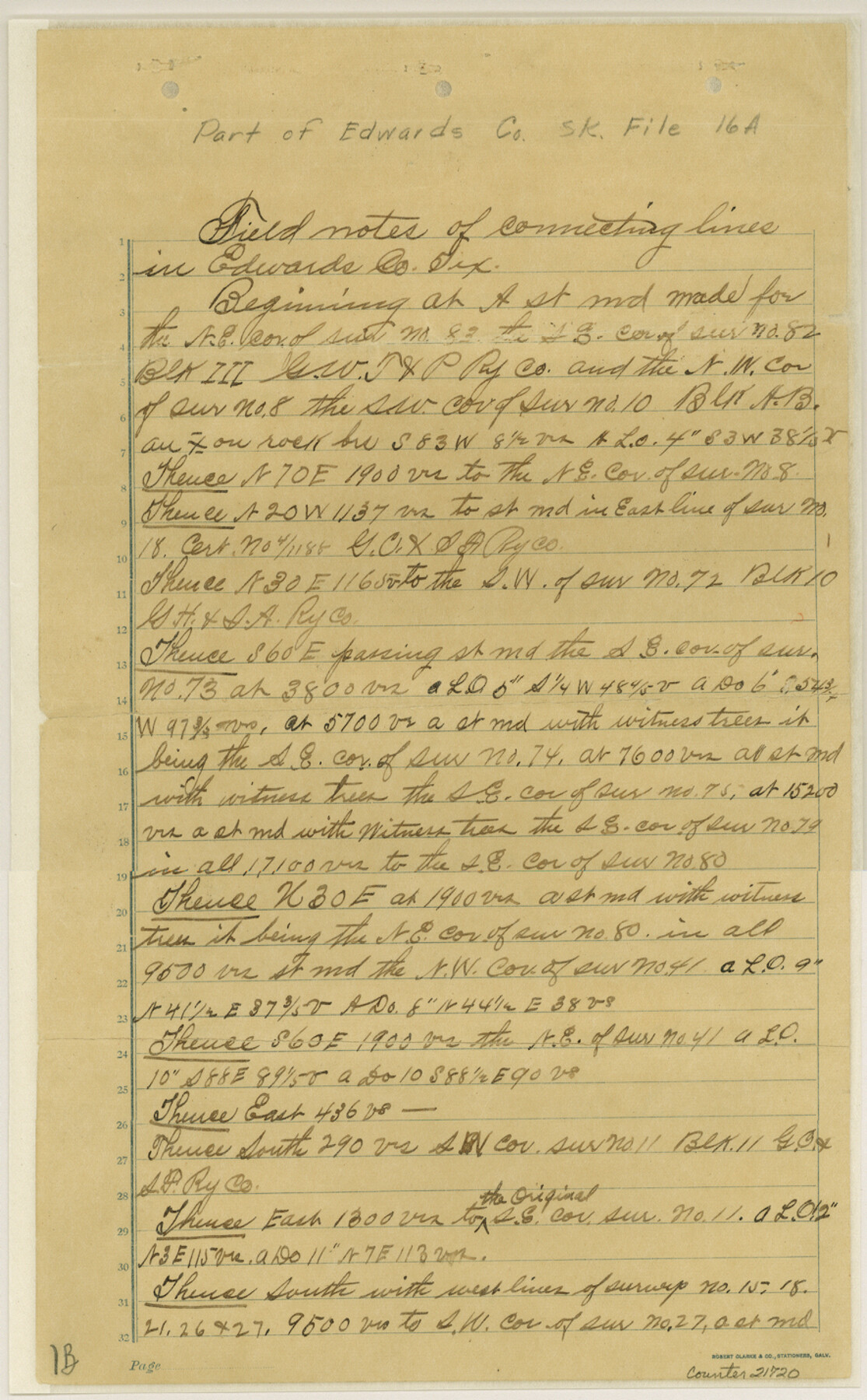
Edwards County Sketch File 16a
S. W. of Rock Springs
-
Map/Doc
21720
-
Collection
General Map Collection
-
Object Dates
1903/7/18 (Creation Date)
1903/7/25 (File Date)
1903 (Survey Date)
-
People and Organizations
J.L. Hunter (Surveyor/Engineer)
-
Counties
Edwards
-
Subjects
Surveying Sketch File
-
Height x Width
14.3 x 8.8 inches
36.3 x 22.4 cm
-
Medium
paper, manuscript
-
Features
Hackberry Creek
Indian Creek
Part of: General Map Collection
Schleicher County Sketch File 37

Print $20.00
- Digital $50.00
Schleicher County Sketch File 37
1952
Size 24.9 x 29.3 inches
Map/Doc 12310

Blanco County Working Sketch 29

Print $40.00
- Digital $50.00
Blanco County Working Sketch 29
1969
Size 52.4 x 33.4 inches
Map/Doc 67389
Gregg County Working Sketch 8

Print $20.00
- Digital $50.00
Gregg County Working Sketch 8
1936
Size 26.0 x 23.3 inches
Map/Doc 63274
Cameron County State Real Property Sketch 1

Print $20.00
- Digital $50.00
Cameron County State Real Property Sketch 1
1996
Size 25.1 x 38.9 inches
Map/Doc 80130
Armstrong County Sketch File 3

Print $40.00
- Digital $50.00
Armstrong County Sketch File 3
1883
Size 27.4 x 29.4 inches
Map/Doc 10839
Castro County Working Sketch Graphic Index

Print $20.00
- Digital $50.00
Castro County Working Sketch Graphic Index
1932
Size 43.1 x 38.2 inches
Map/Doc 76490
Bexar County State Real Property Sketch 6

Print $20.00
Bexar County State Real Property Sketch 6
2006
Size 22.2 x 33.1 inches
Map/Doc 96980
Wichita County Sketch File 34

Print $6.00
- Digital $50.00
Wichita County Sketch File 34
1949
Size 14.4 x 8.8 inches
Map/Doc 40154
Galveston County

Print $40.00
- Digital $50.00
Galveston County
1939
Size 45.0 x 57.6 inches
Map/Doc 1835
Flight Mission No. DQO-6K, Frame 33, Galveston County

Print $20.00
- Digital $50.00
Flight Mission No. DQO-6K, Frame 33, Galveston County
1952
Size 18.8 x 22.4 inches
Map/Doc 85099
Nueces County Sketch File 59

Print $23.00
- Digital $50.00
Nueces County Sketch File 59
1989
Size 11.2 x 8.6 inches
Map/Doc 32951
You may also like
Galveston County NRC Article 33.136 Sketch 40

Print $22.00
- Digital $50.00
Galveston County NRC Article 33.136 Sketch 40
2005
Size 23.9 x 36.5 inches
Map/Doc 83061
Webb County Working Sketch 55

Print $40.00
- Digital $50.00
Webb County Working Sketch 55
1955
Size 15.9 x 53.2 inches
Map/Doc 72421
National Map Company's Map of Texas showing counties, cities, towns, villages and post offices, steam and electric railways with stations and distance between stations

Print $40.00
- Digital $50.00
National Map Company's Map of Texas showing counties, cities, towns, villages and post offices, steam and electric railways with stations and distance between stations
1920
Size 50.3 x 51.1 inches
Map/Doc 10749
Stonewall County Rolled Sketch 15

Print $20.00
- Digital $50.00
Stonewall County Rolled Sketch 15
1902
Size 39.2 x 28.0 inches
Map/Doc 7870
[Gulf, Colorado & Santa Fe Railway Company]
![64410, [Gulf, Colorado & Santa Fe Railway Company], General Map Collection](https://historictexasmaps.com/wmedia_w700/maps/64410.tif.jpg)
Print $40.00
- Digital $50.00
[Gulf, Colorado & Santa Fe Railway Company]
1893
Size 21.5 x 121.2 inches
Map/Doc 64410
Austin County Sketch File 4a

Print $8.00
- Digital $50.00
Austin County Sketch File 4a
1881
Size 6.5 x 4.9 inches
Map/Doc 13861
[County Line between Dickens and Kent Counties]
![90938, [County Line between Dickens and Kent Counties], Twichell Survey Records](https://historictexasmaps.com/wmedia_w700/maps/90938-1.tif.jpg)
Print $20.00
- Digital $50.00
[County Line between Dickens and Kent Counties]
1891
Size 42.4 x 7.4 inches
Map/Doc 90938
Survey of the Mexican Lines of Defence at Cerro Gordo, and the lines of attack of the American Army under Major General Scott, on the 17th and 18th of April, 1847

Print $20.00
- Digital $50.00
Survey of the Mexican Lines of Defence at Cerro Gordo, and the lines of attack of the American Army under Major General Scott, on the 17th and 18th of April, 1847
1847
Size 15.3 x 21.6 inches
Map/Doc 95830
Brewster County Sketch File 18

Print $8.00
- Digital $50.00
Brewster County Sketch File 18
1942
Size 13.8 x 7.6 inches
Map/Doc 15813
Tom Green County Sketch File 82

Print $20.00
- Digital $50.00
Tom Green County Sketch File 82
1888
Size 18.5 x 20.9 inches
Map/Doc 12454
Howard County Rolled Sketch 12A

Print $20.00
- Digital $50.00
Howard County Rolled Sketch 12A
1948
Size 23.3 x 13.9 inches
Map/Doc 6244
Taylor County Boundary File 1

Print $44.00
- Digital $50.00
Taylor County Boundary File 1
Size 8.4 x 8.2 inches
Map/Doc 59184