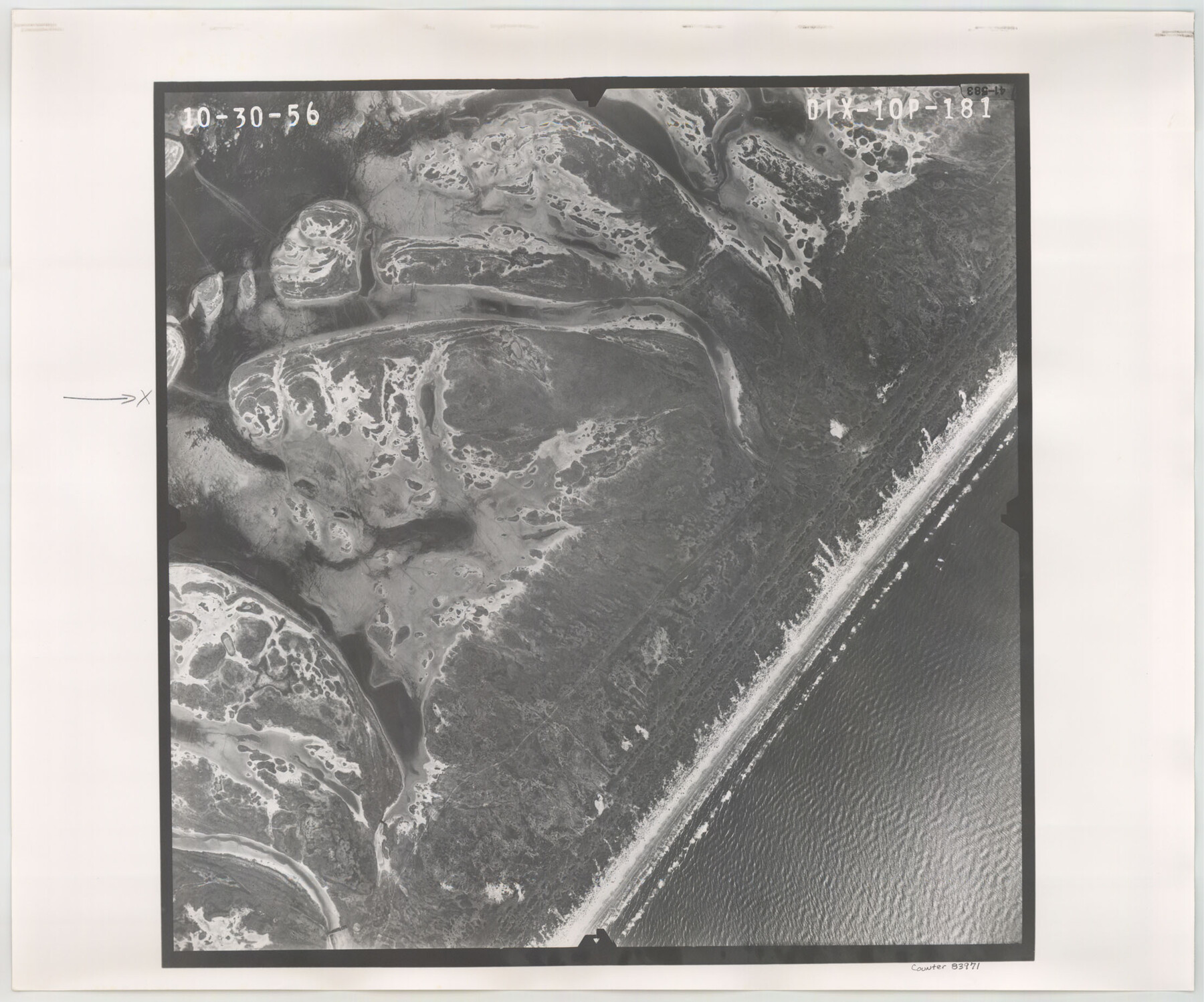
Flight Mission No. DIX-10P, Frame 181, Aransas County
DIX-10P-181
-
Map/Doc
83971
-
Collection
General Map Collection
-
Object Dates
1956/10/30 (Creation Date)
-
People and Organizations
U. S. Department of Agriculture (Publisher)
-
Counties
Aransas
-
Subjects
Aerial Photograph
-
Height x Width
18.5 x 22.2 inches
47.0 x 56.4 cm
-
Comments
Flown by V. L. Beavers and Associates of San Antonio, Texas.
Part of: General Map Collection
Franklin County Working Sketch 3

Print $20.00
- Digital $50.00
Franklin County Working Sketch 3
1956
Size 19.5 x 16.1 inches
Map/Doc 69241
Mills County Rolled Sketch 6

Print $20.00
- Digital $50.00
Mills County Rolled Sketch 6
2007
Size 24.4 x 36.6 inches
Map/Doc 88738
Jack County Working Sketch 10

Print $20.00
- Digital $50.00
Jack County Working Sketch 10
1955
Size 24.4 x 18.6 inches
Map/Doc 66436

Van Zandt County Sketch File 16

Print $4.00
- Digital $50.00
Van Zandt County Sketch File 16
1858
Size 6.8 x 8.0 inches
Map/Doc 39410
Jefferson County Rolled Sketch 43

Print $40.00
- Digital $50.00
Jefferson County Rolled Sketch 43
1957
Size 50.1 x 18.2 inches
Map/Doc 9303
Kinney County Sketch File 26

Print $20.00
- Digital $50.00
Kinney County Sketch File 26
1928
Size 20.4 x 18.8 inches
Map/Doc 11945
Texas-United States Boundary Line 2

Print $22.00
- Digital $50.00
Texas-United States Boundary Line 2
1882
Size 8.3 x 7.3 inches
Map/Doc 74976
Stephens County Sketch File 23

Print $12.00
- Digital $50.00
Stephens County Sketch File 23
1919
Size 11.1 x 8.8 inches
Map/Doc 37084
Dickens County Rolled Sketch N

Print $20.00
- Digital $50.00
Dickens County Rolled Sketch N
1909
Size 21.2 x 30.6 inches
Map/Doc 5714
[Jack District]
![1993, [Jack District], General Map Collection](https://historictexasmaps.com/wmedia_w700/maps/1993-1.tif.jpg)
Print $40.00
- Digital $50.00
[Jack District]
1878
Size 42.1 x 64.5 inches
Map/Doc 1993
Jim Hogg County Rolled Sketch 8

Print $20.00
- Digital $50.00
Jim Hogg County Rolled Sketch 8
1956
Size 32.1 x 38.2 inches
Map/Doc 9323
You may also like
Sutton County Sketch File 33a-b

Print $7.00
- Digital $50.00
Sutton County Sketch File 33a-b
1934
Size 8.4 x 8.4 inches
Map/Doc 37469
Kimble County Rolled Sketch 17 1/2

Print $59.00
- Digital $50.00
Kimble County Rolled Sketch 17 1/2
1889
Size 27.0 x 38.3 inches
Map/Doc 6510
Refugio County Working Sketch 11

Print $20.00
- Digital $50.00
Refugio County Working Sketch 11
1942
Size 40.9 x 38.3 inches
Map/Doc 63520
Crockett County Sketch File 26

Print $58.00
- Digital $50.00
Crockett County Sketch File 26
1880
Size 8.7 x 7.2 inches
Map/Doc 19706
Real County Working Sketch 34

Print $20.00
- Digital $50.00
Real County Working Sketch 34
1948
Size 25.6 x 29.0 inches
Map/Doc 71926
Lynn County Rolled Sketch 15

Print $20.00
- Digital $50.00
Lynn County Rolled Sketch 15
1986
Size 36.4 x 24.5 inches
Map/Doc 6651
[Fisher County School Land Lgs. 106-108]
![90198, [Fisher County School Land Lgs. 106-108], Twichell Survey Records](https://historictexasmaps.com/wmedia_w700/maps/90198-1.tif.jpg)
Print $20.00
- Digital $50.00
[Fisher County School Land Lgs. 106-108]
Size 11.7 x 18.4 inches
Map/Doc 90198
San Patricio County Rolled Sketch 46D

Print $20.00
- Digital $50.00
San Patricio County Rolled Sketch 46D
1983
Size 14.8 x 36.0 inches
Map/Doc 8375
Controlled Mosaic by Jack Amman Photogrammetric Engineers, Inc - Sheet 1

Print $20.00
- Digital $50.00
Controlled Mosaic by Jack Amman Photogrammetric Engineers, Inc - Sheet 1
1954
Size 20.0 x 24.0 inches
Map/Doc 83445
Map of Texas and New Orleans R.R. or Sabine and Galveston Bay Rail Road

Print $40.00
- Digital $50.00
Map of Texas and New Orleans R.R. or Sabine and Galveston Bay Rail Road
1859
Size 17.0 x 59.1 inches
Map/Doc 64091
The Dividing Link - Mexico & Central America

The Dividing Link - Mexico & Central America
Size 20.5 x 31.2 inches
Map/Doc 95941
Flight Mission No. BRA-16M, Frame 165, Jefferson County

Print $20.00
- Digital $50.00
Flight Mission No. BRA-16M, Frame 165, Jefferson County
1953
Size 18.6 x 22.4 inches
Map/Doc 85763