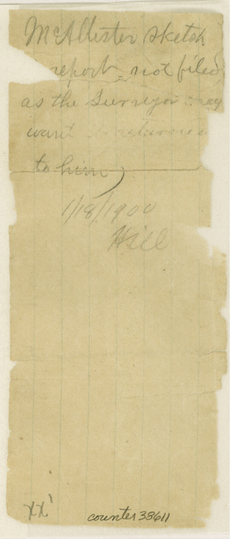
Tyler County Sketch File 1b
[Sketch and explanation of surveys lying north of Village Creek in the south part of the county near the county line]
-
Map/Doc
38611
-
Collection
General Map Collection
-
Object Dates
1/13/1900 (Creation Date)
-
People and Organizations
M.L. McAlister (Surveyor/Engineer)
-
Counties
Tyler Hardin
-
Subjects
Surveying Sketch File
-
Height x Width
7.5 x 3.2 inches
19.1 x 8.1 cm
-
Medium
paper, manuscript
-
Features
Village Creek
Part of: General Map Collection
Haskell County Working Sketch 11

Print $20.00
- Digital $50.00
Haskell County Working Sketch 11
1976
Size 38.0 x 33.4 inches
Map/Doc 66069
Presidio County Rolled Sketch 117

Print $20.00
- Digital $50.00
Presidio County Rolled Sketch 117
Size 29.1 x 28.8 inches
Map/Doc 7392
Comanche County Milam Land District

Print $20.00
- Digital $50.00
Comanche County Milam Land District
1876
Size 22.1 x 23.0 inches
Map/Doc 3433
Armstrong County Working Sketch 7

Print $20.00
- Digital $50.00
Armstrong County Working Sketch 7
Size 18.1 x 16.4 inches
Map/Doc 67238
West and Trans-Pecos Texas with parts of New Mexico and Mexico and a New Map of Big Bend Ranch State Park and Surrounding Area

Print $32.48
West and Trans-Pecos Texas with parts of New Mexico and Mexico and a New Map of Big Bend Ranch State Park and Surrounding Area
1988
Size 28.0 x 31.0 inches
Map/Doc 89070
Polk County Rolled Sketch TS

Print $40.00
- Digital $50.00
Polk County Rolled Sketch TS
1937
Size 37.9 x 58.9 inches
Map/Doc 9755
Reagan County Working Sketch 11

Print $20.00
- Digital $50.00
Reagan County Working Sketch 11
1943
Size 19.4 x 20.9 inches
Map/Doc 71851
[Surveys on the Rio Frio]
![267, [Surveys on the Rio Frio], General Map Collection](https://historictexasmaps.com/wmedia_w700/maps/267.tif.jpg)
Print $2.00
- Digital $50.00
[Surveys on the Rio Frio]
1847
Size 11.8 x 7.3 inches
Map/Doc 267
Current Miscellaneous File 70

Print $10.00
- Digital $50.00
Current Miscellaneous File 70
Size 14.2 x 8.9 inches
Map/Doc 74150
Parker County Working Sketch 20

Print $20.00
- Digital $50.00
Parker County Working Sketch 20
2005
Map/Doc 83581
Texas, Intracoastal Waterway, Ayres Bay to Aransas Bay

Print $40.00
- Digital $50.00
Texas, Intracoastal Waterway, Ayres Bay to Aransas Bay
1934
Size 33.2 x 48.5 inches
Map/Doc 69997
Amistad International Reservoir on Rio Grande 63

Print $20.00
- Digital $50.00
Amistad International Reservoir on Rio Grande 63
1949
Size 28.2 x 39.5 inches
Map/Doc 73348
You may also like
Castro County Sketch File 3

Print $4.00
- Digital $50.00
Castro County Sketch File 3
1902
Size 11.2 x 8.9 inches
Map/Doc 17458
Railroad Track Map, H&TCRRCo., Falls County, Texas

Print $4.00
- Digital $50.00
Railroad Track Map, H&TCRRCo., Falls County, Texas
1918
Size 11.8 x 18.5 inches
Map/Doc 62860
Atascosa County Sketch File 36

Print $20.00
- Digital $50.00
Atascosa County Sketch File 36
1947
Size 16.0 x 22.3 inches
Map/Doc 10867
General Highway Map. Detail of Cities and Towns in Hays County, Texas [San Marcos and vicinity]
![79514, General Highway Map. Detail of Cities and Towns in Hays County, Texas [San Marcos and vicinity], Texas State Library and Archives](https://historictexasmaps.com/wmedia_w700/maps/79514.tif.jpg)
Print $20.00
General Highway Map. Detail of Cities and Towns in Hays County, Texas [San Marcos and vicinity]
1961
Size 17.9 x 24.5 inches
Map/Doc 79514
Aransas County Aerial Photograph Index Sheet 1

Print $20.00
- Digital $50.00
Aransas County Aerial Photograph Index Sheet 1
1957
Size 22.9 x 18.2 inches
Map/Doc 83659
Burnet County Boundary File 9

Print $12.00
- Digital $50.00
Burnet County Boundary File 9
Size 14.1 x 8.6 inches
Map/Doc 50943
Ochiltree County

Print $20.00
- Digital $50.00
Ochiltree County
1958
Size 44.4 x 35.5 inches
Map/Doc 95603
Reeves County Rolled Sketch 21

Print $20.00
- Digital $50.00
Reeves County Rolled Sketch 21
1978
Size 27.6 x 27.6 inches
Map/Doc 7489
Kinney County Working Sketch 54

Print $20.00
- Digital $50.00
Kinney County Working Sketch 54
1981
Size 40.0 x 32.8 inches
Map/Doc 70236
Leon County Working Sketch 8

Print $20.00
- Digital $50.00
Leon County Working Sketch 8
1931
Size 28.9 x 42.8 inches
Map/Doc 70407
Upshur County Rolled Sketch 3

Print $20.00
- Digital $50.00
Upshur County Rolled Sketch 3
1965
Size 35.3 x 30.0 inches
Map/Doc 8062
Montague County Sketch File 2

Print $24.00
- Digital $50.00
Montague County Sketch File 2
1856
Size 12.0 x 8.5 inches
Map/Doc 31711