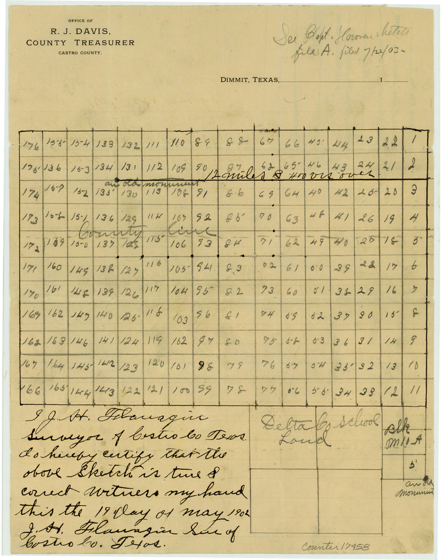
Castro County Sketch File 3
[Sketch of Block M7]
-
Map/Doc
17458
-
Collection
General Map Collection
-
Object Dates
1902/5/19 (Creation Date)
1902/5/23 (File Date)
-
People and Organizations
J.H. Flanagin (Surveyor/Engineer)
-
Counties
Deaf Smith Castro
-
Subjects
Surveying Sketch File
-
Height x Width
11.2 x 8.9 inches
28.4 x 22.6 cm
-
Medium
paper, manuscript
Part of: General Map Collection
[Map of the River Sabine from its mouth on the Gulf of Mexico in the sea to Logan's Ferry in Latitude 31° 58' 24" North]
![94005, [Map of the River Sabine from its mouth on the Gulf of Mexico in the sea to Logan's Ferry in Latitude 31° 58' 24" North], General Map Collection](https://historictexasmaps.com/wmedia_w700/maps/94005.tif.jpg)
Print $20.00
- Digital $50.00
[Map of the River Sabine from its mouth on the Gulf of Mexico in the sea to Logan's Ferry in Latitude 31° 58' 24" North]
Size 31.5 x 31.3 inches
Map/Doc 94005
Oldham County Sketch File 2

Print $6.00
- Digital $50.00
Oldham County Sketch File 2
1882
Size 12.7 x 8.2 inches
Map/Doc 33225
Flight Mission No. DQO-8K, Frame 63, Galveston County

Print $20.00
- Digital $50.00
Flight Mission No. DQO-8K, Frame 63, Galveston County
1952
Size 18.6 x 22.3 inches
Map/Doc 85167
Montague County Working Sketch 40

Print $20.00
- Digital $50.00
Montague County Working Sketch 40
1995
Size 20.6 x 17.5 inches
Map/Doc 71106
Aransas County NRC Article 33.136 Location Key Sheet

Print $20.00
- Digital $50.00
Aransas County NRC Article 33.136 Location Key Sheet
1970
Size 27.0 x 23.0 inches
Map/Doc 87904
[Map of Starr County]
![4049, [Map of Starr County], General Map Collection](https://historictexasmaps.com/wmedia_w700/maps/4049.tif.jpg)
Print $20.00
- Digital $50.00
[Map of Starr County]
Size 18.8 x 16.2 inches
Map/Doc 4049
Cherokee County Sketch File 23

Print $20.00
- Digital $50.00
Cherokee County Sketch File 23
1922
Size 12.8 x 18.5 inches
Map/Doc 11073
Stephens County

Print $20.00
- Digital $50.00
Stephens County
1940
Size 40.3 x 38.9 inches
Map/Doc 77426
Matagorda County Sketch File 45

Print $206.00
- Digital $50.00
Matagorda County Sketch File 45
1967
Size 14.2 x 8.6 inches
Map/Doc 30876
Midland County Boundary File 4a

Print $40.00
- Digital $50.00
Midland County Boundary File 4a
Size 36.2 x 54.5 inches
Map/Doc 57185

Flight Mission No. DIX-8P, Frame 63, Aransas County

Print $20.00
- Digital $50.00
Flight Mission No. DIX-8P, Frame 63, Aransas County
1956
Size 18.7 x 22.5 inches
Map/Doc 83894
You may also like
Knox County Working Sketch 11

Print $20.00
- Digital $50.00
Knox County Working Sketch 11
1950
Size 16.8 x 29.0 inches
Map/Doc 70253
Upton County Working Sketch 50

Print $20.00
- Digital $50.00
Upton County Working Sketch 50
1980
Size 19.5 x 21.4 inches
Map/Doc 69547
Presidio County Rolled Sketch 26

Print $20.00
- Digital $50.00
Presidio County Rolled Sketch 26
1886
Size 33.9 x 26.9 inches
Map/Doc 7333
Madison County Working Sketch 13

Print $20.00
- Digital $50.00
Madison County Working Sketch 13
1995
Size 15.5 x 22.9 inches
Map/Doc 70775
Preliminary Re-Plat of Lots 13-20, 45-52, 77-84, and 97-104 James Subdivision

Print $2.00
- Digital $50.00
Preliminary Re-Plat of Lots 13-20, 45-52, 77-84, and 97-104 James Subdivision
1953
Size 8.7 x 11.3 inches
Map/Doc 93221
Liberty County Rolled Sketch O

Print $40.00
- Digital $50.00
Liberty County Rolled Sketch O
1954
Size 52.3 x 42.8 inches
Map/Doc 10720
Clay County Sketch File 24a

Print $7.00
- Digital $50.00
Clay County Sketch File 24a
1881
Size 11.0 x 8.7 inches
Map/Doc 18439
Concho County Sketch File 24

Print $12.00
- Digital $50.00
Concho County Sketch File 24
1885
Size 11.1 x 8.4 inches
Map/Doc 19149
Sabine River, Dixon Sheet/Cowleach Fork of the Sabine River

Print $20.00
- Digital $50.00
Sabine River, Dixon Sheet/Cowleach Fork of the Sabine River
1935
Size 44.0 x 18.5 inches
Map/Doc 65145
Kimble County Working Sketch 48

Print $20.00
- Digital $50.00
Kimble County Working Sketch 48
1951
Size 23.2 x 22.1 inches
Map/Doc 70116
Hale County Boundary File 2

Print $4.00
- Digital $50.00
Hale County Boundary File 2
Size 10.9 x 8.8 inches
Map/Doc 54044
General Highway Map, Martin County, Texas

Print $20.00
General Highway Map, Martin County, Texas
1940
Size 18.2 x 24.6 inches
Map/Doc 79185