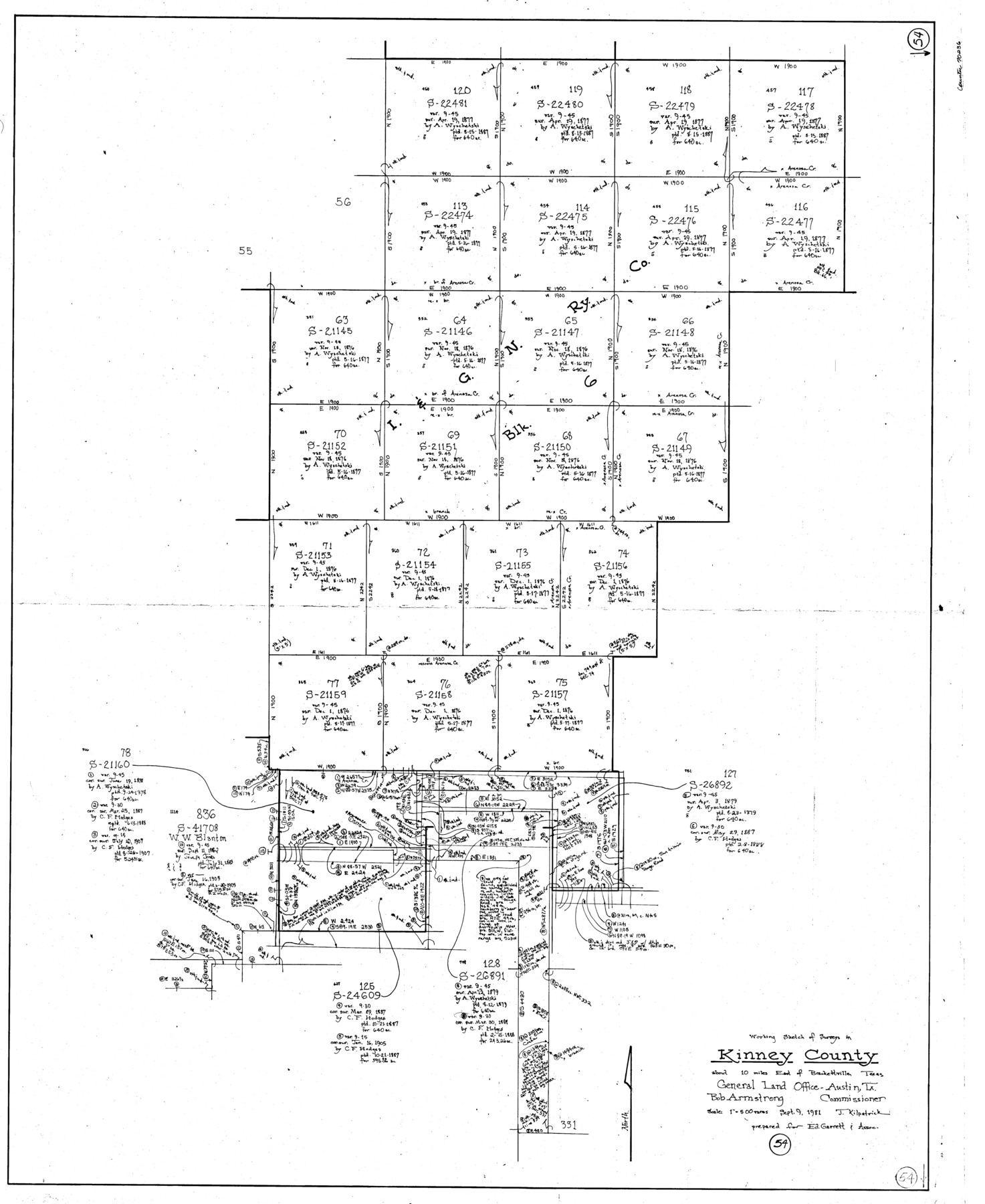
Kinney County Working Sketch 54
-
Map/Doc
70236
-
Collection
General Map Collection
-
Object Dates
9/9/1981 (Creation Date)
-
People and Organizations
Joan Kilpatrick (Draftsman)
-
Counties
Kinney
-
Subjects
Surveying Working Sketch
-
Height x Width
40.0 x 32.8 inches
101.6 x 83.3 cm
-
Scale
1" = 500 varas
Part of: General Map Collection
Bandera County Sketch File 21

Print $4.00
- Digital $50.00
Bandera County Sketch File 21
Size 12.7 x 8.1 inches
Map/Doc 14010
Current Miscellaneous File 16

Print $20.00
- Digital $50.00
Current Miscellaneous File 16
1951
Size 10.7 x 8.2 inches
Map/Doc 73830
Flight Mission No. DAG-26K, Frame 81, Matagorda County

Print $20.00
- Digital $50.00
Flight Mission No. DAG-26K, Frame 81, Matagorda County
1953
Size 18.5 x 22.2 inches
Map/Doc 86586
Potter County Boundary File 5

Print $24.00
- Digital $50.00
Potter County Boundary File 5
Size 15.0 x 9.4 inches
Map/Doc 58013
Birds-eye view of the camp of the army of occupation commanded by Genl. Taylor near Corpus Christi, Texas (from the North)

Print $20.00
- Digital $50.00
Birds-eye view of the camp of the army of occupation commanded by Genl. Taylor near Corpus Christi, Texas (from the North)
1847
Size 15.8 x 20.5 inches
Map/Doc 95951
Wichita County

Print $20.00
- Digital $50.00
Wichita County
1971
Size 35.8 x 37.7 inches
Map/Doc 77457
Hays County Working Sketch 4

Print $20.00
- Digital $50.00
Hays County Working Sketch 4
1928
Size 25.4 x 21.7 inches
Map/Doc 66078
Lampasas County Boundary File 16

Print $14.00
- Digital $50.00
Lampasas County Boundary File 16
Size 8.9 x 8.2 inches
Map/Doc 56216
Jasper County Sketch File 16

Print $20.00
- Digital $50.00
Jasper County Sketch File 16
Size 16.8 x 16.2 inches
Map/Doc 11849
Marion County Working Sketch 28

Print $20.00
- Digital $50.00
Marion County Working Sketch 28
1975
Size 24.0 x 33.5 inches
Map/Doc 70804
Harbor Pass and Bar at Brazos Santiago, Texas

Print $20.00
- Digital $50.00
Harbor Pass and Bar at Brazos Santiago, Texas
1879
Size 18.2 x 27.6 inches
Map/Doc 72999
Panola County Working Sketch 11

Print $20.00
- Digital $50.00
Panola County Working Sketch 11
1944
Map/Doc 71420
You may also like
Eastland County Rolled Sketch 24

Print $20.00
- Digital $50.00
Eastland County Rolled Sketch 24
1983
Size 33.5 x 38.0 inches
Map/Doc 8830
Garza County Sketch File 4a

Print $4.00
- Digital $50.00
Garza County Sketch File 4a
1883
Size 14.2 x 8.8 inches
Map/Doc 24048
Lynn County Boundary File 4

Print $4.00
- Digital $50.00
Lynn County Boundary File 4
Size 11.3 x 8.7 inches
Map/Doc 56626
Uvalde County Working Sketch 3

Print $20.00
- Digital $50.00
Uvalde County Working Sketch 3
1915
Size 37.9 x 34.1 inches
Map/Doc 72073
The Republic County of Nacogdoches. Proposed, Late Fall 1837

Print $20.00
The Republic County of Nacogdoches. Proposed, Late Fall 1837
2020
Size 17.5 x 21.7 inches
Map/Doc 96242
New Map of the Mining Regions of Idaho and Montana showing the geographical positions of the Blackfoot, Owyhee & South Boise Mines and the various routes thereto

Print $20.00
- Digital $50.00
New Map of the Mining Regions of Idaho and Montana showing the geographical positions of the Blackfoot, Owyhee & South Boise Mines and the various routes thereto
Size 21.9 x 29.4 inches
Map/Doc 93991
Travis County Working Sketch 68

Print $20.00
- Digital $50.00
Travis County Working Sketch 68
2019
Size 23.8 x 36.0 inches
Map/Doc 95687
Harris County NRC Article 33.136 Location Key Sheet

Print $20.00
- Digital $50.00
Harris County NRC Article 33.136 Location Key Sheet
1995
Size 27.0 x 21.8 inches
Map/Doc 77027
Cass County Working Sketch 26

Print $20.00
- Digital $50.00
Cass County Working Sketch 26
1974
Size 32.1 x 28.9 inches
Map/Doc 67929
Intracoastal Waterway, Houma, LA to Corpus Christi, TX

Print $5.00
- Digital $50.00
Intracoastal Waterway, Houma, LA to Corpus Christi, TX
Size 22.3 x 28.0 inches
Map/Doc 61914
Flight Mission No. BRA-16M, Frame 71, Jefferson County

Print $20.00
- Digital $50.00
Flight Mission No. BRA-16M, Frame 71, Jefferson County
1953
Size 18.7 x 22.3 inches
Map/Doc 85688
America's Fun-Tier: Texas 1966 Official State Highway Map

Digital $50.00
America's Fun-Tier: Texas 1966 Official State Highway Map
Size 28.2 x 36.5 inches
Map/Doc 94324