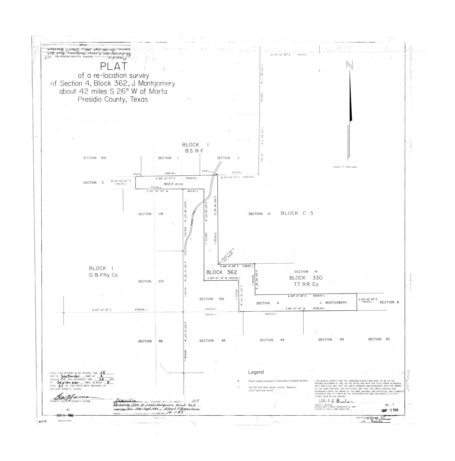
Presidio County Rolled Sketch 117
Plat of a re-location survey of section 4, Block 362, J. Montgomery
-
Map/Doc
7392
-
Collection
General Map Collection
-
Object Dates
1982 (Survey Date)
1982/10/1 (File Date)
-
People and Organizations
Elbert F. Bassham (Surveyor/Engineer)
-
Counties
Presidio
-
Subjects
Surveying Rolled Sketch
-
Height x Width
29.1 x 28.8 inches
73.9 x 73.2 cm
-
Medium
mylar, print
-
Scale
1" = 500 varas
Part of: General Map Collection
Oldham County Working Sketch Graphic Index

Print $40.00
- Digital $50.00
Oldham County Working Sketch Graphic Index
1925
Size 42.2 x 51.7 inches
Map/Doc 76657
Ward County Boundary File 1

Print $12.00
- Digital $50.00
Ward County Boundary File 1
Size 14.4 x 9.0 inches
Map/Doc 59667
Sutton County Sketch File 18

Print $94.00
- Digital $50.00
Sutton County Sketch File 18
1893
Size 12.9 x 8.3 inches
Map/Doc 37410
Bexar County Sketch File 1a

Print $24.00
- Digital $50.00
Bexar County Sketch File 1a
1847
Size 12.7 x 8.2 inches
Map/Doc 14468

Township 6 North Range 14 West, North Western District, Louisiana

Print $20.00
- Digital $50.00
Township 6 North Range 14 West, North Western District, Louisiana
1841
Size 19.5 x 24.7 inches
Map/Doc 65863
Parker County Sketch File 40

Print $4.00
- Digital $50.00
Parker County Sketch File 40
Size 8.1 x 12.7 inches
Map/Doc 33585
[Surveys in the Bexar District along the Frio River]
![315, [Surveys in the Bexar District along the Frio River], General Map Collection](https://historictexasmaps.com/wmedia_w700/maps/315.tif.jpg)
Print $2.00
- Digital $50.00
[Surveys in the Bexar District along the Frio River]
1847
Size 15.8 x 9.2 inches
Map/Doc 315
Hudspeth County Rolled Sketch 38

Print $20.00
- Digital $50.00
Hudspeth County Rolled Sketch 38
1939
Size 18.0 x 37.5 inches
Map/Doc 6251
Flight Mission No. BRA-16M, Frame 150, Jefferson County

Print $20.00
- Digital $50.00
Flight Mission No. BRA-16M, Frame 150, Jefferson County
1953
Size 18.5 x 22.3 inches
Map/Doc 85756
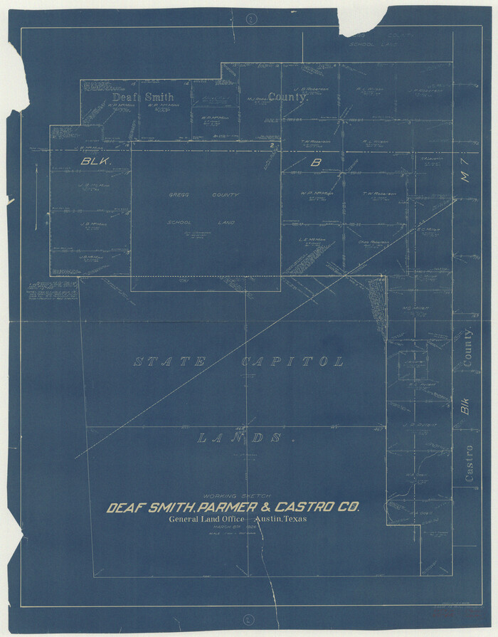
Deaf Smith County Working Sketch 2
Print $20.00
- Digital $50.00
Deaf Smith County Working Sketch 2
1926
Size 42.3 x 33.1 inches
Map/Doc 68642
Survey of The Rio Grande Roma to the Gulf of Mexico

Survey of The Rio Grande Roma to the Gulf of Mexico
Map/Doc 81739
You may also like
Travis County Rolled Sketch 15

Print $20.00
- Digital $50.00
Travis County Rolled Sketch 15
1939
Size 25.4 x 37.6 inches
Map/Doc 10011
Culberson County Working Sketch 74

Print $40.00
- Digital $50.00
Culberson County Working Sketch 74
1975
Size 51.4 x 35.5 inches
Map/Doc 68528
Guadalupe County Working Sketch 5

Print $3.00
- Digital $50.00
Guadalupe County Working Sketch 5
1940
Size 15.2 x 10.9 inches
Map/Doc 63314
Supreme Court of the United States, October Term, 1924, No. 13, Original - The State of Oklahoma, Complainant vs. The State of Texas, Defendant, The United States, Intervener

Print $20.00
- Digital $50.00
Supreme Court of the United States, October Term, 1924, No. 13, Original - The State of Oklahoma, Complainant vs. The State of Texas, Defendant, The United States, Intervener
1924
Size 22.1 x 38.7 inches
Map/Doc 75130
Railroad Commissioners' Map of Texas

Print $20.00
Railroad Commissioners' Map of Texas
1897
Size 23.2 x 27.6 inches
Map/Doc 76280
Flight Mission No. DAG-23K, Frame 165, Matagorda County

Print $20.00
- Digital $50.00
Flight Mission No. DAG-23K, Frame 165, Matagorda County
1953
Size 17.0 x 19.0 inches
Map/Doc 86503
Collingsworth County

Print $20.00
- Digital $50.00
Collingsworth County
1971
Size 40.7 x 34.2 inches
Map/Doc 77243
Jeff Davis County Working Sketch 7

Print $20.00
- Digital $50.00
Jeff Davis County Working Sketch 7
1938
Size 30.4 x 39.9 inches
Map/Doc 66502
English Field Notes of the Spanish Archives - Books GMP, FH, SCH, and JAV

English Field Notes of the Spanish Archives - Books GMP, FH, SCH, and JAV
1835
Map/Doc 96545
Hockley County Sketch Mineral Application Number 38322- 38379

Print $20.00
- Digital $50.00
Hockley County Sketch Mineral Application Number 38322- 38379
1946
Size 34.1 x 27.8 inches
Map/Doc 92242
Crane County Working Sketch Graphic Index, Sheet B

Print $20.00
- Digital $50.00
Crane County Working Sketch Graphic Index, Sheet B
1945
Size 44.8 x 33.6 inches
Map/Doc 76508
Webb County Working Sketch 41

Print $20.00
- Digital $50.00
Webb County Working Sketch 41
1941
Size 15.7 x 18.8 inches
Map/Doc 72406