Tarrant County Sketch File 32
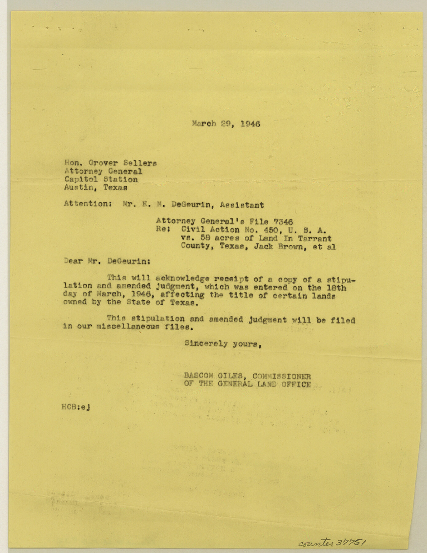
[Correspondence and copy of Attorney General's File 7436 regarding Civil Action 450, USA vs. 58 acres of land, more or less, State of Texas and Jack Brown, et al]
-
Map/Doc
37751
-
Collection
General Map Collection
-
Object Dates
3/23/1946 (Creation Date)
3/28/1946 (File Date)
-
People and Organizations
Bascom Giles (Commissioner)
-
Counties
Tarrant
-
Subjects
Surveying Sketch File
-
Height x Width
11.3 x 8.8 inches
28.7 x 22.4 cm
-
Medium
paper, print
-
Features
Fort Worth
Riverlake Addition
Trinity River
Part of: General Map Collection
Culberson County Working Sketch 58

Print $20.00
- Digital $50.00
Culberson County Working Sketch 58
1974
Size 45.2 x 35.1 inches
Map/Doc 68512
Henderson County

Print $40.00
- Digital $50.00
Henderson County
1988
Size 35.3 x 69.7 inches
Map/Doc 95528
Kinney County Sketch File 16a

Print $40.00
- Digital $50.00
Kinney County Sketch File 16a
Size 12.8 x 16.0 inches
Map/Doc 29133
Flight Mission No. DQN-1K, Frame 31, Calhoun County

Print $20.00
- Digital $50.00
Flight Mission No. DQN-1K, Frame 31, Calhoun County
1953
Size 15.4 x 15.5 inches
Map/Doc 84136
Reeves County Working Sketch 45

Print $20.00
- Digital $50.00
Reeves County Working Sketch 45
1974
Size 46.9 x 32.3 inches
Map/Doc 63488
Bowie County Sketch File 8

Print $42.00
- Digital $50.00
Bowie County Sketch File 8
1927
Size 8.9 x 3.8 inches
Map/Doc 14872
Kleberg County Rolled Sketch 10-21

Print $20.00
- Digital $50.00
Kleberg County Rolled Sketch 10-21
1952
Size 37.5 x 32.9 inches
Map/Doc 9403
Dawson County Sketch File 15

Print $40.00
- Digital $50.00
Dawson County Sketch File 15
Size 17.8 x 7.9 inches
Map/Doc 20549

Stephens County Working Sketch 7

Print $20.00
- Digital $50.00
Stephens County Working Sketch 7
1919
Size 26.9 x 16.6 inches
Map/Doc 63950
Dickens County Rolled Sketch 12

Print $20.00
- Digital $50.00
Dickens County Rolled Sketch 12
1959
Size 33.5 x 39.7 inches
Map/Doc 8790
Medina County Working Sketch 32

Print $20.00
- Digital $50.00
Medina County Working Sketch 32
1994
Size 30.4 x 42.4 inches
Map/Doc 70947
You may also like
Hall County Sketch File 28

Print $20.00
- Digital $50.00
Hall County Sketch File 28
1913
Size 18.0 x 21.5 inches
Map/Doc 11611
Sectional map of Texas traversed by the Missouri, Kansas & Texas Railway, showing the crops adapted to each section, with the elevation and annual rainfall

Print $20.00
- Digital $50.00
Sectional map of Texas traversed by the Missouri, Kansas & Texas Railway, showing the crops adapted to each section, with the elevation and annual rainfall
1904
Size 21.9 x 23.0 inches
Map/Doc 95815
Upton County Working Sketch 6

Print $20.00
- Digital $50.00
Upton County Working Sketch 6
1909
Size 17.1 x 27.0 inches
Map/Doc 69502
Bell County Sketch File 33

Print $6.00
- Digital $50.00
Bell County Sketch File 33
Size 14.4 x 8.7 inches
Map/Doc 14452
Calhoun County Working Sketch 10

Print $20.00
- Digital $50.00
Calhoun County Working Sketch 10
1951
Size 36.8 x 37.2 inches
Map/Doc 67826
Webb County Sketch File 45

Print $20.00
- Digital $50.00
Webb County Sketch File 45
1883
Size 17.5 x 22.5 inches
Map/Doc 12642
Crane County Sketch File 3

Print $20.00
- Digital $50.00
Crane County Sketch File 3
Size 23.6 x 26.0 inches
Map/Doc 11204

Showing how the New County of Durant is bounded, from Official Maps from the General Land Office of Galveston, Harris, Fort Bend, and Brazoria Counties

Print $20.00
- Digital $50.00
Showing how the New County of Durant is bounded, from Official Maps from the General Land Office of Galveston, Harris, Fort Bend, and Brazoria Counties
1880
Size 18.6 x 19.0 inches
Map/Doc 4473
Map of Block 1, H. & G. N. Railroad Company

Print $20.00
- Digital $50.00
Map of Block 1, H. & G. N. Railroad Company
1909
Size 24.0 x 30.1 inches
Map/Doc 91017
Grayson County Boundary File 35

Print $42.00
- Digital $50.00
Grayson County Boundary File 35
Size 9.3 x 7.9 inches
Map/Doc 53961
Martin County Boundary File 2b

Print $40.00
- Digital $50.00
Martin County Boundary File 2b
Size 46.4 x 20.2 inches
Map/Doc 56779