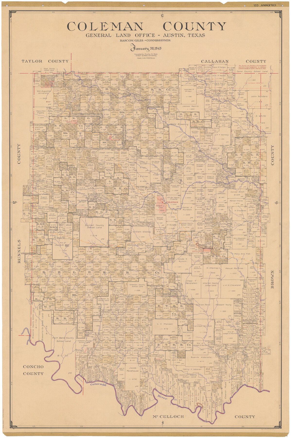
Coleman County
-
Map/Doc
73109
-
Collection
General Map Collection
-
Object Dates
1945/1/30 (Creation Date)
-
People and Organizations
Texas General Land Office (Publisher)
Curtis R. Hale (Compiler)
Eltea Armstrong (Draftsman)
Bascom Giles (GLO Commissioner)
-
Counties
Coleman
-
Subjects
County
-
Height x Width
54.7 x 37.1 inches
138.9 x 94.2 cm
-
Comments
Hand lettered.
Note on reverse side: "Compilation completed January 30, 1945. Inking completed June 16, 1945. Tracing completed September 10, 1945. Placed in Official use September 11, 1945. Replaced [on sticks] by copy June 17, 1946." -
Features
Campbells Creek
Pilot Knob
Cedar Creek
West Fork of Mukewater Creek
Santa Anna
Home Creek
Valera
Bead Mountain
Elm Creek
Middle Fork of Mukewater Creek
Little David's Creek
Talpa
East Fork of Mukewater Creek
Urania Creek
Thalia Creek
Camp Creek
Mukewater Creek
Bradys Bend [of Colorado River]
Colorado River
Chaffin Crossing
Parks Mountain
Mitchel Crossing
Turtle Bayou
Little Pecan Bayou
Greenbrier Creek
Goldsboro
Jim Ned Peak
Longhollow Creek
Pecan Bayou
Rough Creek
South Jim Ned Creek
Novice
Bluff Creek
Burnt Creek
Jim Ned Creek
Cow Creek
Silver Valley
Robinson Peak
Indian Creek
Hords Creek
Coleman
Watts Creek
Cunningham Creek
GC&SF
Part of: General Map Collection
Falls County Sketch File 2

Print $4.00
- Digital $50.00
Falls County Sketch File 2
1854
Size 13.1 x 8.3 inches
Map/Doc 22332
Flight Mission No. DAG-26K, Frame 61, Matagorda County

Print $20.00
- Digital $50.00
Flight Mission No. DAG-26K, Frame 61, Matagorda County
1953
Size 18.7 x 22.6 inches
Map/Doc 86581
Map of the Paluxy Artesian Reservoirs of the Black and Grand Prairies of Texas including the Eastern and Western Cross Timbers

Print $20.00
- Digital $50.00
Map of the Paluxy Artesian Reservoirs of the Black and Grand Prairies of Texas including the Eastern and Western Cross Timbers
1900
Size 24.8 x 24.4 inches
Map/Doc 75919
Hardeman County

Print $20.00
- Digital $50.00
Hardeman County
1891
Size 24.9 x 19.9 inches
Map/Doc 4560
Crockett County Sketch File 94

Print $6.00
- Digital $50.00
Crockett County Sketch File 94
1940
Size 9.2 x 12.3 inches
Map/Doc 19950
Galveston County NRC Article 33.136 Sketch 41

Print $28.00
- Digital $50.00
Galveston County NRC Article 33.136 Sketch 41
2006
Size 29.8 x 42.4 inches
Map/Doc 83074
Flight Mission No. DIX-10P, Frame 177, Aransas County

Print $20.00
- Digital $50.00
Flight Mission No. DIX-10P, Frame 177, Aransas County
1956
Size 18.6 x 22.3 inches
Map/Doc 83967
Robertson County Working Sketch 2

Print $20.00
- Digital $50.00
Robertson County Working Sketch 2
1939
Size 14.5 x 16.3 inches
Map/Doc 63575
Flight Mission No. DCL-6C, Frame 48, Kenedy County

Print $20.00
- Digital $50.00
Flight Mission No. DCL-6C, Frame 48, Kenedy County
1943
Size 18.7 x 22.3 inches
Map/Doc 85890
Pecos County Sketch File 80

Print $6.00
- Digital $50.00
Pecos County Sketch File 80
1942
Size 8.9 x 11.9 inches
Map/Doc 33918
Montgomery County Working Sketch 54

Print $20.00
- Digital $50.00
Montgomery County Working Sketch 54
1961
Size 30.6 x 28.3 inches
Map/Doc 71161
Kimble County Sketch File L1

Print $22.00
- Digital $50.00
Kimble County Sketch File L1
Size 7.1 x 13.1 inches
Map/Doc 28967
You may also like

Moore County Working Sketch 1

Print $20.00
- Digital $50.00
Moore County Working Sketch 1
1909
Size 32.0 x 32.4 inches
Map/Doc 71183

Jefferson County Sketch File 6

Print $4.00
- Digital $50.00
Jefferson County Sketch File 6
1860
Size 12.3 x 7.8 inches
Map/Doc 28110
Hansford County

Print $20.00
- Digital $50.00
Hansford County
1902
Size 38.8 x 34.9 inches
Map/Doc 4696
Brazoria County NRC Article 33.136 Sketch 17

Print $88.00
- Digital $50.00
Brazoria County NRC Article 33.136 Sketch 17
2015
Size 22.0 x 34.0 inches
Map/Doc 95020
Flight Mission No. DQN-1K, Frame 120, Calhoun County

Print $20.00
- Digital $50.00
Flight Mission No. DQN-1K, Frame 120, Calhoun County
1953
Size 18.5 x 22.2 inches
Map/Doc 84186
Webb County Sketch File 3a

Print $40.00
- Digital $50.00
Webb County Sketch File 3a
1855
Size 32.1 x 20.8 inches
Map/Doc 12613
[Worksheets related to the Wilson Strickland survey and vicinity]
![91302, [Worksheets related to the Wilson Strickland survey and vicinity], Twichell Survey Records](https://historictexasmaps.com/wmedia_w700/maps/91302-1.tif.jpg)
Print $20.00
- Digital $50.00
[Worksheets related to the Wilson Strickland survey and vicinity]
Size 22.0 x 25.6 inches
Map/Doc 91302
Eastland County Sketch File 20

Print $62.00
- Digital $50.00
Eastland County Sketch File 20
1987
Size 9.1 x 11.3 inches
Map/Doc 21609
Hansford County

Print $20.00
- Digital $50.00
Hansford County
1889
Size 22.9 x 18.5 inches
Map/Doc 3624
Freestone County Rolled Sketch 7

Print $20.00
- Digital $50.00
Freestone County Rolled Sketch 7
1918
Size 41.4 x 36.9 inches
Map/Doc 8895