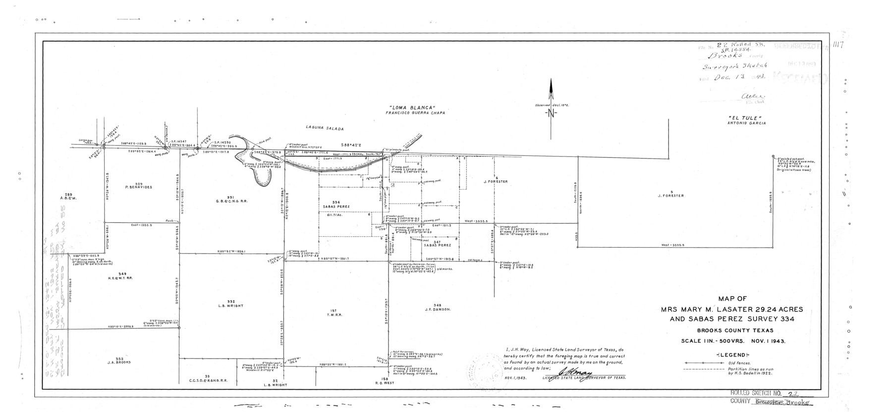
Brooks County Rolled Sketch 22
Map of Mrs. Mary M. Lasater 29.24 acres and Sabas Perez survey 334
-
Map/Doc
5343
-
Collection
General Map Collection
-
Object Dates
1943/11/1 (Creation Date)
1943/12/13 (File Date)
-
People and Organizations
J.H. May (Surveyor/Engineer)
-
Counties
Brooks
-
Subjects
Surveying Rolled Sketch
-
Height x Width
15.1 x 32.2 inches
38.4 x 81.8 cm
-
Scale
1" = 500 varas
Part of: General Map Collection
Medina County Working Sketch 31

Print $20.00
- Digital $50.00
Medina County Working Sketch 31
1993
Size 27.2 x 20.8 inches
Map/Doc 70946
Motley County Sketch File 7a (N)

Print $40.00
- Digital $50.00
Motley County Sketch File 7a (N)
1895
Size 13.5 x 14.4 inches
Map/Doc 32014
Collin County Sketch File 9

Print $4.00
- Digital $50.00
Collin County Sketch File 9
1878
Size 8.3 x 10.1 inches
Map/Doc 18870
[Right of Way & Track Map, The Texas & Pacific Ry. Co. Main Line]
![64675, [Right of Way & Track Map, The Texas & Pacific Ry. Co. Main Line], General Map Collection](https://historictexasmaps.com/wmedia_w700/maps/64675.tif.jpg)
Print $20.00
- Digital $50.00
[Right of Way & Track Map, The Texas & Pacific Ry. Co. Main Line]
Size 11.0 x 18.4 inches
Map/Doc 64675
Central Part of Jeff Davis Co.

Print $40.00
- Digital $50.00
Central Part of Jeff Davis Co.
1982
Size 55.4 x 43.9 inches
Map/Doc 73193
City of Austin and Vicinity

Print $20.00
- Digital $50.00
City of Austin and Vicinity
1839
Size 20.4 x 19.6 inches
Map/Doc 3149
Reagan County Working Sketch 33

Print $40.00
- Digital $50.00
Reagan County Working Sketch 33
1965
Size 66.2 x 42.0 inches
Map/Doc 71875
Travis County Rolled Sketch 37

Print $20.00
- Digital $50.00
Travis County Rolled Sketch 37
1942
Size 33.6 x 32.7 inches
Map/Doc 10737
Liberty County Sketch File 14

Print $4.00
- Digital $50.00
Liberty County Sketch File 14
1858
Size 12.9 x 8.1 inches
Map/Doc 29915
Zapata County Working Sketch 15

Print $20.00
- Digital $50.00
Zapata County Working Sketch 15
1969
Size 38.2 x 38.7 inches
Map/Doc 62066
Crockett County Sketch File 71

Print $8.00
- Digital $50.00
Crockett County Sketch File 71
1934
Size 11.2 x 8.8 inches
Map/Doc 19858
[Index of Texas Prison Farms]
![62977, [Index of Texas Prison Farms], General Map Collection](https://historictexasmaps.com/wmedia_w700/maps/62977.tif.jpg)
Print $20.00
- Digital $50.00
[Index of Texas Prison Farms]
Size 31.1 x 23.1 inches
Map/Doc 62977
You may also like
Rullmann's map of the city of San Antonio

Print $20.00
Rullmann's map of the city of San Antonio
1890
Size 34.6 x 31.0 inches
Map/Doc 93555
Galveston County NRC Article 33.136 Sketch 24

Print $22.00
- Digital $50.00
Galveston County NRC Article 33.136 Sketch 24
2003
Size 24.8 x 36.3 inches
Map/Doc 87919
Flight Mission No. CRC-4R, Frame 109, Chambers County

Print $20.00
- Digital $50.00
Flight Mission No. CRC-4R, Frame 109, Chambers County
1956
Size 18.5 x 22.5 inches
Map/Doc 84906
Briscoe County Sketch File 13

Print $168.00
- Digital $50.00
Briscoe County Sketch File 13
1982
Size 11.2 x 8.7 inches
Map/Doc 16428
Flight Mission No. CRK-7P, Frame 133, Refugio County

Print $20.00
- Digital $50.00
Flight Mission No. CRK-7P, Frame 133, Refugio County
1956
Size 18.3 x 22.1 inches
Map/Doc 86956
Hardeman County Sketch File 9

Print $20.00
- Digital $50.00
Hardeman County Sketch File 9
1884
Size 27.7 x 30.1 inches
Map/Doc 11624
Sections 13 & 12, Block S

Print $20.00
- Digital $50.00
Sections 13 & 12, Block S
Size 23.0 x 18.2 inches
Map/Doc 92835
Flight Mission No. BQY-15M, Frame 12, Harris County

Print $20.00
- Digital $50.00
Flight Mission No. BQY-15M, Frame 12, Harris County
1953
Size 18.7 x 22.4 inches
Map/Doc 85310
C No. 2 - Preliminary Sketch of Chincoteague Inlet and Shoals in the Vicinity - Sea Coast of Virginia

Print $20.00
- Digital $50.00
C No. 2 - Preliminary Sketch of Chincoteague Inlet and Shoals in the Vicinity - Sea Coast of Virginia
1852
Size 16.5 x 19.4 inches
Map/Doc 97206
Runnels County Working Sketch 8

Print $20.00
- Digital $50.00
Runnels County Working Sketch 8
1948
Size 38.4 x 37.1 inches
Map/Doc 63604
Wichita County

Print $20.00
- Digital $50.00
Wichita County
1881
Size 18.5 x 19.8 inches
Map/Doc 4143
Matagorda Light to Aransas Pass

Print $20.00
- Digital $50.00
Matagorda Light to Aransas Pass
1946
Size 35.8 x 44.5 inches
Map/Doc 73394