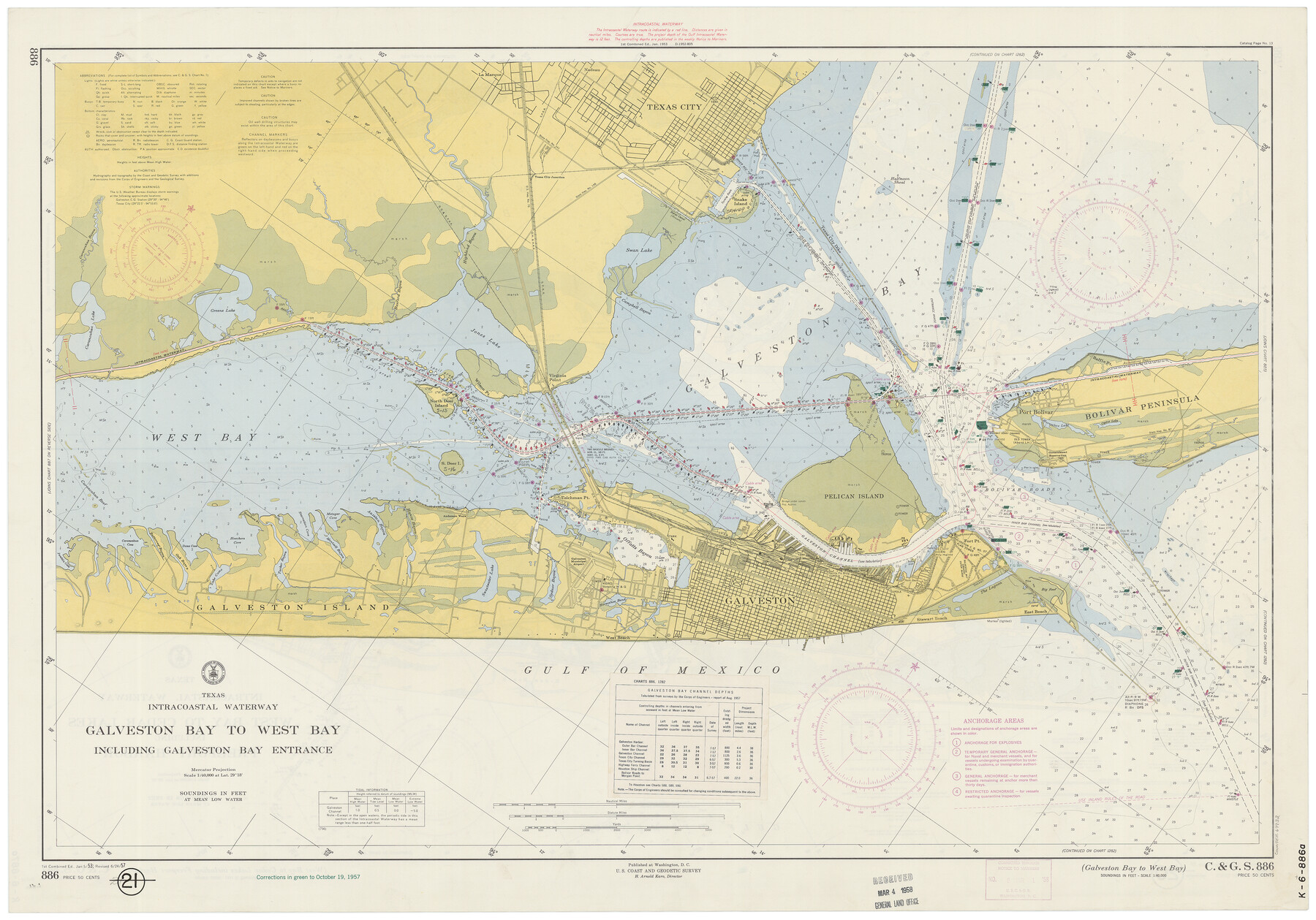
Intracoastal Waterway - Galveston Bay to West Bay including Galveston Bay Entrance
Intracoastal Waterway - West Bay to Cedar Lakes including Freeport Harbor
K-6-886a; K-6-887a
-
Map/Doc
69932
-
Collection
General Map Collection
-
Object Dates
6/24/1957 (Creation Date)
-
Counties
Galveston
-
Subjects
Nautical Charts
-
Height x Width
27.2 x 38.6 inches
69.1 x 98.0 cm
-
Comments
dual-sided map
Part of: General Map Collection
United States - Gulf Coast Texas - Northern part of Laguna Madre

Print $20.00
- Digital $50.00
United States - Gulf Coast Texas - Northern part of Laguna Madre
1941
Size 18.3 x 24.0 inches
Map/Doc 72937
Uvalde County Working Sketch 18

Print $20.00
- Digital $50.00
Uvalde County Working Sketch 18
1948
Size 33.0 x 26.5 inches
Map/Doc 72088
Nueces County NRC Article 33.136 Sketch 10

Print $36.00
- Digital $50.00
Nueces County NRC Article 33.136 Sketch 10
2004
Size 23.9 x 35.9 inches
Map/Doc 83526
Swisher County Rolled Sketch B

Print $20.00
- Digital $50.00
Swisher County Rolled Sketch B
Size 19.1 x 19.7 inches
Map/Doc 7908
Map of Hill County

Print $20.00
- Digital $50.00
Map of Hill County
1857
Size 21.5 x 25.6 inches
Map/Doc 3672
Coryell County Sketch File 17 1/2

Print $20.00
- Digital $50.00
Coryell County Sketch File 17 1/2
Size 16.0 x 23.6 inches
Map/Doc 11182
Frio County Rolled Sketch 6

Print $20.00
- Digital $50.00
Frio County Rolled Sketch 6
1938
Size 42.7 x 32.6 inches
Map/Doc 76019
Carte d'une partie de l'Amérique Séptentrionale, qui contient partie de la Nle. Espagne, et de la Louisiane

Print $20.00
- Digital $50.00
Carte d'une partie de l'Amérique Séptentrionale, qui contient partie de la Nle. Espagne, et de la Louisiane
1782
Size 14.1 x 18.5 inches
Map/Doc 94096
Bee County Sketch File 23

Print $8.00
- Digital $50.00
Bee County Sketch File 23
1878
Size 10.0 x 8.1 inches
Map/Doc 14318
Travis County Appraisal District Plat Map 2_1002

Print $20.00
- Digital $50.00
Travis County Appraisal District Plat Map 2_1002
Size 21.4 x 26.5 inches
Map/Doc 94230
Moore County Working Sketch 14

Print $20.00
- Digital $50.00
Moore County Working Sketch 14
1972
Size 32.7 x 19.8 inches
Map/Doc 71196
Deaf Smith County Sketch File 1a

Print $21.00
- Digital $50.00
Deaf Smith County Sketch File 1a
Size 11.5 x 9.2 inches
Map/Doc 20616
You may also like
Tom Green County

Print $40.00
- Digital $50.00
Tom Green County
1942
Size 55.3 x 46.8 inches
Map/Doc 73304
Presidio County Rolled Sketch 35

Print $20.00
- Digital $50.00
Presidio County Rolled Sketch 35
Size 44.7 x 32.1 inches
Map/Doc 9774
McMullen County Sketch File 16a

Print $40.00
- Digital $50.00
McMullen County Sketch File 16a
Size 12.5 x 12.5 inches
Map/Doc 31367
Flight Mission No. DQN-1K, Frame 65, Calhoun County

Print $20.00
- Digital $50.00
Flight Mission No. DQN-1K, Frame 65, Calhoun County
1953
Size 18.5 x 22.2 inches
Map/Doc 84152
Pecos County Working Sketch 9

Print $20.00
- Digital $50.00
Pecos County Working Sketch 9
1907
Size 32.4 x 26.7 inches
Map/Doc 71479
No. 3 Chart of Channel connecting Corpus Christi Bay with Aransas Bay, Texas

Print $20.00
- Digital $50.00
No. 3 Chart of Channel connecting Corpus Christi Bay with Aransas Bay, Texas
1878
Size 18.4 x 28.0 inches
Map/Doc 72771
Culberson County Working Sketch 49

Print $40.00
- Digital $50.00
Culberson County Working Sketch 49
1972
Size 49.2 x 37.6 inches
Map/Doc 68503
Harrison County Sketch File 8

Print $20.00
- Digital $50.00
Harrison County Sketch File 8
1861
Size 17.3 x 15.9 inches
Map/Doc 11685
Galveston Bay Entrance, Series No. 518

Print $40.00
- Digital $50.00
Galveston Bay Entrance, Series No. 518
1971
Size 18.0 x 49.9 inches
Map/Doc 69862
Trinity River, Wildcat Ferry Sheet

Print $20.00
- Digital $50.00
Trinity River, Wildcat Ferry Sheet
1928
Size 41.5 x 40.9 inches
Map/Doc 65182
Blanco County Working Sketch 24

Print $20.00
- Digital $50.00
Blanco County Working Sketch 24
1963
Size 30.2 x 31.2 inches
Map/Doc 67384
Reagan County Working Sketch 10

Print $20.00
- Digital $50.00
Reagan County Working Sketch 10
1942
Size 21.5 x 27.2 inches
Map/Doc 71850