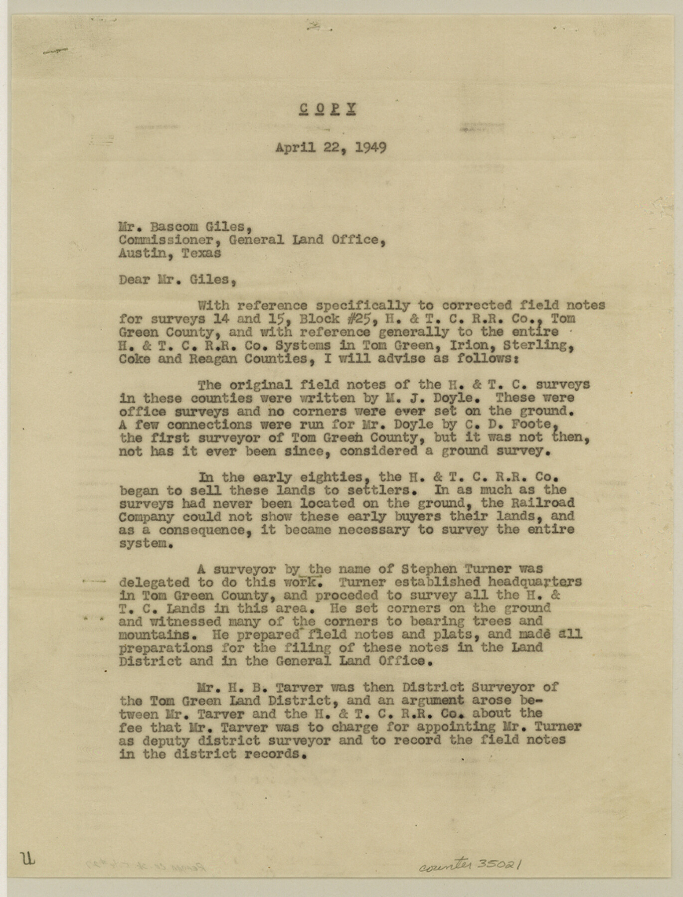
Reagan County Sketch File 27
[Report regarding Turner corners]
-
Map/Doc
35021
-
Collection
General Map Collection
-
Object Dates
1949/4/22 (Creation Date)
1949/4/28 (File Date)
1949/4/22 (Correspondence Date)
-
People and Organizations
H.L. George (Surveyor/Engineer)
M.J. Doyle (Surveyor/Engineer)
C.D. Foote (Surveyor/Engineer)
Stephen Turner (Surveyor/Engineer)
H.B. Tarver (Surveyor/Engineer)
J.J. Goodfellow (Surveyor/Engineer)
H.M. Garden (Surveyor/Engineer)
-
Counties
Reagan Tom Green
-
Subjects
Surveying Sketch File
-
Height x Width
11.4 x 8.7 inches
29.0 x 22.1 cm
-
Medium
paper, print
Part of: General Map Collection
Freestone County Rolled Sketch 14

Print $20.00
- Digital $50.00
Freestone County Rolled Sketch 14
Size 29.4 x 19.8 inches
Map/Doc 78601
Photostat of section of hydrographic surveys H-5399, H-4822, H-470

Print $2.00
- Digital $50.00
Photostat of section of hydrographic surveys H-5399, H-4822, H-470
1933
Size 10.8 x 8.1 inches
Map/Doc 61157
Flight Mission No. BRA-16M, Frame 119, Jefferson County

Print $20.00
- Digital $50.00
Flight Mission No. BRA-16M, Frame 119, Jefferson County
1953
Size 18.6 x 22.5 inches
Map/Doc 85729
Morris County Rolled Sketch 2A

Print $20.00
- Digital $50.00
Morris County Rolled Sketch 2A
Size 24.0 x 18.7 inches
Map/Doc 10234
Supreme Court of the United States, October Term, 1923, No. 15, Original - The State of Oklahoma, Complainant vs. The State of Texas, Defendant, The United States, Intervener; Report of the Boundary Commissioners

Print $40.00
- Digital $50.00
Supreme Court of the United States, October Term, 1923, No. 15, Original - The State of Oklahoma, Complainant vs. The State of Texas, Defendant, The United States, Intervener; Report of the Boundary Commissioners
1923
Size 57.5 x 33.4 inches
Map/Doc 77591
Plan of the City of Galveston, Texas

Print $20.00
- Digital $50.00
Plan of the City of Galveston, Texas
1845
Size 18.4 x 27.8 inches
Map/Doc 62970
Harris County Sketch File 27

Print $12.00
- Digital $50.00
Harris County Sketch File 27
1886
Size 10.3 x 8.2 inches
Map/Doc 25397


Bandera County Boundary File 2

Print $4.00
- Digital $50.00
Bandera County Boundary File 2
Size 9.1 x 7.5 inches
Map/Doc 50264
Map of Corpus Christi Bay in Nueces County Showing Subdivision Thereof for Mineral Development

Print $20.00
- Digital $50.00
Map of Corpus Christi Bay in Nueces County Showing Subdivision Thereof for Mineral Development
1940
Size 23.3 x 34.7 inches
Map/Doc 2941
Liberty County Working Sketch 31

Print $20.00
- Digital $50.00
Liberty County Working Sketch 31
1942
Size 23.1 x 42.9 inches
Map/Doc 70490
You may also like
Presidio County Working Sketch 17

Print $20.00
- Digital $50.00
Presidio County Working Sketch 17
1943
Size 17.5 x 30.9 inches
Map/Doc 71693
Flight Mission No. CRC-5R, Frame 31, Chambers County

Print $20.00
- Digital $50.00
Flight Mission No. CRC-5R, Frame 31, Chambers County
1956
Size 18.5 x 22.4 inches
Map/Doc 84950
[WWI Topographic Planning Map of the Ardennes department] - Verso
![94130, [WWI Topographic Planning Map of the Ardennes department] - Verso, Non-GLO Digital Images](https://historictexasmaps.com/wmedia_w700/maps/94130-1.tif.jpg)
Print $20.00
[WWI Topographic Planning Map of the Ardennes department] - Verso
1918
Size 35.9 x 20.4 inches
Map/Doc 94130
Clay County Sketch File 14

Print $40.00
- Digital $50.00
Clay County Sketch File 14
1873
Size 16.5 x 13.8 inches
Map/Doc 18417
University of Texas System University Lands

Print $20.00
- Digital $50.00
University of Texas System University Lands
1938
Size 17.9 x 23.5 inches
Map/Doc 93249
Harrison County Working Sketch 17

Print $20.00
- Digital $50.00
Harrison County Working Sketch 17
1969
Size 38.1 x 38.0 inches
Map/Doc 66037
McLennan County Sketch File 17

Print $4.00
- Digital $50.00
McLennan County Sketch File 17
1876
Size 7.9 x 12.7 inches
Map/Doc 31278
Flight Mission No. DQN-5K, Frame 25, Calhoun County

Print $20.00
- Digital $50.00
Flight Mission No. DQN-5K, Frame 25, Calhoun County
1953
Size 18.4 x 19.2 inches
Map/Doc 84376
Pecos County Working Sketch 84

Print $20.00
- Digital $50.00
Pecos County Working Sketch 84
1961
Size 26.1 x 23.0 inches
Map/Doc 71556
Flight Mission No. BQY-4M, Frame 58, Harris County

Print $20.00
- Digital $50.00
Flight Mission No. BQY-4M, Frame 58, Harris County
1953
Size 18.5 x 22.3 inches
Map/Doc 85267
Gregg County Rolled Sketch 18A

Print $313.00
- Digital $50.00
Gregg County Rolled Sketch 18A
1934
Size 10.5 x 15.5 inches
Map/Doc 45469
The Republic County of Bexar. North View. Proposed, Fall 1837-December 31, 1838

Print $20.00
The Republic County of Bexar. North View. Proposed, Fall 1837-December 31, 1838
2020
Size 14.0 x 21.1 inches
Map/Doc 96094