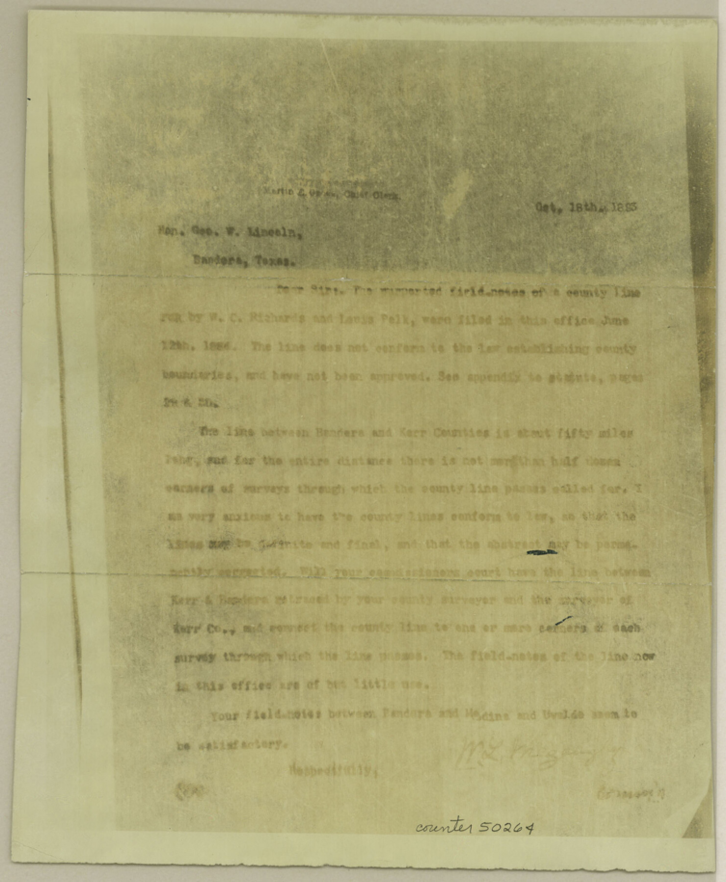
Bandera County Boundary File 2
-
Map/Doc
50264
-
Collection
General Map Collection
-
Counties
Bandera
-
Subjects
County Boundaries
-
Height x Width
9.1 x 7.5 inches
23.1 x 19.1 cm
Part of: General Map Collection
Montgomery County Sketch File 7

Print $35.00
- Digital $50.00
Montgomery County Sketch File 7
1861
Size 8.8 x 7.8 inches
Map/Doc 31785
Travis County Boundary File 29

Print $4.00
- Digital $50.00
Travis County Boundary File 29
Size 13.2 x 8.4 inches
Map/Doc 59467
Collingsworth County Working Sketch 6

Print $20.00
- Digital $50.00
Collingsworth County Working Sketch 6
1990
Size 37.7 x 41.8 inches
Map/Doc 68094
Presidio County Rolled Sketch 131A

Print $20.00
- Digital $50.00
Presidio County Rolled Sketch 131A
1992
Size 36.5 x 46.7 inches
Map/Doc 9802
Briscoe County Sketch File 11

Print $9.00
- Digital $50.00
Briscoe County Sketch File 11
Size 11.8 x 11.0 inches
Map/Doc 16422
Kinney County Boundary File 1a

Print $73.00
- Digital $50.00
Kinney County Boundary File 1a
Size 8.5 x 43.2 inches
Map/Doc 64946
Coast Chart No. 210 Aransas Pass and Corpus Christi Bay with the coast to latitude 27° 12' Texas

Print $20.00
- Digital $50.00
Coast Chart No. 210 Aransas Pass and Corpus Christi Bay with the coast to latitude 27° 12' Texas
1913
Size 27.5 x 18.3 inches
Map/Doc 72799
[Surveys between the Lavaca River and Arenosa Creek]
![3184, [Surveys between the Lavaca River and Arenosa Creek], General Map Collection](https://historictexasmaps.com/wmedia_w700/maps/3184.tif.jpg)
Print $20.00
- Digital $50.00
[Surveys between the Lavaca River and Arenosa Creek]
1840
Size 25.6 x 18.9 inches
Map/Doc 3184
Pecos County Working Sketch 81

Print $40.00
- Digital $50.00
Pecos County Working Sketch 81
1961
Size 35.4 x 49.7 inches
Map/Doc 71553
Pecos County Working Sketch 69

Print $40.00
- Digital $50.00
Pecos County Working Sketch 69
1956
Size 48.7 x 32.6 inches
Map/Doc 71541
Jim Wells County Working Sketch 7

Print $20.00
- Digital $50.00
Jim Wells County Working Sketch 7
1944
Size 26.2 x 29.3 inches
Map/Doc 66605
Van Zandt County Sketch File 19a

Print $4.00
- Digital $50.00
Van Zandt County Sketch File 19a
1858
Size 7.1 x 8.0 inches
Map/Doc 39424
You may also like
The Chief Justice County of Victoria. Lands in Conflict with Bexar and Gonzales Counties

Print $20.00
The Chief Justice County of Victoria. Lands in Conflict with Bexar and Gonzales Counties
2020
Size 23.3 x 21.7 inches
Map/Doc 96076
Wise County Sketch File 40

Print $4.00
- Digital $50.00
Wise County Sketch File 40
1875
Size 8.0 x 10.6 inches
Map/Doc 40597
Liberty County Sketch File 67

Print $28.00
- Digital $50.00
Liberty County Sketch File 67
1996
Size 11.3 x 8.8 inches
Map/Doc 30135
Cottle County Working Sketch 21

Print $20.00
- Digital $50.00
Cottle County Working Sketch 21
1982
Size 37.0 x 46.6 inches
Map/Doc 68331
Sterling County Sketch File 4

Print $20.00
- Digital $50.00
Sterling County Sketch File 4
1906
Size 19.4 x 26.0 inches
Map/Doc 12356
Shackelford County Sketch File 10

Print $20.00
- Digital $50.00
Shackelford County Sketch File 10
1918
Size 31.4 x 19.9 inches
Map/Doc 12316
General Highway Map, Stonewall County, Texas

Print $20.00
General Highway Map, Stonewall County, Texas
1940
Size 18.3 x 24.8 inches
Map/Doc 79249
Ward County Rolled Sketch 3

Print $40.00
- Digital $50.00
Ward County Rolled Sketch 3
Size 65.3 x 25.7 inches
Map/Doc 10101
[Redfish Bay, Aransas Pass, and part of Mustang Island]
![83009, [Redfish Bay, Aransas Pass, and part of Mustang Island], General Map Collection](https://historictexasmaps.com/wmedia_w700/maps/83009.tif.jpg)
Print $40.00
- Digital $50.00
[Redfish Bay, Aransas Pass, and part of Mustang Island]
1930
Size 51.0 x 46.5 inches
Map/Doc 83009
Hudspeth County Sketch File 20

Print $40.00
- Digital $50.00
Hudspeth County Sketch File 20
Size 37.1 x 57.3 inches
Map/Doc 10494
Hudspeth County Working Sketch 50

Print $20.00
- Digital $50.00
Hudspeth County Working Sketch 50
Size 24.6 x 37.2 inches
Map/Doc 66335
Galveston County Working Sketch 21

Print $20.00
- Digital $50.00
Galveston County Working Sketch 21
1987
Size 28.9 x 23.9 inches
Map/Doc 69358