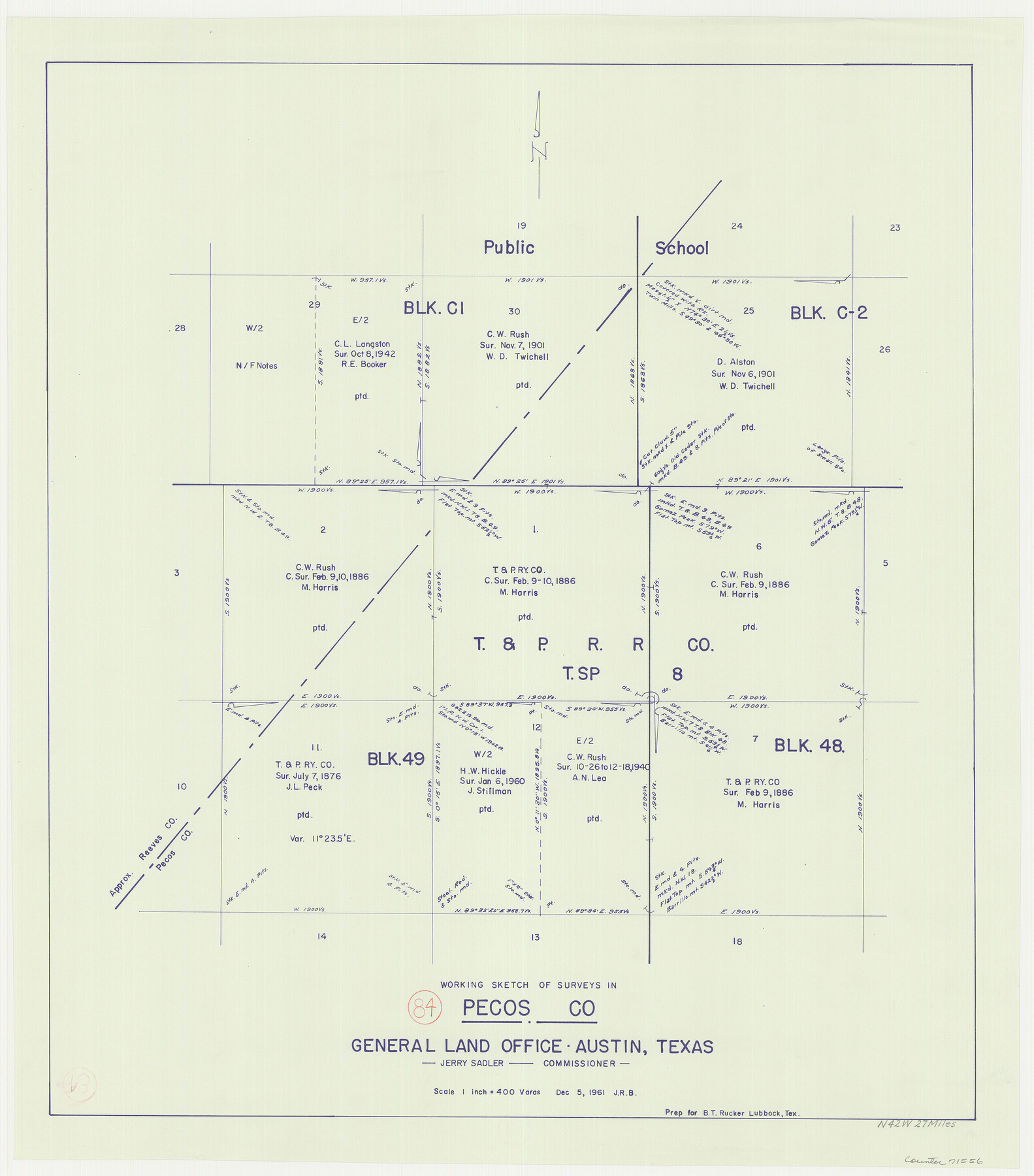
Pecos County Working Sketch 84
-
Map/Doc
71556
-
Collection
General Map Collection
-
Object Dates
12/5/1961 (Creation Date)
-
Counties
Pecos Reeves
-
Subjects
Surveying Working Sketch
-
Height x Width
26.1 x 23.0 inches
66.3 x 58.4 cm
-
Scale
1" = 400 varas
Part of: General Map Collection
Nolan County Working Sketch Graphic Index

Print $20.00
- Digital $50.00
Nolan County Working Sketch Graphic Index
1935
Size 41.6 x 36.9 inches
Map/Doc 76654
Hardin County Rolled Sketch TMH

Print $46.00
- Digital $50.00
Hardin County Rolled Sketch TMH
1936
Size 25.7 x 23.9 inches
Map/Doc 6093
Hill County Sketch File 20

Print $22.00
- Digital $50.00
Hill County Sketch File 20
1854
Size 8.3 x 7.7 inches
Map/Doc 26490
Jeff Davis County Working Sketch 46

Print $20.00
- Digital $50.00
Jeff Davis County Working Sketch 46
1991
Size 38.8 x 36.7 inches
Map/Doc 66541
Flight Mission No. DAH-9M, Frame 163, Orange County

Print $20.00
- Digital $50.00
Flight Mission No. DAH-9M, Frame 163, Orange County
1953
Size 18.4 x 22.4 inches
Map/Doc 86862
Travis County Appraisal District Plat Map 2_1002

Print $20.00
- Digital $50.00
Travis County Appraisal District Plat Map 2_1002
Size 21.4 x 26.5 inches
Map/Doc 94230
Live Oak County Working Sketch 31

Print $20.00
- Digital $50.00
Live Oak County Working Sketch 31
1991
Size 22.8 x 25.4 inches
Map/Doc 70616
Wichita County Working Sketch 19

Print $20.00
- Digital $50.00
Wichita County Working Sketch 19
1949
Size 18.1 x 30.9 inches
Map/Doc 72529
Fractional Township No. 7 South Range No. 2 West of the Indian Meridian, Indian Territory

Print $20.00
- Digital $50.00
Fractional Township No. 7 South Range No. 2 West of the Indian Meridian, Indian Territory
1898
Size 19.2 x 24.4 inches
Map/Doc 75195
[Surveys in Austin's Colony along the San Antonio Road and the Navasota River]
![202, [Surveys in Austin's Colony along the San Antonio Road and the Navasota River], General Map Collection](https://historictexasmaps.com/wmedia_w700/maps/202.tif.jpg)
Print $20.00
- Digital $50.00
[Surveys in Austin's Colony along the San Antonio Road and the Navasota River]
1833
Size 16.1 x 34.7 inches
Map/Doc 202

Robertson County Working Sketch 17

Print $20.00
- Digital $50.00
Robertson County Working Sketch 17
1991
Size 16.8 x 22.9 inches
Map/Doc 63590
You may also like
Crockett County Rolled Sketch 32

Print $20.00
- Digital $50.00
Crockett County Rolled Sketch 32
1930
Size 44.8 x 34.5 inches
Map/Doc 8697
Starr County Working Sketch 19

Print $20.00
- Digital $50.00
Starr County Working Sketch 19
1982
Size 27.3 x 33.9 inches
Map/Doc 63935
J. De Cordova's Map of the State of Texas Compiled from the records of the General Land Office of the State

Print $20.00
J. De Cordova's Map of the State of Texas Compiled from the records of the General Land Office of the State
1853
Size 35.0 x 35.0 inches
Map/Doc 88903
Wilbarger County Sketch File 8

Print $4.00
- Digital $50.00
Wilbarger County Sketch File 8
1885
Size 14.2 x 8.6 inches
Map/Doc 40179
Photo Index of Texas Coast - Sheet 2 of 6

Print $20.00
- Digital $50.00
Photo Index of Texas Coast - Sheet 2 of 6
1954
Size 20.0 x 24.0 inches
Map/Doc 83440
[Abstract Numbering Register - Real through Zavala]
![82968, [Abstract Numbering Register - Real through Zavala], General Map Collection](https://historictexasmaps.com/wmedia_w700/pdf_converted_jpg/qi_pdf_thumbnail_30615.jpg)
[Abstract Numbering Register - Real through Zavala]
Map/Doc 82968
Webb County Rolled Sketch 63

Print $20.00
- Digital $50.00
Webb County Rolled Sketch 63
1948
Size 39.4 x 37.0 inches
Map/Doc 10129
Harris County Working Sketch 53

Print $20.00
- Digital $50.00
Harris County Working Sketch 53
1948
Size 28.0 x 26.9 inches
Map/Doc 65945
Presidio County Working Sketch 144

Print $20.00
- Digital $50.00
Presidio County Working Sketch 144
1990
Size 20.4 x 26.6 inches
Map/Doc 71822
Floyd County Sketch File 16

Print $30.00
- Digital $50.00
Floyd County Sketch File 16
1913
Size 5.8 x 8.9 inches
Map/Doc 22742
New and Correct Map of the Great Rock Island Route - Chicago, Rock Island, & Pacific Railway

Print $20.00
- Digital $50.00
New and Correct Map of the Great Rock Island Route - Chicago, Rock Island, & Pacific Railway
1892
Size 20.0 x 42.2 inches
Map/Doc 95865
Flight Mission No. CRC-4R, Frame 109, Chambers County

Print $20.00
- Digital $50.00
Flight Mission No. CRC-4R, Frame 109, Chambers County
1956
Size 18.5 x 22.5 inches
Map/Doc 84906