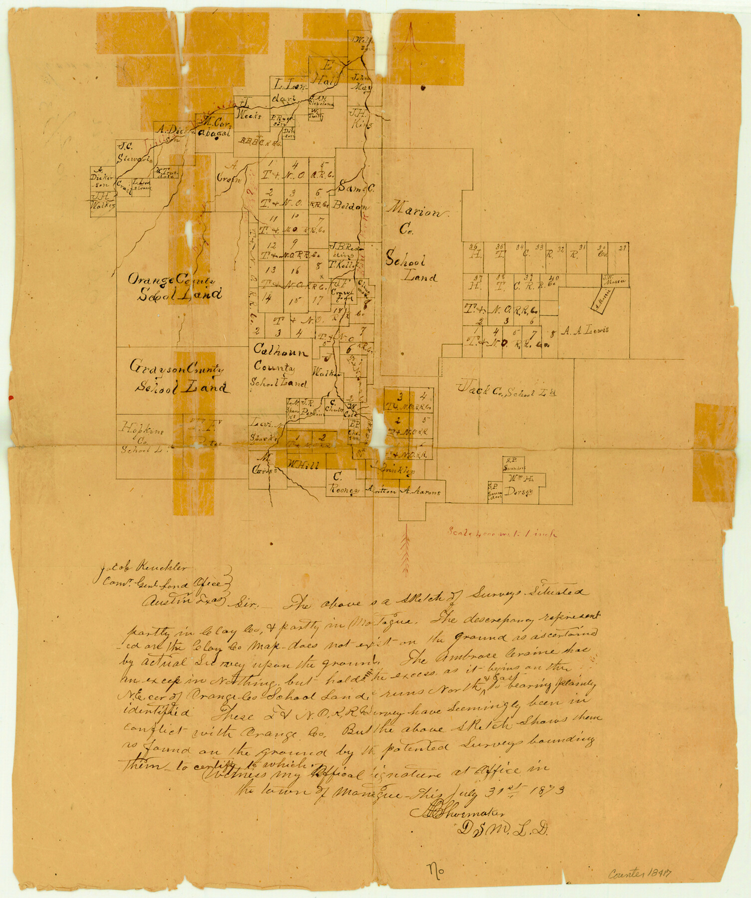
Clay County Sketch File 14
[Sketch of surveys south and east of Henrietta]
-
Map/Doc
18417
-
Collection
General Map Collection
-
Object Dates
1873/7/31 (Creation Date)
1873/9/2 (File Date)
-
People and Organizations
A.L. Shoemaker (Surveyor/Engineer)
-
Counties
Clay Montague
-
Subjects
Surveying Sketch File
-
Height x Width
16.5 x 13.8 inches
41.9 x 35.1 cm
-
Medium
paper, manuscript
-
Scale
1" = 4000 varas
-
Features
Little Wichita River
East Fork of Little Wichita River
Dry Fork of Little Wichita River
Part of: General Map Collection
Located Line of the Panhandle & Gulf Ry. through State Lands, Public School and University in Irion County, Texas

Print $20.00
- Digital $50.00
Located Line of the Panhandle & Gulf Ry. through State Lands, Public School and University in Irion County, Texas
1904
Size 12.1 x 27.5 inches
Map/Doc 64145
Nueces County NRC Article 33.136 Location Key Sheet

Print $20.00
- Digital $50.00
Nueces County NRC Article 33.136 Location Key Sheet
1975
Size 27.3 x 23.0 inches
Map/Doc 88587
Travis County Working Sketch 25

Print $20.00
- Digital $50.00
Travis County Working Sketch 25
1948
Size 26.4 x 32.0 inches
Map/Doc 69409
Dickens County

Print $20.00
- Digital $50.00
Dickens County
1915
Size 42.4 x 39.3 inches
Map/Doc 4722
Val Verde County Sketch File XXX3

Print $6.00
- Digital $50.00
Val Verde County Sketch File XXX3
Size 11.0 x 16.8 inches
Map/Doc 39096
Flight Mission No. CUG-3P, Frame 18, Kleberg County

Print $20.00
- Digital $50.00
Flight Mission No. CUG-3P, Frame 18, Kleberg County
1956
Size 18.5 x 22.3 inches
Map/Doc 86228
Flight Mission No. CGI-3N, Frame 96, Cameron County

Print $20.00
- Digital $50.00
Flight Mission No. CGI-3N, Frame 96, Cameron County
1954
Size 18.5 x 22.1 inches
Map/Doc 84576
Webb County Sketch File 55

Print $20.00
- Digital $50.00
Webb County Sketch File 55
1940
Size 20.6 x 12.6 inches
Map/Doc 12650
Reeves County Rolled Sketch 26

Print $20.00
- Digital $50.00
Reeves County Rolled Sketch 26
1985
Size 21.6 x 27.7 inches
Map/Doc 7495
Terry County Sketch File 13

Print $20.00
- Digital $50.00
Terry County Sketch File 13
Size 43.2 x 10.2 inches
Map/Doc 10397
Marion County Working Sketch 42

Print $20.00
- Digital $50.00
Marion County Working Sketch 42
2000
Size 29.6 x 41.4 inches
Map/Doc 70818
Angelina County Working Sketch 16

Print $20.00
- Digital $50.00
Angelina County Working Sketch 16
1935
Size 31.0 x 27.0 inches
Map/Doc 67097
You may also like
Bosque County Boundary File 11

Print $10.00
- Digital $50.00
Bosque County Boundary File 11
Size 8.8 x 7.0 inches
Map/Doc 50689
[Surveys along Elm Creek]
![347, [Surveys along Elm Creek], General Map Collection](https://historictexasmaps.com/wmedia_w700/maps/347.tif.jpg)
Print $2.00
- Digital $50.00
[Surveys along Elm Creek]
1846
Size 12.0 x 7.4 inches
Map/Doc 347
Brewster County Sketch File N-20

Print $40.00
- Digital $50.00
Brewster County Sketch File N-20
1941
Size 16.5 x 20.5 inches
Map/Doc 10967
Red River County Working Sketch 28

Print $20.00
- Digital $50.00
Red River County Working Sketch 28
1961
Size 28.1 x 38.7 inches
Map/Doc 72011
Flight Mission No. CGI-2N, Frame 152, Cameron County

Print $20.00
- Digital $50.00
Flight Mission No. CGI-2N, Frame 152, Cameron County
1954
Size 18.7 x 22.1 inches
Map/Doc 84534
[Sketch showing Blocks 2B, 3B, 3T, IT and 2]
![91843, [Sketch showing Blocks 2B, 3B, 3T, IT and 2], Twichell Survey Records](https://historictexasmaps.com/wmedia_w700/maps/91843-1.tif.jpg)
Print $20.00
- Digital $50.00
[Sketch showing Blocks 2B, 3B, 3T, IT and 2]
1918
Size 32.9 x 30.1 inches
Map/Doc 91843
Cooke County Sketch File 30

Print $4.00
- Digital $50.00
Cooke County Sketch File 30
Size 8.8 x 5.5 inches
Map/Doc 19291
McCulloch County Rolled Sketch 6

Print $20.00
- Digital $50.00
McCulloch County Rolled Sketch 6
1982
Size 27.9 x 33.9 inches
Map/Doc 6717
McLennan County Sketch File 21

Print $4.00
- Digital $50.00
McLennan County Sketch File 21
Size 9.0 x 8.2 inches
Map/Doc 31294
Right-of-Way and Track Map, Texas State Railroad operated by the T. and N. O. R.R. Co.

Print $40.00
- Digital $50.00
Right-of-Way and Track Map, Texas State Railroad operated by the T. and N. O. R.R. Co.
1917
Size 24.4 x 55.8 inches
Map/Doc 64174
[Midland County School Land, Martin County School Land, and vicinity]
![91128, [Midland County School Land, Martin County School Land, and vicinity], Twichell Survey Records](https://historictexasmaps.com/wmedia_w700/maps/91128-1.tif.jpg)
Print $2.00
- Digital $50.00
[Midland County School Land, Martin County School Land, and vicinity]
Size 9.0 x 11.4 inches
Map/Doc 91128
Travis County Appraisal District Plat Map 2_2915

Print $20.00
- Digital $50.00
Travis County Appraisal District Plat Map 2_2915
Size 21.5 x 26.4 inches
Map/Doc 94219