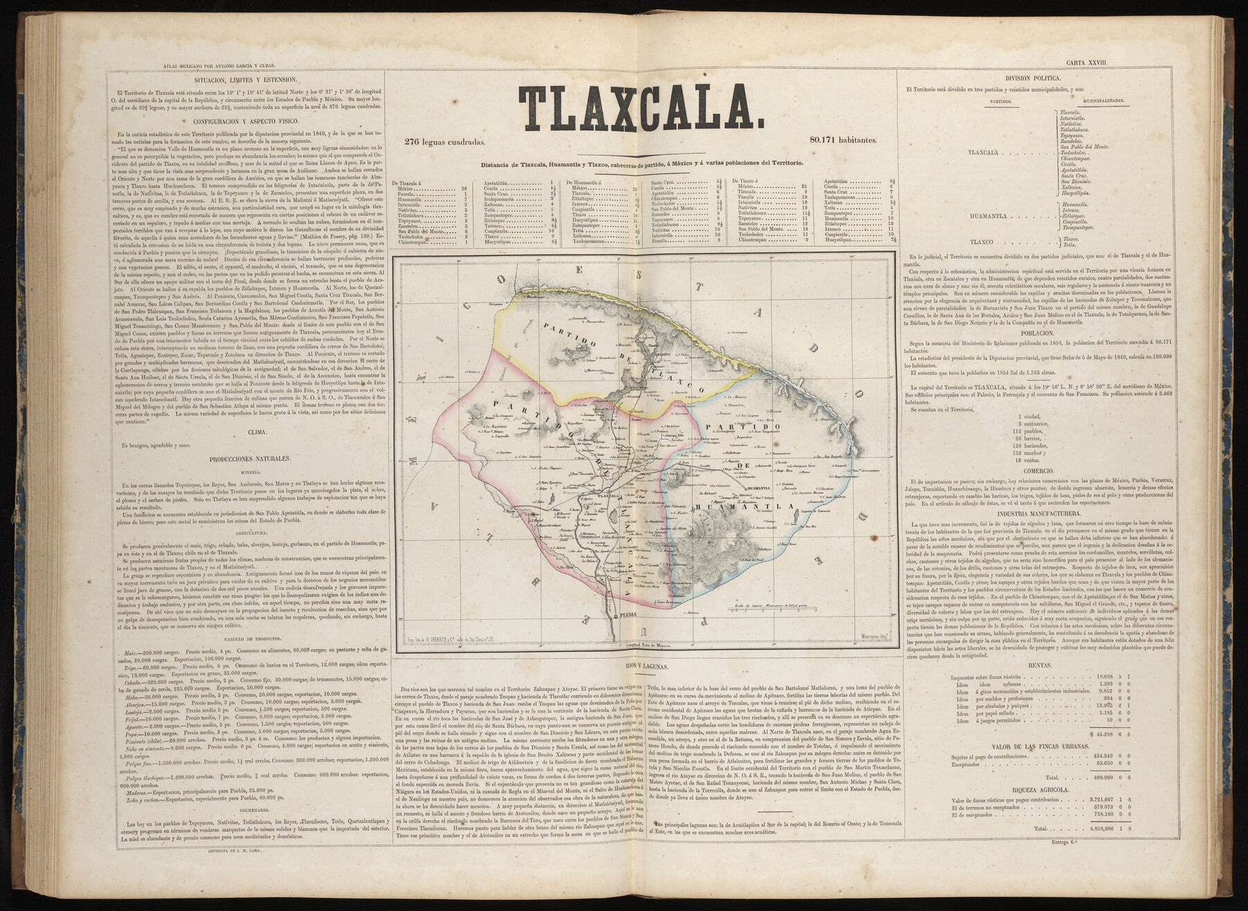
Tlaxcala
-
Map/Doc
97009
-
Collection
General Map Collection
-
Object Dates
1858 (Publication Date)
-
People and Organizations
Antonio García y Cubas (Cartographer)
-
Subjects
Atlas Mexico
-
Height x Width
22.8 x 31.3 inches
57.9 x 79.5 cm
-
Medium
paper, etching/engraving/lithograph
-
Comments
Map 28 of 32 from "Atlas Geografico, Estadistico e Historico de la Republica Mexicana" (95689)
Related maps
Atlas Geográfico, Estadístico é Histórico de la República Mexicana

Atlas Geográfico, Estadístico é Histórico de la República Mexicana
Map/Doc 95689
Part of: General Map Collection
Howard County Working Sketch 7b

Print $40.00
- Digital $50.00
Howard County Working Sketch 7b
1950
Size 83.3 x 25.6 inches
Map/Doc 66274
Harris County NRC Article 33.136 Sketch 4

Print $22.00
- Digital $50.00
Harris County NRC Article 33.136 Sketch 4
2001
Size 36.1 x 24.3 inches
Map/Doc 61600
Uvalde County Working Sketch 1

Print $20.00
- Digital $50.00
Uvalde County Working Sketch 1
1911
Size 27.3 x 21.0 inches
Map/Doc 72071
Map of Terry County

Print $20.00
- Digital $50.00
Map of Terry County
1902
Size 44.3 x 40.0 inches
Map/Doc 63062
Haskell County Sketch File 10

Print $8.00
- Digital $50.00
Haskell County Sketch File 10
Size 13.0 x 8.2 inches
Map/Doc 26136
Kimble County Working Sketch 46

Print $20.00
- Digital $50.00
Kimble County Working Sketch 46
1951
Size 29.3 x 18.9 inches
Map/Doc 70114
Chambers County Sketch File 18

Print $40.00
- Digital $50.00
Chambers County Sketch File 18
1879
Size 24.6 x 8.1 inches
Map/Doc 17569
City of Austin and Vicinity

Print $20.00
- Digital $50.00
City of Austin and Vicinity
1839
Size 20.4 x 19.6 inches
Map/Doc 3149
Cameron County Rolled Sketch 25

Print $20.00
- Digital $50.00
Cameron County Rolled Sketch 25
1977
Size 24.7 x 36.7 inches
Map/Doc 5795
Gaines County Sketch File 10

Print $40.00
- Digital $50.00
Gaines County Sketch File 10
Size 16.4 x 14.0 inches
Map/Doc 23193
Atascosa County Sketch File 29

Print $40.00
- Digital $50.00
Atascosa County Sketch File 29
Size 23.7 x 12.9 inches
Map/Doc 10863
United States - Gulf Coast Texas - Northern part of Laguna Madre

Print $20.00
- Digital $50.00
United States - Gulf Coast Texas - Northern part of Laguna Madre
1941
Size 26.7 x 18.3 inches
Map/Doc 72934
You may also like
Map of Voss, Texas, Coleman County

Print $20.00
- Digital $50.00
Map of Voss, Texas, Coleman County
Size 15.8 x 16.0 inches
Map/Doc 81519
Real County Working Sketch 51

Print $20.00
- Digital $50.00
Real County Working Sketch 51
1957
Size 28.1 x 24.1 inches
Map/Doc 71943
Map of Henderson County

Print $20.00
- Digital $50.00
Map of Henderson County
1877
Size 17.7 x 29.2 inches
Map/Doc 3666
Map of San Antonio Showing Original Townsite in Relation to Mission Valero

Map of San Antonio Showing Original Townsite in Relation to Mission Valero
2017
Size 11.0 x 8.5 inches
Map/Doc 94244
Red River County Working Sketch Graphic Index, Sheet 2 (Sketches 49 to Most Recent)

Print $20.00
- Digital $50.00
Red River County Working Sketch Graphic Index, Sheet 2 (Sketches 49 to Most Recent)
1934
Size 46.4 x 39.1 inches
Map/Doc 76681
Flight Mission No. BRE-1P, Frame 36, Nueces County

Print $20.00
- Digital $50.00
Flight Mission No. BRE-1P, Frame 36, Nueces County
1956
Size 18.3 x 22.2 inches
Map/Doc 86632
Dimmit County Sketch File 26

Print $6.00
- Digital $50.00
Dimmit County Sketch File 26
Size 13.5 x 10.2 inches
Map/Doc 21144
[Sketch of Runnels County School Land and vicinity]
![91666, [Sketch of Runnels County School Land and vicinity], Twichell Survey Records](https://historictexasmaps.com/wmedia_w700/maps/91666-1.tif.jpg)
Print $20.00
- Digital $50.00
[Sketch of Runnels County School Land and vicinity]
Size 17.3 x 15.3 inches
Map/Doc 91666
Gallup's Map of Texas

Print $20.00
- Digital $50.00
Gallup's Map of Texas
1920
Size 22.4 x 31.9 inches
Map/Doc 95696
Flight Mission No. BRE-2P, Frame 76, Nueces County

Print $20.00
- Digital $50.00
Flight Mission No. BRE-2P, Frame 76, Nueces County
1956
Size 18.4 x 22.4 inches
Map/Doc 86771
The Republic County of Galveston. January 20, 1841

Print $20.00
The Republic County of Galveston. January 20, 1841
2020
Size 14.7 x 21.9 inches
Map/Doc 96145
Swisher County Sketch File 1

Print $28.00
- Digital $50.00
Swisher County Sketch File 1
1884
Size 13.0 x 8.2 inches
Map/Doc 37566