Morris County Rolled Sketch 2A
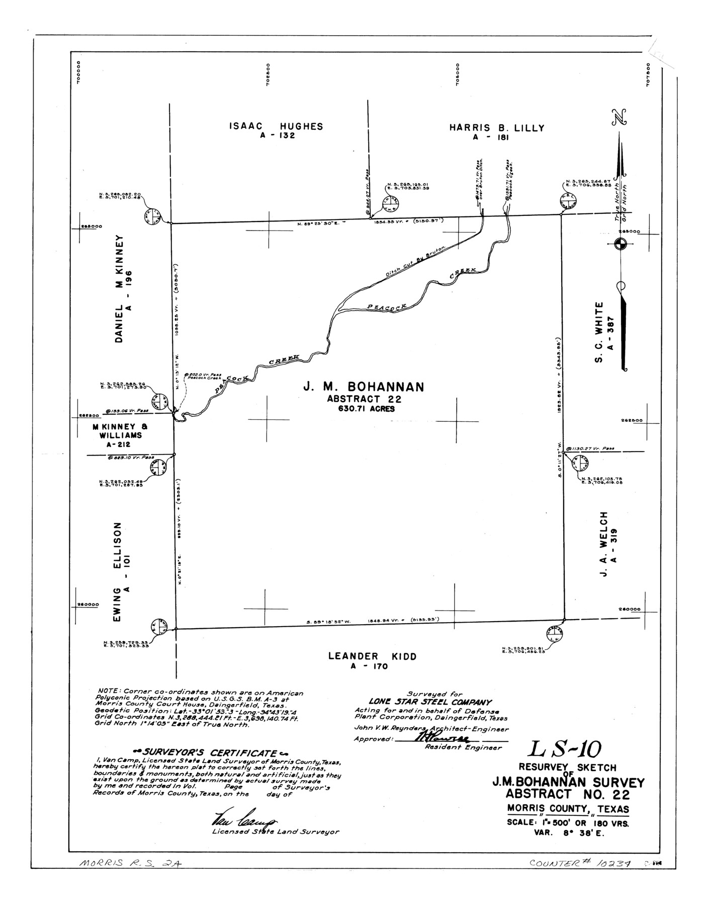
LS-10 - Resurvey sketch of J.M. Bohannan survey, abstract no. 22, Morris County, Texas
-
Map/Doc
10234
-
Collection
General Map Collection
-
People and Organizations
Van Camp (Surveyor/Engineer)
-
Counties
Morris
-
Subjects
Surveying Rolled Sketch
-
Height x Width
24.0 x 18.7 inches
61.0 x 47.5 cm
-
Medium
linen, manuscript
-
Scale
1" = 180 varas
-
Comments
See Morris County Rolled Sketch 2 (9550) for map of all retracement surveys made for Lone Star Steel Company.
Related maps
Morris County Rolled Sketch 2

Print $40.00
- Digital $50.00
Morris County Rolled Sketch 2
1944
Size 59.4 x 43.5 inches
Map/Doc 9550
Part of: General Map Collection
Flight Mission No. DQN-1K, Frame 123, Calhoun County

Print $20.00
- Digital $50.00
Flight Mission No. DQN-1K, Frame 123, Calhoun County
1953
Size 18.4 x 22.2 inches
Map/Doc 84189
Flight Mission No. DAG-22K, Frame 84, Matagorda County

Print $20.00
- Digital $50.00
Flight Mission No. DAG-22K, Frame 84, Matagorda County
1953
Size 15.7 x 15.6 inches
Map/Doc 86468
Official Map of the Highway System of Texas

Print $20.00
- Digital $50.00
Official Map of the Highway System of Texas
1936
Size 27.5 x 33.4 inches
Map/Doc 83598
Gregg County Sketch File 3

Print $6.00
- Digital $50.00
Gregg County Sketch File 3
1931
Size 11.2 x 8.7 inches
Map/Doc 24569
PSL Field Notes for Blocks 60, 61, 62, 83, 84, 85, 88, 89, 90, 91, 92, and 93 in Culberson County

PSL Field Notes for Blocks 60, 61, 62, 83, 84, 85, 88, 89, 90, 91, 92, and 93 in Culberson County
Map/Doc 81667
Aransas County Working Sketch 4

Print $20.00
- Digital $50.00
Aransas County Working Sketch 4
1928
Size 37.4 x 31.8 inches
Map/Doc 67171
Live Oak County Sketch File 27

Print $4.00
- Digital $50.00
Live Oak County Sketch File 27
1922
Size 14.3 x 8.7 inches
Map/Doc 30312
Goliad County Sketch File 1

Print $24.00
- Digital $50.00
Goliad County Sketch File 1
1857
Size 12.5 x 7.5 inches
Map/Doc 24211
Travis County Sketch File 74

Print $10.00
- Digital $50.00
Travis County Sketch File 74
1992
Size 11.5 x 8.8 inches
Map/Doc 38468
Hutchinson County Rolled Sketch 44-6

Print $20.00
- Digital $50.00
Hutchinson County Rolled Sketch 44-6
2002
Size 24.0 x 36.0 inches
Map/Doc 77542
Reeves County Working Sketch 50

Print $20.00
- Digital $50.00
Reeves County Working Sketch 50
1974
Size 45.3 x 30.4 inches
Map/Doc 63493
Upshur County Working Sketch 6

Print $20.00
- Digital $50.00
Upshur County Working Sketch 6
1943
Size 28.6 x 34.3 inches
Map/Doc 69562
You may also like
[Cotton Belt, St. Louis Southwestern Railway of Texas, Alignment through Smith County]
![64376, [Cotton Belt, St. Louis Southwestern Railway of Texas, Alignment through Smith County], General Map Collection](https://historictexasmaps.com/wmedia_w700/maps/64376-1.tif.jpg)
Print $20.00
- Digital $50.00
[Cotton Belt, St. Louis Southwestern Railway of Texas, Alignment through Smith County]
1903
Size 22.0 x 29.3 inches
Map/Doc 64376

"The Texas and Pacific Railway Company Reservation and Land Grant"

Print $38.00
- Digital $50.00
"The Texas and Pacific Railway Company Reservation and Land Grant"
1962
Size 9.3 x 6.5 inches
Map/Doc 62213
[McMullen and Live Oak County]
![10789, [McMullen and Live Oak County], General Map Collection](https://historictexasmaps.com/wmedia_w700/maps/10789.tif.jpg)
Print $20.00
- Digital $50.00
[McMullen and Live Oak County]
1870
Size 34.3 x 36.0 inches
Map/Doc 10789
Brazos Island Harbor, Texas - Dredging Entrance Channel Plan

Print $20.00
- Digital $50.00
Brazos Island Harbor, Texas - Dredging Entrance Channel Plan
1990
Size 14.5 x 19.9 inches
Map/Doc 83339
No. 1 - Survey for a road from the Brazo Santiago to the Rio Grande

Print $20.00
- Digital $50.00
No. 1 - Survey for a road from the Brazo Santiago to the Rio Grande
1847
Size 18.3 x 27.1 inches
Map/Doc 72877
Bell County Sketch File 31

Print $4.00
- Digital $50.00
Bell County Sketch File 31
1882
Size 8.0 x 8.9 inches
Map/Doc 14445
A Map of Louisiana and Mexico

Print $20.00
A Map of Louisiana and Mexico
1820
Size 43.0 x 32.6 inches
Map/Doc 76218
Angelina County Working Sketch 46

Print $20.00
- Digital $50.00
Angelina County Working Sketch 46
1976
Size 31.2 x 31.3 inches
Map/Doc 67129
Newton County Working Sketch 20

Print $20.00
- Digital $50.00
Newton County Working Sketch 20
1951
Size 22.7 x 15.7 inches
Map/Doc 71266
Navarro County Sketch File 12

Print $4.00
- Digital $50.00
Navarro County Sketch File 12
Size 7.0 x 7.0 inches
Map/Doc 32322
Galveston County Rolled Sketch 30

Print $20.00
- Digital $50.00
Galveston County Rolled Sketch 30
1979
Size 28.0 x 39.8 inches
Map/Doc 5964