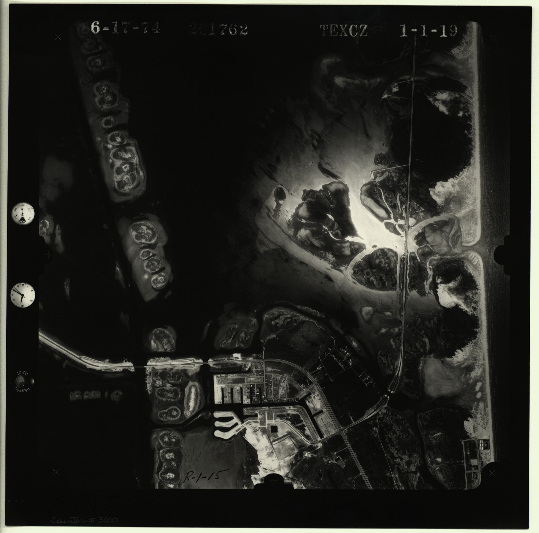
Packery Channel
-
Map/Doc
3000
-
Collection
General Map Collection
-
Object Dates
1974 (Creation Date)
-
People and Organizations
General Land Office (Publisher)
-
Counties
Nueces
-
Subjects
Aerial Photograph
-
Height x Width
10.2 x 10.3 inches
25.9 x 26.2 cm
-
Medium
contact print
-
Scale
N/A
-
Comments
Black and white aerial perspective.
Part of: General Map Collection
Red River County Sketch File 17

Print $26.00
- Digital $50.00
Red River County Sketch File 17
1868
Size 12.8 x 8.2 inches
Map/Doc 35141
Tom Green County Working Sketch 4

Print $20.00
- Digital $50.00
Tom Green County Working Sketch 4
1948
Size 42.5 x 34.1 inches
Map/Doc 69373
Atascosa County Working Sketch 27

Print $20.00
- Digital $50.00
Atascosa County Working Sketch 27
1963
Size 16.8 x 18.6 inches
Map/Doc 67223
Sabine and Neches Rivers

Print $20.00
- Digital $50.00
Sabine and Neches Rivers
1976
Size 19.8 x 44.9 inches
Map/Doc 69819

Young County Sketch File 12

Print $4.00
- Digital $50.00
Young County Sketch File 12
1889
Size 8.5 x 13.6 inches
Map/Doc 40876
Wise County Working Sketch 1

Print $20.00
- Digital $50.00
Wise County Working Sketch 1
1929
Size 22.4 x 19.4 inches
Map/Doc 72615
Map of Stephens Buchanan County north of the Clearfork of the Brazos River, Young- the balance Milam- Land- District

Print $20.00
- Digital $50.00
Map of Stephens Buchanan County north of the Clearfork of the Brazos River, Young- the balance Milam- Land- District
1859
Size 24.4 x 19.6 inches
Map/Doc 4052
Flight Mission No. DCL-7C, Frame 133, Kenedy County

Print $20.00
- Digital $50.00
Flight Mission No. DCL-7C, Frame 133, Kenedy County
1943
Size 15.4 x 15.2 inches
Map/Doc 86090
Flight Mission No. CUG-3P, Frame 31, Kleberg County

Print $20.00
- Digital $50.00
Flight Mission No. CUG-3P, Frame 31, Kleberg County
1956
Size 18.5 x 22.4 inches
Map/Doc 86236
Brewster County Rolled Sketch 95

Print $20.00
- Digital $50.00
Brewster County Rolled Sketch 95
1947
Size 29.4 x 38.0 inches
Map/Doc 5252
Andrews County Rolled Sketch 12

Print $40.00
- Digital $50.00
Andrews County Rolled Sketch 12
1933
Size 58.1 x 39.1 inches
Map/Doc 8390
You may also like
Harris County Rolled Sketch 70

Print $20.00
- Digital $50.00
Harris County Rolled Sketch 70
1942
Size 29.6 x 36.2 inches
Map/Doc 6110
Marion County Working Sketch 10

Print $20.00
- Digital $50.00
Marion County Working Sketch 10
1949
Size 30.9 x 30.2 inches
Map/Doc 70785
[PSL Block 1 along State line]
![90579, [PSL Block 1 along State line], Twichell Survey Records](https://historictexasmaps.com/wmedia_w700/maps/90579-1.tif.jpg)
Print $2.00
- Digital $50.00
[PSL Block 1 along State line]
Size 14.1 x 8.0 inches
Map/Doc 90579

Armstrong County Sketch File A-10

Print $40.00
- Digital $50.00
Armstrong County Sketch File A-10
Size 22.6 x 35.6 inches
Map/Doc 10852
Madison County Rolled Sketch 1

Print $20.00
- Digital $50.00
Madison County Rolled Sketch 1
1966
Size 36.7 x 46.0 inches
Map/Doc 9485
[Sketch of Leagues 458, 459, 474, 475, 480 and 481]
![91547, [Sketch of Leagues 458, 459, 474, 475, 480 and 481], Twichell Survey Records](https://historictexasmaps.com/wmedia_w700/maps/91547-1.tif.jpg)
Print $2.00
- Digital $50.00
[Sketch of Leagues 458, 459, 474, 475, 480 and 481]
Size 5.2 x 8.3 inches
Map/Doc 91547
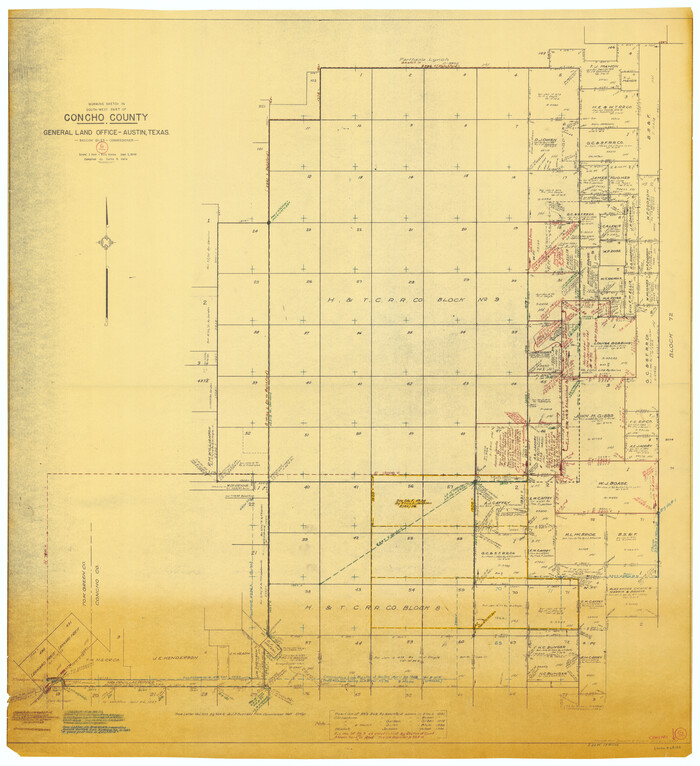
Concho County Working Sketch 6
Print $20.00
- Digital $50.00
Concho County Working Sketch 6
1948
Size 47.3 x 43.2 inches
Map/Doc 68188
Outer Continental Shelf Leasing Maps (Texas Offshore Operations)

Print $20.00
- Digital $50.00
Outer Continental Shelf Leasing Maps (Texas Offshore Operations)
Size 17.3 x 16.7 inches
Map/Doc 75841
Duval County Working Sketch 37

Print $20.00
- Digital $50.00
Duval County Working Sketch 37
1958
Size 23.3 x 37.1 inches
Map/Doc 68761
Taylor County Rolled Sketch 26

Print $20.00
- Digital $50.00
Taylor County Rolled Sketch 26
1982
Size 35.0 x 35.0 inches
Map/Doc 9987
Montgomery County Rolled Sketch 28

Print $20.00
- Digital $50.00
Montgomery County Rolled Sketch 28
1942
Size 35.1 x 22.6 inches
Map/Doc 6810