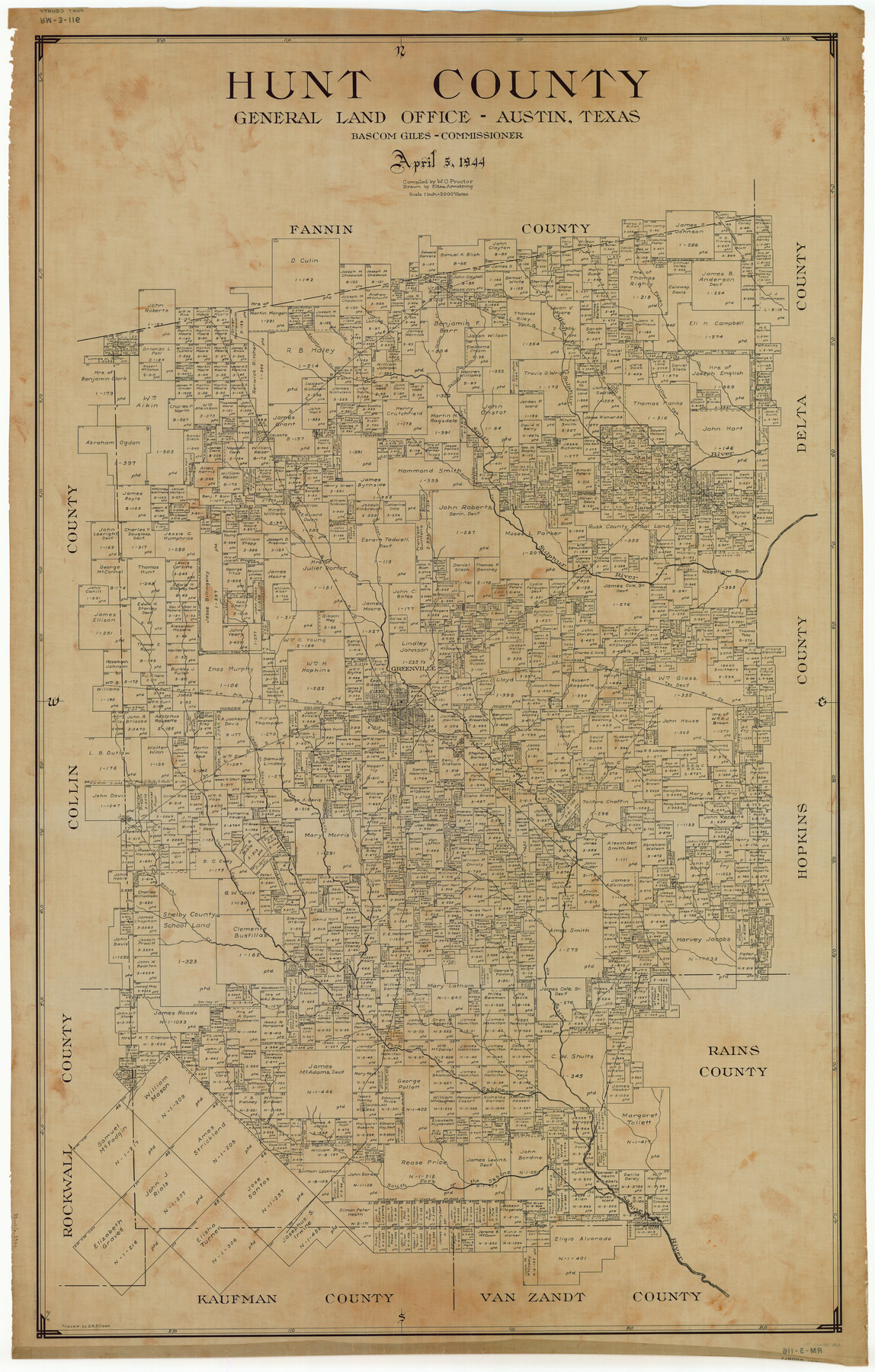
Hunt County
RM-3-116
-
Map/Doc
1862
-
Collection
General Map Collection
-
Object Dates
1944/4/5 (Creation Date)
-
People and Organizations
Texas General Land Office (Publisher)
William O. Proctor (Compiler)
Bascom Giles (GLO Commissioner)
Eltea Armstrong (Draftsman)
-
Counties
Hunt
-
Subjects
County
-
Height x Width
50.9 x 32.5 inches
129.3 x 82.6 cm
-
Comments
Traced by D. R. Ellison.
Part of: General Map Collection
Dimmit County Sketch File 10

Print $20.00
- Digital $50.00
Dimmit County Sketch File 10
Size 23.5 x 22.6 inches
Map/Doc 11338
Kerr County Working Sketch 10

Print $20.00
- Digital $50.00
Kerr County Working Sketch 10
1951
Size 22.3 x 16.0 inches
Map/Doc 70041
Crane County Working Sketch 14

Print $20.00
- Digital $50.00
Crane County Working Sketch 14
1946
Size 16.0 x 22.3 inches
Map/Doc 68291
Cass County Working Sketch 27

Print $20.00
- Digital $50.00
Cass County Working Sketch 27
1978
Size 17.5 x 19.7 inches
Map/Doc 67930
Blanco County Sketch File 27

Print $6.00
- Digital $50.00
Blanco County Sketch File 27
1888
Size 14.1 x 11.2 inches
Map/Doc 14621
Pecos County Working Sketch 78

Print $20.00
- Digital $50.00
Pecos County Working Sketch 78
1960
Size 29.4 x 34.4 inches
Map/Doc 71550
Blanco County Working Sketch 33

Print $40.00
- Digital $50.00
Blanco County Working Sketch 33
1978
Size 41.0 x 57.5 inches
Map/Doc 67393
Aransas County Sketch File 21

Print $2.00
- Digital $50.00
Aransas County Sketch File 21
Size 8.0 x 8.9 inches
Map/Doc 13157
Colorado County Working Sketch 6

Print $20.00
- Digital $50.00
Colorado County Working Sketch 6
1921
Size 15.4 x 14.3 inches
Map/Doc 68106
DeWitt County

Print $40.00
- Digital $50.00
DeWitt County
1987
Size 42.1 x 50.6 inches
Map/Doc 95481
Baylor County Sketch File 14

Print $4.00
- Digital $50.00
Baylor County Sketch File 14
1879
Size 13.0 x 8.2 inches
Map/Doc 14181
Newton County Boundary File 1

Print $4.00
- Digital $50.00
Newton County Boundary File 1
Size 14.3 x 8.8 inches
Map/Doc 57614
You may also like
Lampasas County Working Sketch 24

Print $20.00
- Digital $50.00
Lampasas County Working Sketch 24
Size 14.3 x 13.3 inches
Map/Doc 61796
Houston County Sketch File 22

Print $8.00
- Digital $50.00
Houston County Sketch File 22
1852
Size 12.6 x 8.2 inches
Map/Doc 26789
Right of Way and Track Map, the Missouri, Kansas and Texas Ry. of Texas - Henrietta Division

Print $20.00
- Digital $50.00
Right of Way and Track Map, the Missouri, Kansas and Texas Ry. of Texas - Henrietta Division
1918
Size 11.8 x 26.8 inches
Map/Doc 64755
[Blocks T, Y, C-39, A-1]
![92890, [Blocks T, Y, C-39, A-1], Twichell Survey Records](https://historictexasmaps.com/wmedia_w700/maps/92890-1.tif.jpg)
Print $3.00
- Digital $50.00
[Blocks T, Y, C-39, A-1]
1937
Size 12.5 x 10.2 inches
Map/Doc 92890
University of Texas System University Lands

Print $20.00
- Digital $50.00
University of Texas System University Lands
Size 23.2 x 17.6 inches
Map/Doc 93235
Kerr County Sketch File 14

Print $20.00
- Digital $50.00
Kerr County Sketch File 14
Size 14.9 x 17.8 inches
Map/Doc 11918
Map of Atascosa Co.

Print $40.00
- Digital $50.00
Map of Atascosa Co.
1894
Size 49.4 x 46.6 inches
Map/Doc 4794
Portion of Scurry County

Print $20.00
- Digital $50.00
Portion of Scurry County
1882
Size 35.1 x 25.3 inches
Map/Doc 92923
Spade Ranch Hockley County, Texas

Print $20.00
- Digital $50.00
Spade Ranch Hockley County, Texas
1948
Size 14.2 x 19.0 inches
Map/Doc 92225
General Highway Map Hockley County, Texas

Print $20.00
- Digital $50.00
General Highway Map Hockley County, Texas
1949
Size 25.7 x 18.8 inches
Map/Doc 92209
Bee County Boundary File 3

Print $20.00
- Digital $50.00
Bee County Boundary File 3
Size 22.3 x 16.2 inches
Map/Doc 50440
San Patricio County Sketch File 21

Print $6.00
San Patricio County Sketch File 21
1913
Size 10.3 x 13.7 inches
Map/Doc 36076