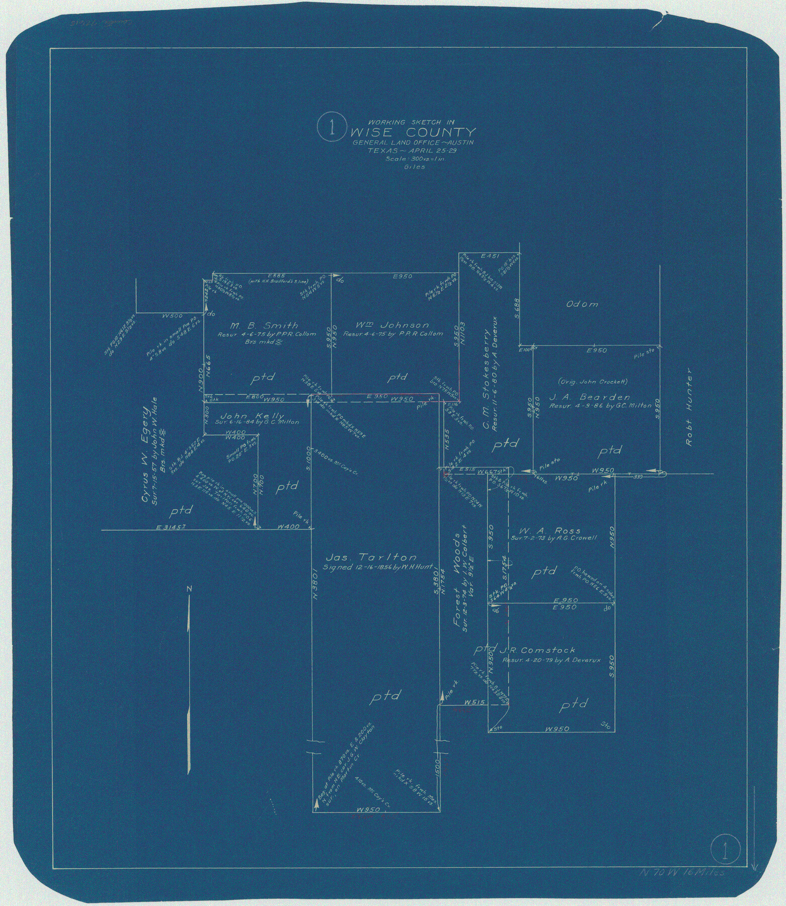
Wise County Working Sketch 1
-
Map/Doc
72615
-
Collection
General Map Collection
-
Object Dates
4/25/1929 (Creation Date)
-
People and Organizations
J. Bascom Giles (Draftsman)
-
Counties
Wise
-
Subjects
Surveying Working Sketch
-
Height x Width
22.4 x 19.4 inches
56.9 x 49.3 cm
-
Scale
1" = 300 varas
Part of: General Map Collection
Orange County Sketch File 9

Print $20.00
- Digital $50.00
Orange County Sketch File 9
1874
Size 12.7 x 22.9 inches
Map/Doc 12117
Hood County Sketch File 3

Print $4.00
- Digital $50.00
Hood County Sketch File 3
1877
Size 12.7 x 8.1 inches
Map/Doc 26573
[Miller Day Ranch]
![81517, [Miller Day Ranch], General Map Collection](https://historictexasmaps.com/wmedia_w700/maps/81517.tif.jpg)
Print $40.00
- Digital $50.00
[Miller Day Ranch]
1995
Size 60.6 x 38.0 inches
Map/Doc 81517
Map of the District of San Patricio and Nueces

Print $40.00
- Digital $50.00
Map of the District of San Patricio and Nueces
Size 93.8 x 67.5 inches
Map/Doc 1955
Motley County

Print $20.00
- Digital $50.00
Motley County
1914
Size 47.0 x 37.7 inches
Map/Doc 66946
Culberson County Sketch File 2

Print $20.00
- Digital $50.00
Culberson County Sketch File 2
1882
Size 28.9 x 36.4 inches
Map/Doc 11261
McMullen County Sketch File 7

Print $40.00
- Digital $50.00
McMullen County Sketch File 7
1859
Size 19.1 x 11.6 inches
Map/Doc 31347
Real County Working Sketch 76

Print $20.00
- Digital $50.00
Real County Working Sketch 76
1979
Size 30.6 x 21.1 inches
Map/Doc 71968
Brewster County Rolled Sketch 101

Print $40.00
- Digital $50.00
Brewster County Rolled Sketch 101
1927
Size 55.0 x 40.0 inches
Map/Doc 8509
Map of Hill County

Print $20.00
- Digital $50.00
Map of Hill County
1857
Size 21.5 x 25.6 inches
Map/Doc 3672
Revised Map of Matagorda Bay and Vicinity in Matagorda and Calhoun Counties showing subdivision for mineral development

Print $40.00
- Digital $50.00
Revised Map of Matagorda Bay and Vicinity in Matagorda and Calhoun Counties showing subdivision for mineral development
1941
Size 44.3 x 60.0 inches
Map/Doc 2933
Austin County Rolled Sketch 5B

Print $40.00
- Digital $50.00
Austin County Rolled Sketch 5B
Size 23.7 x 51.5 inches
Map/Doc 5107
You may also like
Jack County Sketch File 26

Print $4.00
- Digital $50.00
Jack County Sketch File 26
1891
Size 8.7 x 9.3 inches
Map/Doc 27563

Terrell County Working Sketch 84d

Print $20.00
- Digital $50.00
Terrell County Working Sketch 84d
1992
Size 18.4 x 31.5 inches
Map/Doc 69608
Glasscock County Working Sketch 8

Print $40.00
- Digital $50.00
Glasscock County Working Sketch 8
1955
Size 43.5 x 120.3 inches
Map/Doc 63181
Chart of the West Indies and Spanish Dominions in North America

Print $20.00
- Digital $50.00
Chart of the West Indies and Spanish Dominions in North America
1803
Size 25.3 x 38.4 inches
Map/Doc 97136
King County Boundary File 4

Print $58.00
- Digital $50.00
King County Boundary File 4
Size 14.1 x 8.7 inches
Map/Doc 64905
Frio County Sketch File 2

Print $8.00
- Digital $50.00
Frio County Sketch File 2
Size 8.2 x 7.8 inches
Map/Doc 23104
Erath County Working Sketch 38

Print $20.00
- Digital $50.00
Erath County Working Sketch 38
1974
Size 22.1 x 31.7 inches
Map/Doc 69119
Sketch of Colorado Co. presented by Mr. Mason

Print $2.00
- Digital $50.00
Sketch of Colorado Co. presented by Mr. Mason
1845
Size 14.3 x 8.2 inches
Map/Doc 69736
Wharton County Sketch File 13

Print $26.00
- Digital $50.00
Wharton County Sketch File 13
1894
Size 14.0 x 8.7 inches
Map/Doc 39935
Andrews County Rolled Sketch 12

Print $40.00
- Digital $50.00
Andrews County Rolled Sketch 12
1933
Size 58.1 x 39.1 inches
Map/Doc 8390
Map of the Southern part of Texas

Print $20.00
- Digital $50.00
Map of the Southern part of Texas
1831
Size 17.5 x 21.3 inches
Map/Doc 94442