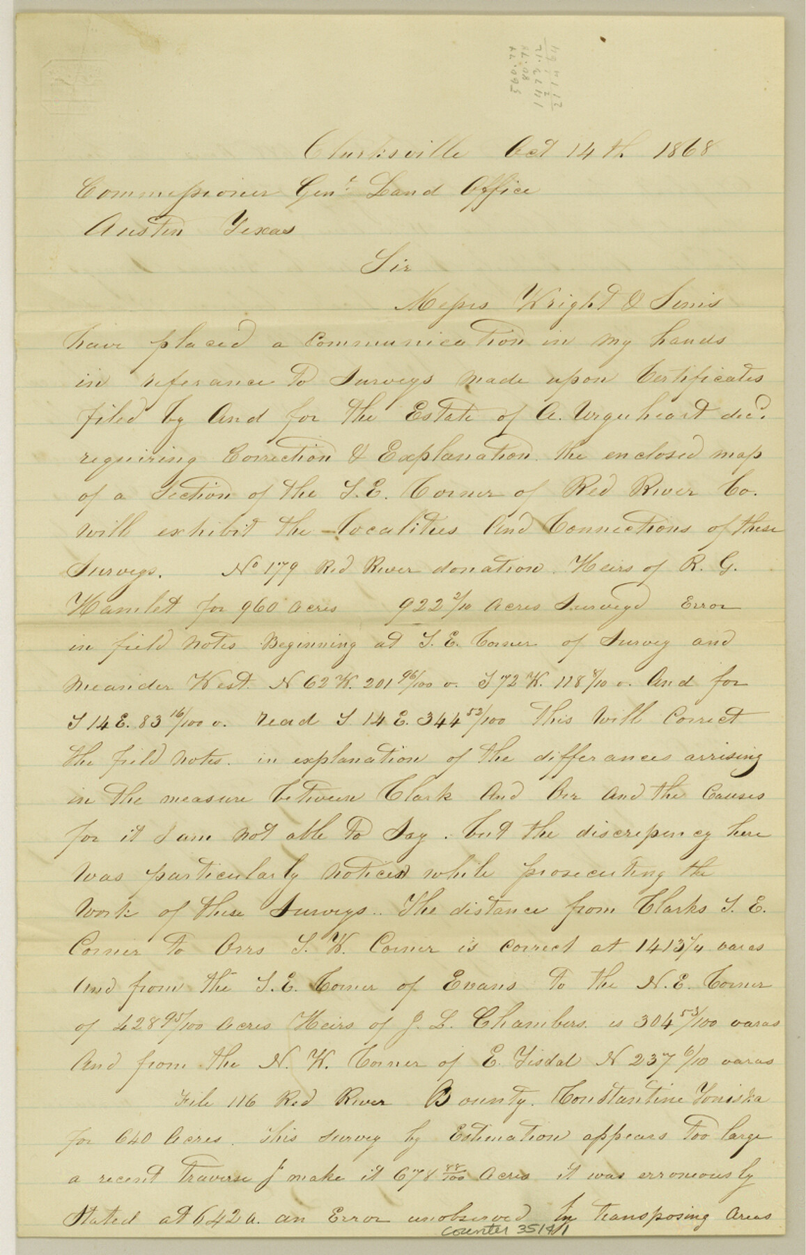
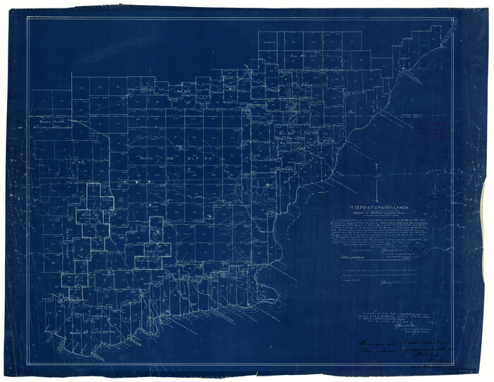
Red River County Sketch File 17
[Sketch and explanation of surveys in the southeast corner of the county]
-
Map/Doc
35141
-
Collection
General Map Collection
-
Object Dates
10/14/1868 (Creation Date)
10/26/1868 (File Date)
-
People and Organizations
Pheaton Johnson (Surveyor/Engineer)
-
Counties
Red River Bowie
-
Subjects
Surveying Sketch File
-
Height x Width
12.8 x 8.2 inches
32.5 x 20.8 cm
-
Medium
paper, manuscript
-
Scale
1" = 1000 varas
-
Features
Round Lake
Cut Hand Creek
Road to Culp Ferry
Shawnee Creek
Village Creek
Cany Creek
Shawnee Creek
Cedar Creek
Sulphor Fork of Red River
Timber Lake
Bois d'Arc Sloo [sic]
Part of: General Map Collection
Kerr County Rolled Sketch 10

Print $20.00
- Digital $50.00
Kerr County Rolled Sketch 10
1946
Size 20.7 x 26.2 inches
Map/Doc 6494

Gillespie County

Print $40.00
- Digital $50.00
Gillespie County
1887
Size 34.6 x 49.8 inches
Map/Doc 66836
Uvalde County Working Sketch 43

Print $20.00
- Digital $50.00
Uvalde County Working Sketch 43
1978
Size 29.3 x 27.7 inches
Map/Doc 72113
Schleicher County Sketch File 23

Print $20.00
- Digital $50.00
Schleicher County Sketch File 23
Size 29.1 x 24.6 inches
Map/Doc 12302
King County Working Sketch 6

Print $20.00
- Digital $50.00
King County Working Sketch 6
1944
Size 11.5 x 18.3 inches
Map/Doc 70170
Shelby County

Print $20.00
- Digital $50.00
Shelby County
1945
Size 39.1 x 44.2 inches
Map/Doc 77421
Castro County Working Sketch Graphic Index

Print $20.00
- Digital $50.00
Castro County Working Sketch Graphic Index
1932
Size 43.1 x 38.2 inches
Map/Doc 76490
New Map of Greater San Antonio

Print $20.00
- Digital $50.00
New Map of Greater San Antonio
1941
Size 24.5 x 19.7 inches
Map/Doc 95954
Jasper County Working Sketch 20

Print $20.00
- Digital $50.00
Jasper County Working Sketch 20
1940
Size 27.2 x 45.0 inches
Map/Doc 66482
Jim Wells County Sketch File 2

Print $6.00
- Digital $50.00
Jim Wells County Sketch File 2
1931
Size 11.1 x 8.7 inches
Map/Doc 28424
No. 2 Chart of Corpus Christi Pass, Texas

Print $20.00
- Digital $50.00
No. 2 Chart of Corpus Christi Pass, Texas
1878
Size 18.3 x 27.4 inches
Map/Doc 73020
You may also like
Flight Mission No. DQO-8K, Frame 132, Galveston County

Print $20.00
- Digital $50.00
Flight Mission No. DQO-8K, Frame 132, Galveston County
1952
Size 18.8 x 22.6 inches
Map/Doc 85197
[H. & T. C. Block 47 and part of G. & M. Block 3]
![91817, [H. & T. C. Block 47 and part of G. & M. Block 3], Twichell Survey Records](https://historictexasmaps.com/wmedia_w700/maps/91817-1.tif.jpg)
Print $20.00
- Digital $50.00
[H. & T. C. Block 47 and part of G. & M. Block 3]
Size 29.4 x 27.9 inches
Map/Doc 91817
Atascosa County Sketch File 27a

Print $4.00
- Digital $50.00
Atascosa County Sketch File 27a
Size 8.4 x 14.3 inches
Map/Doc 13799
Milam County Working Sketch 2

Print $20.00
- Digital $50.00
Milam County Working Sketch 2
1937
Size 20.2 x 20.5 inches
Map/Doc 71017
Moore County Rolled Sketch 13
Print $20.00
- Digital $50.00
Moore County Rolled Sketch 13
1920
Size 25.8 x 33.3 inches
Map/Doc 6829
Andrews County Working Sketch 29

Print $20.00
- Digital $50.00
Andrews County Working Sketch 29
1988
Size 25.9 x 25.8 inches
Map/Doc 67075
Amistad International Reservoir on Rio Grande 68

Print $20.00
- Digital $50.00
Amistad International Reservoir on Rio Grande 68
1949
Size 28.4 x 39.4 inches
Map/Doc 73353
Connected Map of Austin's Colony

Print $40.00
- Digital $50.00
Connected Map of Austin's Colony
1837
Size 93.2 x 43.7 inches
Map/Doc 93377
Smith County Working Sketch 4

Print $20.00
- Digital $50.00
Smith County Working Sketch 4
1913
Size 13.5 x 17.9 inches
Map/Doc 63889
Anderson County Sketch File 8

Print $4.00
- Digital $50.00
Anderson County Sketch File 8
1848
Size 5.8 x 8.0 inches
Map/Doc 12759
Frio County Working Sketch 25

Print $40.00
- Digital $50.00
Frio County Working Sketch 25
1989
Size 35.4 x 50.0 inches
Map/Doc 69299
Liberty County Sketch File 59

Print $6.00
- Digital $50.00
Liberty County Sketch File 59
1943
Size 14.2 x 8.8 inches
Map/Doc 30068