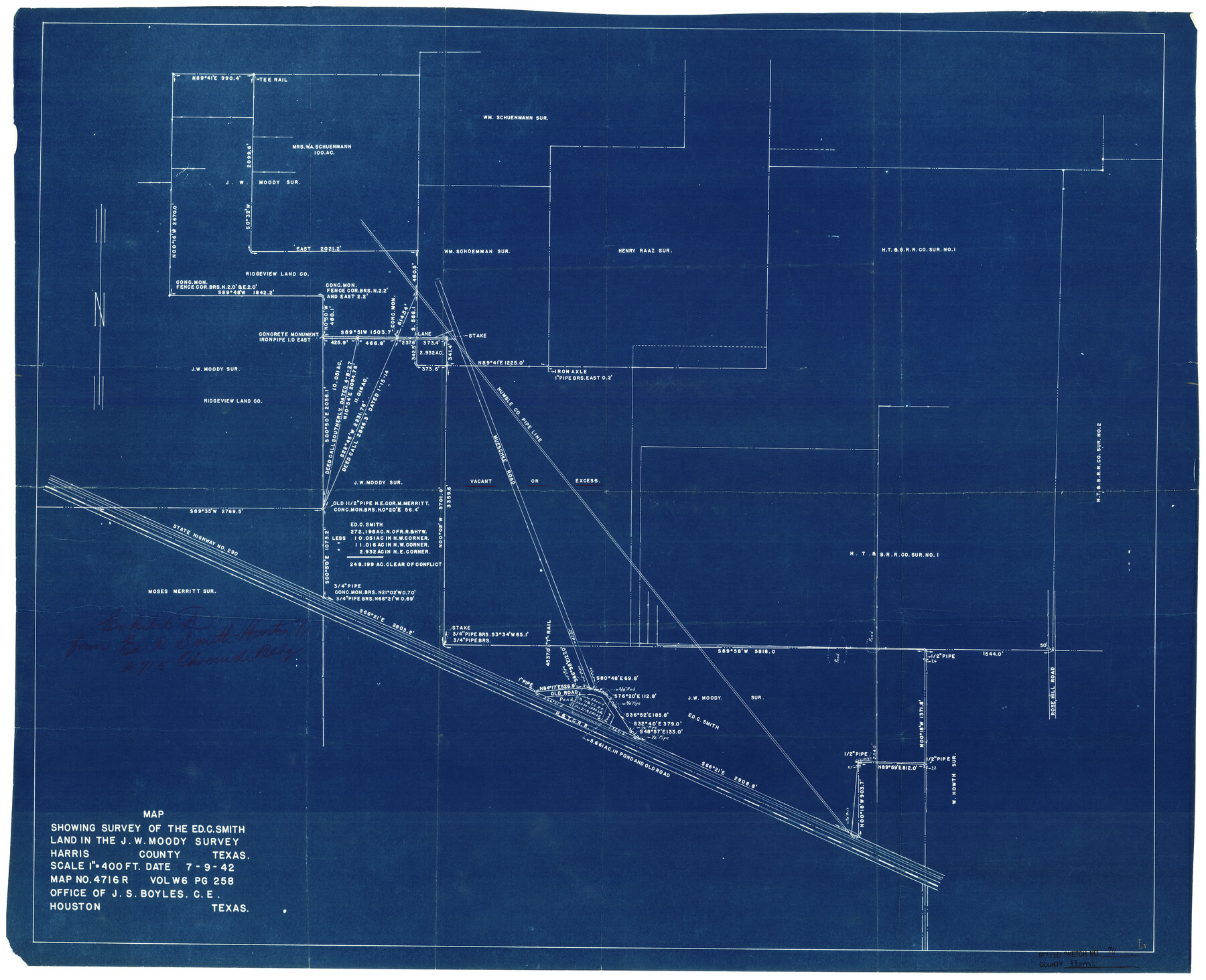
Harris County Rolled Sketch 70
Map showing survey of the Ed. C. Smith land in the J.W. Moody survey, Harris County, Texas
-
Map/Doc
6110
-
Collection
General Map Collection
-
Object Dates
7/9/1942 (Creation Date)
7/22/1942 (File Date)
-
People and Organizations
J.S. Boyles (Surveyor/Engineer)
-
Counties
Harris
-
Subjects
Surveying Rolled Sketch
-
Height x Width
29.6 x 36.2 inches
75.2 x 92.0 cm
-
Medium
blueprint/diazo
-
Scale
1" = 400 feet
Part of: General Map Collection
Duval County Sketch File 66

Print $12.00
- Digital $50.00
Duval County Sketch File 66
1944
Size 14.5 x 8.8 inches
Map/Doc 21444
Plat of South 1/2 of Colorado River Channel in McCulloch Co., Texas from Concho County line down river 34 mile 315 varas

Print $40.00
- Digital $50.00
Plat of South 1/2 of Colorado River Channel in McCulloch Co., Texas from Concho County line down river 34 mile 315 varas
1918
Size 41.1 x 144.3 inches
Map/Doc 76044
Aransas County NRC Article 33.136 Sketch 15

Print $42.00
- Digital $50.00
Aransas County NRC Article 33.136 Sketch 15
Size 24.0 x 36.0 inches
Map/Doc 95316
Presidio County Rolled Sketch 143

Print $20.00
- Digital $50.00
Presidio County Rolled Sketch 143
Size 40.2 x 36.8 inches
Map/Doc 90046
Bowie County Sketch File 6a

Print $8.00
- Digital $50.00
Bowie County Sketch File 6a
1927
Size 10.6 x 8.6 inches
Map/Doc 14844
[The S.K. Ry. of Texas, State Line to Pecos, Reeves Co., Texas]
![64160, [The S.K. Ry. of Texas, State Line to Pecos, Reeves Co., Texas], General Map Collection](https://historictexasmaps.com/wmedia_w700/maps/64160.tif.jpg)
Print $40.00
- Digital $50.00
[The S.K. Ry. of Texas, State Line to Pecos, Reeves Co., Texas]
1910
Size 19.5 x 119.7 inches
Map/Doc 64160

Matagorda County Boundary File 101

Print $10.00
- Digital $50.00
Matagorda County Boundary File 101
Size 8.9 x 7.4 inches
Map/Doc 56896
Runnels County Rolled Sketch 35

Print $20.00
- Digital $50.00
Runnels County Rolled Sketch 35
1950
Size 34.1 x 44.6 inches
Map/Doc 7523
Van Zandt County Sketch File A45

Print $40.00
- Digital $50.00
Van Zandt County Sketch File A45
Size 14.2 x 13.7 inches
Map/Doc 39501
Brewster County Rolled Sketch 104

Print $40.00
- Digital $50.00
Brewster County Rolled Sketch 104
1938
Size 68.3 x 45.3 inches
Map/Doc 8511
Flight Mission No. CRC-3R, Frame 52, Chambers County

Print $20.00
- Digital $50.00
Flight Mission No. CRC-3R, Frame 52, Chambers County
1956
Size 18.7 x 22.3 inches
Map/Doc 89041
You may also like
Flight Mission No. BRE-2P, Frame 64, Nueces County

Print $20.00
- Digital $50.00
Flight Mission No. BRE-2P, Frame 64, Nueces County
1956
Size 18.5 x 22.6 inches
Map/Doc 86759
Sutton County Sketch File 62

Print $4.00
- Digital $50.00
Sutton County Sketch File 62
1959
Size 3.7 x 8.6 inches
Map/Doc 37564
[Scripture Addition to the City of Denton]
![90587, [Scripture Addition to the City of Denton], Twichell Survey Records](https://historictexasmaps.com/wmedia_w700/maps/90587-1.tif.jpg)
Print $20.00
- Digital $50.00
[Scripture Addition to the City of Denton]
Size 27.3 x 22.0 inches
Map/Doc 90587
Starr County Sketch File 26

Print $20.00
- Digital $50.00
Starr County Sketch File 26
1923
Size 31.7 x 27.2 inches
Map/Doc 10607
General Highway Map, Bastrop County, Texas

Print $20.00
General Highway Map, Bastrop County, Texas
1940
Size 18.6 x 25.2 inches
Map/Doc 79012
El Paso County

Print $20.00
- Digital $50.00
El Paso County
1875
Size 26.3 x 28.8 inches
Map/Doc 3512
Borden County Working Sketch 9

Print $20.00
- Digital $50.00
Borden County Working Sketch 9
1951
Size 24.8 x 42.3 inches
Map/Doc 67469
Cooke County Boundary File 19

Print $30.00
- Digital $50.00
Cooke County Boundary File 19
Size 8.7 x 4.0 inches
Map/Doc 51858
Bastrop County Sketch File 13

Print $6.00
- Digital $50.00
Bastrop County Sketch File 13
1845
Size 10.1 x 15.8 inches
Map/Doc 14070
Henderson County Working Sketch 3

Print $20.00
- Digital $50.00
Henderson County Working Sketch 3
Size 28.5 x 38.3 inches
Map/Doc 66136
Nueces County Sketch File 25a

Print $6.00
- Digital $50.00
Nueces County Sketch File 25a
1890
Size 14.2 x 8.4 inches
Map/Doc 32578
Austin County Working Sketch 2

Print $20.00
- Digital $50.00
Austin County Working Sketch 2
1944
Size 23.3 x 27.0 inches
Map/Doc 67243