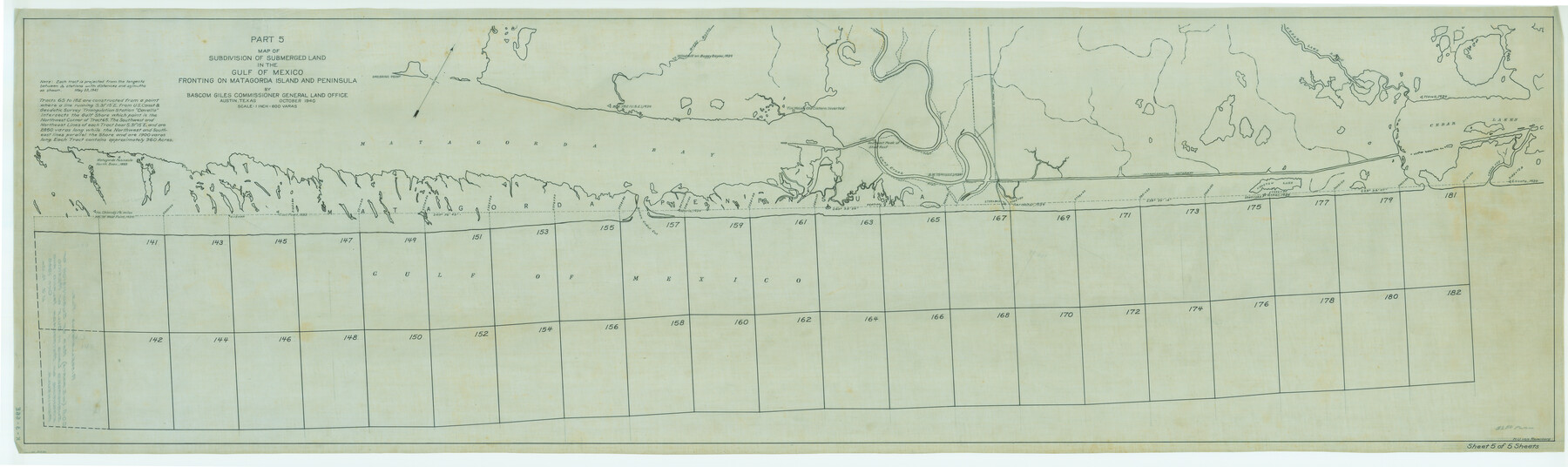
Map of subdivision of submerged land in the Gulf of Mexico fronting on Matagorda Island and Peninsula
K-3-66
-
Map/Doc
2932
-
Collection
General Map Collection
-
Object Dates
1940 (Creation Date)
-
People and Organizations
General Land Office (Publisher)
-
Subjects
Energy Offshore Submerged Area
-
Height x Width
22.8 x 76.5 inches
57.9 x 194.3 cm
Part of: General Map Collection
Jeff Davis County Rolled Sketch 46

Print $134.00
- Digital $50.00
Jeff Davis County Rolled Sketch 46
2006
Size 17.5 x 24.0 inches
Map/Doc 87213
Liberty County Working Sketch 83

Print $40.00
- Digital $50.00
Liberty County Working Sketch 83
1981
Size 68.4 x 37.8 inches
Map/Doc 70543
Flight Mission No. BRE-1P, Frame 6, Nueces County

Print $20.00
- Digital $50.00
Flight Mission No. BRE-1P, Frame 6, Nueces County
1956
Size 18.2 x 22.1 inches
Map/Doc 86614
Map of the Fort Worth and Denver City Railway, through Wilbarger County Texas, 1882

Print $40.00
- Digital $50.00
Map of the Fort Worth and Denver City Railway, through Wilbarger County Texas, 1882
Size 22.6 x 79.4 inches
Map/Doc 64427
Nueces County Rolled Sketch M-12

Print $20.00
- Digital $50.00
Nueces County Rolled Sketch M-12
1913
Size 24.9 x 40.0 inches
Map/Doc 7171
[Sketch for Mineral Application 24072, San Jacinto River]
![65605, [Sketch for Mineral Application 24072, San Jacinto River], General Map Collection](https://historictexasmaps.com/wmedia_w700/maps/65605.tif.jpg)
Print $20.00
- Digital $50.00
[Sketch for Mineral Application 24072, San Jacinto River]
1929
Size 23.4 x 17.8 inches
Map/Doc 65605
Webb County Working Sketch 67

Print $40.00
- Digital $50.00
Webb County Working Sketch 67
1966
Size 60.9 x 43.7 inches
Map/Doc 72434
Hunt County Boundary File 11a

Print $15.00
- Digital $50.00
Hunt County Boundary File 11a
Size 11.1 x 8.9 inches
Map/Doc 55272
Brooks County Working Sketch 3

Print $20.00
- Digital $50.00
Brooks County Working Sketch 3
Size 16.2 x 21.3 inches
Map/Doc 67787
Marion County Sketch File 1a

Print $3.00
- Digital $50.00
Marion County Sketch File 1a
1867
Size 17.4 x 7.7 inches
Map/Doc 30559
Map of Chocolate Bay, west portion of West Bay & vicinity, Brazoria & Galveston Counties showing subdivision for mineral development

Print $40.00
- Digital $50.00
Map of Chocolate Bay, west portion of West Bay & vicinity, Brazoria & Galveston Counties showing subdivision for mineral development
Size 42.0 x 58.1 inches
Map/Doc 65806
Tyler County Sketch File 31

Print $10.00
- Digital $50.00
Tyler County Sketch File 31
1941
Size 14.3 x 9.0 inches
Map/Doc 38723
You may also like
The Chief Justice County of Colorado. Lands in Conflict with Brazoria, Mina Counties

Print $20.00
The Chief Justice County of Colorado. Lands in Conflict with Brazoria, Mina Counties
2020
Size 14.8 x 21.7 inches
Map/Doc 96045
Cherokee County Sketch File 2

Print $6.00
- Digital $50.00
Cherokee County Sketch File 2
1857
Size 8.2 x 7.9 inches
Map/Doc 18112
Map of section no. 8 of a survey of Padre Island made for the Office of the Attorney General of the State of Texas

Print $40.00
- Digital $50.00
Map of section no. 8 of a survey of Padre Island made for the Office of the Attorney General of the State of Texas
1941
Size 56.2 x 40.3 inches
Map/Doc 2264
San Augustine County Working Sketch 11a

Print $20.00
- Digital $50.00
San Augustine County Working Sketch 11a
Size 18.8 x 24.4 inches
Map/Doc 63698
[Worksheets related to the Wilson Strickland survey and vicinity]
![91302, [Worksheets related to the Wilson Strickland survey and vicinity], Twichell Survey Records](https://historictexasmaps.com/wmedia_w700/maps/91302-1.tif.jpg)
Print $20.00
- Digital $50.00
[Worksheets related to the Wilson Strickland survey and vicinity]
Size 22.0 x 25.6 inches
Map/Doc 91302
Crockett County Sketch File 74

Print $22.00
- Digital $50.00
Crockett County Sketch File 74
1933
Size 11.4 x 8.6 inches
Map/Doc 19872
Bastrop County

Print $40.00
- Digital $50.00
Bastrop County
1917
Size 48.0 x 40.5 inches
Map/Doc 4881
Map of Asia engraved to illustrate Mitchell's school and family geography (Inset: Map of Palestine or the Holy Land)

Print $20.00
- Digital $50.00
Map of Asia engraved to illustrate Mitchell's school and family geography (Inset: Map of Palestine or the Holy Land)
1839
Size 9.5 x 11.8 inches
Map/Doc 93506
Maps of Gulf Intracoastal Waterway, Texas - Sabine River to the Rio Grande and connecting waterways including ship channels

Print $20.00
- Digital $50.00
Maps of Gulf Intracoastal Waterway, Texas - Sabine River to the Rio Grande and connecting waterways including ship channels
1966
Size 14.6 x 22.2 inches
Map/Doc 61947
Tom Green County Sketch File 15

Print $6.00
- Digital $50.00
Tom Green County Sketch File 15
1880
Size 13.3 x 10.9 inches
Map/Doc 38172
Atascosa County Sketch File 1

Print $8.00
- Digital $50.00
Atascosa County Sketch File 1
Size 8.1 x 6.1 inches
Map/Doc 13718
Presidio County Rolled Sketch 30

Print $40.00
- Digital $50.00
Presidio County Rolled Sketch 30
Size 40.8 x 84.9 inches
Map/Doc 9767