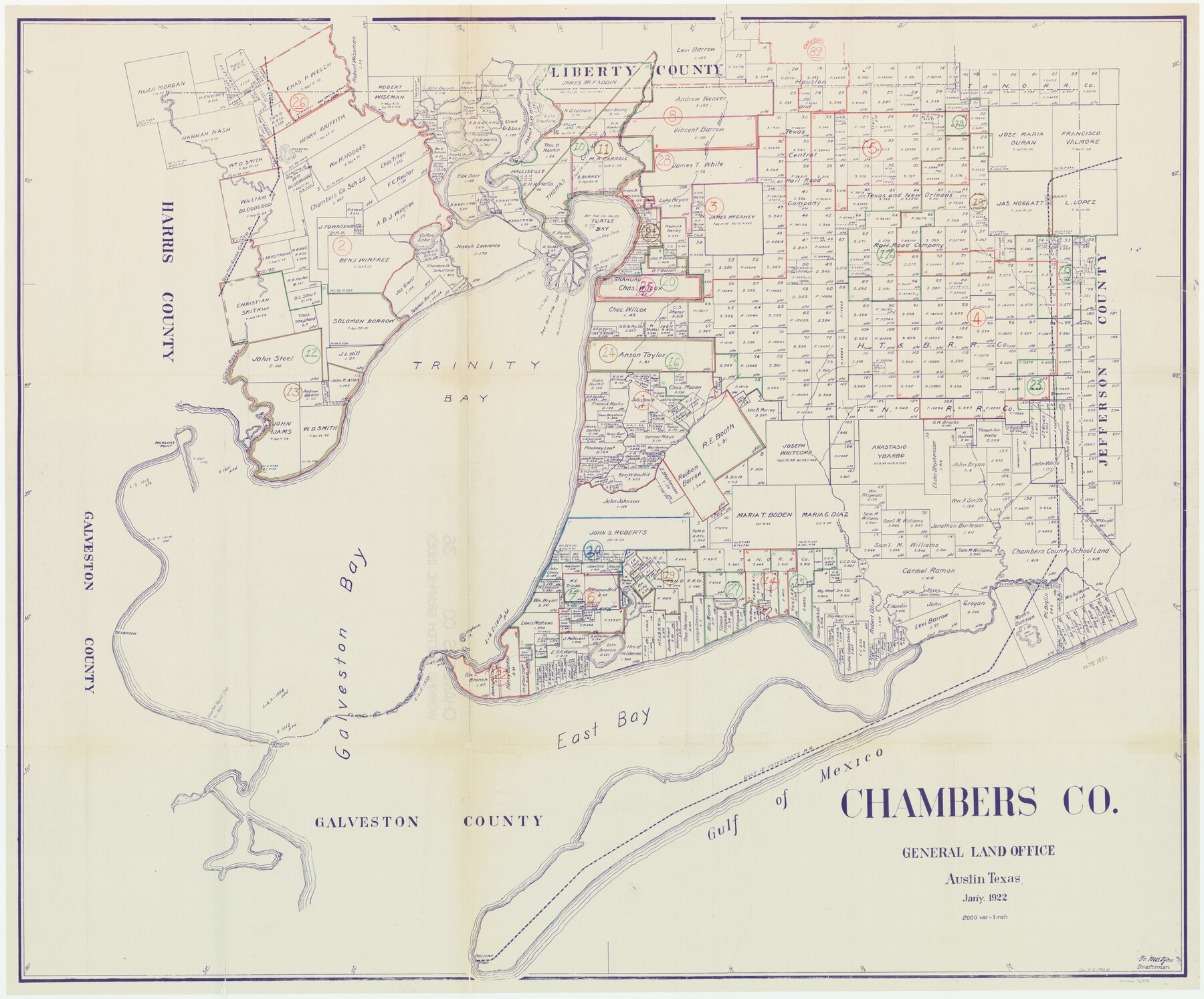
Chambers County Working Sketch Graphic Index
-
Map/Doc
76491
-
Collection
General Map Collection
-
Object Dates
1/1922 (Creation Date)
-
People and Organizations
Fr. Matzow (Draftsman)
-
Counties
Chambers
-
Subjects
County Surveying Working Sketch
-
Height x Width
39.3 x 47.3 inches
99.8 x 120.1 cm
-
Scale
1" = 2000 varas
Part of: General Map Collection
Flight Mission No. BQR-20K, Frame 9, Brazoria County

Print $20.00
- Digital $50.00
Flight Mission No. BQR-20K, Frame 9, Brazoria County
1952
Size 18.6 x 22.4 inches
Map/Doc 84111
La Salle County Working Sketch 29

Print $20.00
- Digital $50.00
La Salle County Working Sketch 29
1955
Size 25.8 x 27.4 inches
Map/Doc 70330
Nueces County Sketch File 26

Print $40.00
- Digital $50.00
Nueces County Sketch File 26
1890
Size 26.7 x 23.2 inches
Map/Doc 42184
Robertson County Working Sketch 12

Print $20.00
- Digital $50.00
Robertson County Working Sketch 12
1984
Size 20.6 x 22.4 inches
Map/Doc 63585
Williamson County Sketch File 25

Print $14.00
- Digital $50.00
Williamson County Sketch File 25
1878
Size 8.9 x 8.3 inches
Map/Doc 40361
Flight Mission No. DQN-2K, Frame 93, Calhoun County

Print $20.00
- Digital $50.00
Flight Mission No. DQN-2K, Frame 93, Calhoun County
1953
Size 16.5 x 16.2 inches
Map/Doc 84283
Jefferson County Working Sketch 24

Print $20.00
- Digital $50.00
Jefferson County Working Sketch 24
1977
Size 28.4 x 44.5 inches
Map/Doc 66567
Nueces County Rolled Sketch 127

Print $20.00
- Digital $50.00
Nueces County Rolled Sketch 127
1998
Size 24.1 x 36.4 inches
Map/Doc 7162
North Sulphur River, Mt. Joy Sheet

Print $20.00
- Digital $50.00
North Sulphur River, Mt. Joy Sheet
1926
Size 33.7 x 40.9 inches
Map/Doc 65166
Hays County Rolled Sketch 32

Print $20.00
- Digital $50.00
Hays County Rolled Sketch 32
2003
Size 15.6 x 20.0 inches
Map/Doc 78489
Mirando City, Webb County, Texas

Print $40.00
- Digital $50.00
Mirando City, Webb County, Texas
1937
Size 60.0 x 36.2 inches
Map/Doc 10132
McCulloch County Sketch File 5

Print $11.00
- Digital $50.00
McCulloch County Sketch File 5
1899
Size 17.5 x 9.2 inches
Map/Doc 31177
You may also like
Harris County Sketch File 23

Print $4.00
- Digital $50.00
Harris County Sketch File 23
Size 8.5 x 6.2 inches
Map/Doc 25377
Map of Jefferson County Texas

Print $20.00
- Digital $50.00
Map of Jefferson County Texas
1879
Size 23.3 x 20.6 inches
Map/Doc 3729
Butt's Map of Cooke County, Texas

Print $20.00
Butt's Map of Cooke County, Texas
1888
Size 17.5 x 14.5 inches
Map/Doc 88920
Panola County Sketch File 28

Print $20.00
- Digital $50.00
Panola County Sketch File 28
1859
Size 22.8 x 22.2 inches
Map/Doc 12142
Chambers County Sketch File 53

Print $12.00
- Digital $50.00
Chambers County Sketch File 53
1952
Size 14.3 x 8.9 inches
Map/Doc 18087
[I. & G. N. RR. Co. Block I]
![89828, [I. &G. N. RR. Co. Block I], Twichell Survey Records](https://historictexasmaps.com/wmedia_w700/maps/89828-1.tif.jpg)
Print $20.00
- Digital $50.00
[I. & G. N. RR. Co. Block I]
Size 43.0 x 31.7 inches
Map/Doc 89828
Rusk County Sketch File 37

Print $20.00
Rusk County Sketch File 37
1951
Size 23.3 x 26.2 inches
Map/Doc 12275
Shelby County Sketch File 33

Print $8.00
- Digital $50.00
Shelby County Sketch File 33
1949
Size 11.5 x 9.0 inches
Map/Doc 36670
Map of Coleman County

Print $20.00
- Digital $50.00
Map of Coleman County
1895
Size 26.1 x 18.9 inches
Map/Doc 3415
Live Oak County Working Sketch 24

Print $20.00
- Digital $50.00
Live Oak County Working Sketch 24
1978
Size 31.9 x 38.2 inches
Map/Doc 70609
Andrews County Sketch File 10

Print $40.00
- Digital $50.00
Andrews County Sketch File 10
1950
Size 27.4 x 18.2 inches
Map/Doc 10810
Edwards County Sketch File 35

Print $4.00
- Digital $50.00
Edwards County Sketch File 35
Size 11.3 x 8.9 inches
Map/Doc 21769