Chambers County Sketch File 20
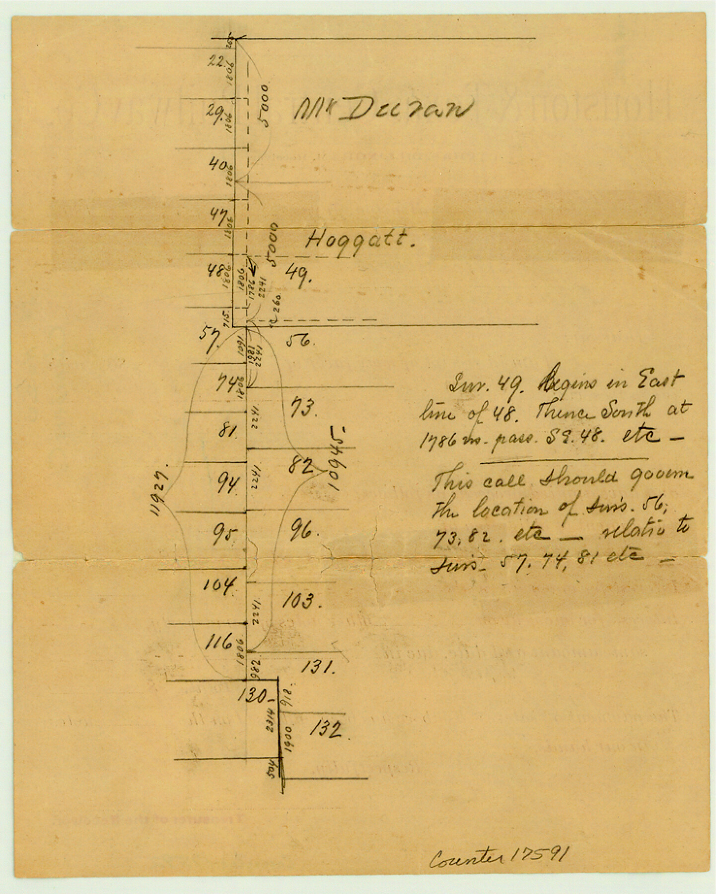
[Sketch of Duran and Hoggatt surveys and area to the south in the east part of the county]
-
Map/Doc
17591
-
Collection
General Map Collection
-
Counties
Chambers
-
Subjects
Surveying Sketch File
-
Height x Width
9.2 x 7.4 inches
23.4 x 18.8 cm
-
Medium
paper, manuscript
Part of: General Map Collection

Galveston Bay, Texas

Print $20.00
- Digital $50.00
Galveston Bay, Texas
1905
Size 24.8 x 18.5 inches
Map/Doc 65390
Freestone County Working Sketch 19

Print $20.00
- Digital $50.00
Freestone County Working Sketch 19
1980
Size 39.3 x 44.4 inches
Map/Doc 69261
Archer County Working Sketch 17

Print $3.00
- Digital $50.00
Archer County Working Sketch 17
1951
Size 10.7 x 12.2 inches
Map/Doc 67158
Lynn County Sketch File 12

Print $4.00
- Digital $50.00
Lynn County Sketch File 12
1907
Size 7.5 x 8.7 inches
Map/Doc 30480

Hays County Working Sketch 13

Print $20.00
- Digital $50.00
Hays County Working Sketch 13
1952
Size 24.2 x 35.0 inches
Map/Doc 66087
Knox County Working Sketch 5

Print $20.00
- Digital $50.00
Knox County Working Sketch 5
1919
Size 27.1 x 23.2 inches
Map/Doc 70247
Taylor County Working Sketch 12

Print $20.00
- Digital $50.00
Taylor County Working Sketch 12
1956
Size 25.5 x 26.9 inches
Map/Doc 69622
Travis County Appraisal District Plat Map 2_0805

Print $20.00
- Digital $50.00
Travis County Appraisal District Plat Map 2_0805
Size 21.4 x 26.4 inches
Map/Doc 94231
Webb County Rolled Sketch 74

Print $20.00
- Digital $50.00
Webb County Rolled Sketch 74
1982
Size 40.7 x 31.9 inches
Map/Doc 10131
Montgomery County Sketch File 12

Print $2.00
- Digital $50.00
Montgomery County Sketch File 12
Size 8.1 x 3.8 inches
Map/Doc 31802
You may also like
Ward County Working Sketch 8

Print $20.00
- Digital $50.00
Ward County Working Sketch 8
1946
Size 22.7 x 33.7 inches
Map/Doc 72314
Flight Mission No. DQN-2K, Frame 89, Calhoun County

Print $20.00
- Digital $50.00
Flight Mission No. DQN-2K, Frame 89, Calhoun County
1953
Size 16.2 x 15.7 inches
Map/Doc 84279
Newton County Sketch File 40

Print $6.00
- Digital $50.00
Newton County Sketch File 40
Size 16.2 x 10.6 inches
Map/Doc 32419
Port Facilities at Houston, Tex.

Print $20.00
- Digital $50.00
Port Facilities at Houston, Tex.
Size 14.1 x 30.3 inches
Map/Doc 97167
Wilbarger Co.

Print $40.00
- Digital $50.00
Wilbarger Co.
1889
Size 48.8 x 38.4 inches
Map/Doc 63125
Nueces County Sketch File 12b

Print $8.00
- Digital $50.00
Nueces County Sketch File 12b
1889
Size 14.2 x 8.8 inches
Map/Doc 32530
Hudspeth county Sketch File 12a

Print $20.00
- Digital $50.00
Hudspeth county Sketch File 12a
1894
Size 13.3 x 34.7 inches
Map/Doc 11800
Reagan County Working Sketch 46b

Print $20.00
- Digital $50.00
Reagan County Working Sketch 46b
1987
Size 31.4 x 45.2 inches
Map/Doc 71889
The Republic County of Lamar. January 28, 1841

Print $20.00
The Republic County of Lamar. January 28, 1841
2020
Size 16.4 x 21.7 inches
Map/Doc 96203
Galveston County Rolled Sketch 21

Print $41.00
- Digital $50.00
Galveston County Rolled Sketch 21
Size 10.5 x 15.1 inches
Map/Doc 45061
Rusk County Working Sketch 3

Print $2.00
- Digital $50.00
Rusk County Working Sketch 3
Size 6.3 x 12.2 inches
Map/Doc 63638
[Surveys along Bosque and Hog Creek]
![238, [Surveys along Bosque and Hog Creek], General Map Collection](https://historictexasmaps.com/wmedia_w700/maps/238.tif.jpg)
Print $20.00
- Digital $50.00
[Surveys along Bosque and Hog Creek]
1845
Size 23.9 x 17.0 inches
Map/Doc 238