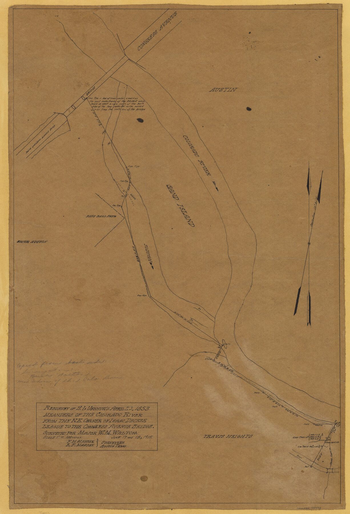
Resurvey of H.L. Upshur's April 23, 1853 meanders of the Colorado River from the NE corner of Isaac Decker league to the Congress Avenue Bridge
-
Map/Doc
75773
-
Collection
Maddox Collection
-
Object Dates
1915 (Creation Date)
-
People and Organizations
E.F. Maddox (Surveyor/Engineer)
F.M. Maddox (Surveyor/Engineer)
-
Counties
Travis
-
Height x Width
24.0 x 16.3 inches
61.0 x 41.4 cm
-
Medium
paper, manuscript
-
Scale
1" = 100 varas
-
Comments
Surveyed June 17 and 18, 1915.
-
Features
Stone's Creek
Colorado River
Sand Island
Travis Heights
Congress Avenue Bridge
Congress Avenue
South Congress Avenue Dyke
Part of: Maddox Collection
Map of Tyler County, Texas

Print $20.00
- Digital $50.00
Map of Tyler County, Texas
1879
Size 28.6 x 22.8 inches
Map/Doc 720
Sketch of Crosby Co.

Print $20.00
- Digital $50.00
Sketch of Crosby Co.
1884
Size 14.8 x 12.5 inches
Map/Doc 506
Map showing Center Lines on Holley St.

Print $3.00
- Digital $50.00
Map showing Center Lines on Holley St.
1912
Size 6.1 x 17.5 inches
Map/Doc 495
Map of Grimes County, Texas

Print $20.00
- Digital $50.00
Map of Grimes County, Texas
1880
Size 29.5 x 15.6 inches
Map/Doc 432
[Pitchfork Ranch]
![4480, [Pitchfork Ranch], Maddox Collection](https://historictexasmaps.com/wmedia_w700/maps/4480.tif.jpg)
Print $20.00
- Digital $50.00
[Pitchfork Ranch]
1915
Size 20.8 x 17.2 inches
Map/Doc 4480
Map of Brazoria Co.

Print $20.00
- Digital $50.00
Map of Brazoria Co.
1879
Size 26.5 x 26.2 inches
Map/Doc 544
Map of Hardin County, Texas

Print $20.00
- Digital $50.00
Map of Hardin County, Texas
1895
Size 22.1 x 20.9 inches
Map/Doc 499
Plat of surveys in El Paso Co. made for Maddox Bro's & Anderson and Gunter & Munson

Print $20.00
- Digital $50.00
Plat of surveys in El Paso Co. made for Maddox Bro's & Anderson and Gunter & Munson
Size 22.2 x 23.4 inches
Map/Doc 713
[Sketch showing voting precincts in Jim Hogg and Brooks Counties]
![4497, [Sketch showing voting precincts in Jim Hogg and Brooks Counties], Maddox Collection](https://historictexasmaps.com/wmedia_w700/maps/4497-1.tif.jpg)
Print $20.00
- Digital $50.00
[Sketch showing voting precincts in Jim Hogg and Brooks Counties]
Size 10.1 x 18.2 inches
Map/Doc 4497
Collingsworth County, Texas

Print $20.00
- Digital $50.00
Collingsworth County, Texas
Size 18.3 x 16.6 inches
Map/Doc 465
Map of surveys 189 & 190, T. C. R.R. Co. in Travis County, Texas

Print $20.00
- Digital $50.00
Map of surveys 189 & 190, T. C. R.R. Co. in Travis County, Texas
1915
Size 18.5 x 25.0 inches
Map/Doc 75761
Map of Tyler County, Texas

Print $20.00
- Digital $50.00
Map of Tyler County, Texas
1882
Size 28.3 x 21.4 inches
Map/Doc 669
You may also like
Runnels County Sketch File 25

Print $20.00
Runnels County Sketch File 25
1940
Size 16.5 x 16.7 inches
Map/Doc 12259
Map showing lands of D. Sullivan known as Santa Rosa Ranch situated in Cameron and Hidalgo Counties, Texas

Print $20.00
- Digital $50.00
Map showing lands of D. Sullivan known as Santa Rosa Ranch situated in Cameron and Hidalgo Counties, Texas
1905
Size 26.2 x 23.2 inches
Map/Doc 4455
Crane County Rolled Sketch 21

Print $20.00
- Digital $50.00
Crane County Rolled Sketch 21
1988
Size 42.5 x 36.6 inches
Map/Doc 8685
Comanche County Working Sketch 16

Print $20.00
- Digital $50.00
Comanche County Working Sketch 16
1969
Size 16.5 x 23.8 inches
Map/Doc 68150
Map of Gray County

Print $20.00
- Digital $50.00
Map of Gray County
1900
Size 43.4 x 40.5 inches
Map/Doc 95511
Harris County Working Sketch 71

Print $20.00
- Digital $50.00
Harris County Working Sketch 71
1957
Size 26.8 x 42.3 inches
Map/Doc 65963
Hudspeth County Rolled Sketch 50

Print $40.00
- Digital $50.00
Hudspeth County Rolled Sketch 50
1971
Size 56.6 x 34.8 inches
Map/Doc 9220

Gregg County Sketch File 1C

Print $6.00
- Digital $50.00
Gregg County Sketch File 1C
1847
Size 7.8 x 11.6 inches
Map/Doc 24540
A Geological Map of the United States and Canada

Print $20.00
A Geological Map of the United States and Canada
1853
Size 17.4 x 25.0 inches
Map/Doc 95189
Brazoria County NRC Article 33.136 Sketch 26

Print $24.00
Brazoria County NRC Article 33.136 Sketch 26
2025
Map/Doc 97471
Map of Baylor County Young Land District, formely Fannin District

Print $20.00
- Digital $50.00
Map of Baylor County Young Land District, formely Fannin District
1859
Size 25.8 x 20.0 inches
Map/Doc 3281