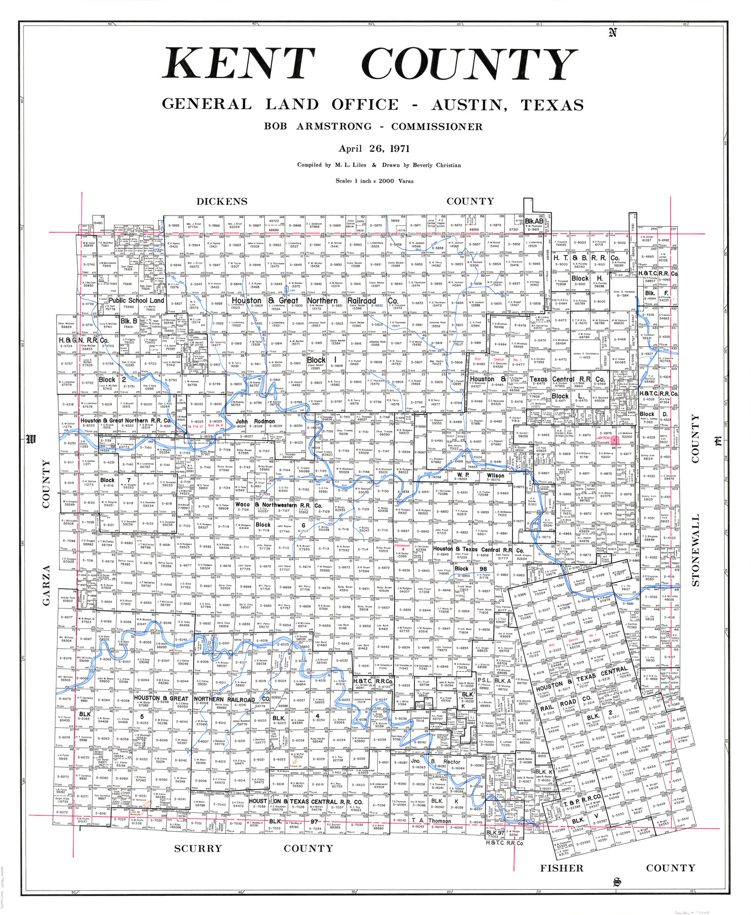
Kent County
-
Map/Doc
73205
-
Collection
General Map Collection
-
Object Dates
1971/4/26 (Creation Date)
-
People and Organizations
Texas General Land Office (Publisher)
Beverly Christian (Draftsman)
Bob Armstrong (GLO Commissioner)
M. L. Liles (Compiler)
-
Counties
Kent
-
Subjects
County
-
Height x Width
44.6 x 37.0 inches
113.3 x 94.0 cm
-
Comments
Leroy lettered.
-
Features
Four Mile Creek
Dry Duck Creek
West Duck Creek
Little Mount McKenzie
Mount McKenzie
Cooper Mountain
Cooper Creek
Double Mountain Fork of Brazos River
McKenzie Creek
Red Mud Creek
Clairemont
Salt Fork of Brazos River
Jayton
White River
Little Red Mud Creek
Cottwood [sic] Creek
Croton River
Duck Creek
Part of: General Map Collection
Armstrong County

Print $20.00
- Digital $50.00
Armstrong County
1879
Size 21.6 x 19.2 inches
Map/Doc 3242
Castro County Rolled Sketch 12

Print $20.00
- Digital $50.00
Castro County Rolled Sketch 12
1945
Size 25.7 x 15.8 inches
Map/Doc 5421
Reagan County Sketch File 29

Print $20.00
- Digital $50.00
Reagan County Sketch File 29
1951
Size 21.3 x 30.5 inches
Map/Doc 12225
Right of Way & Track Map, San Antonio & Aransas Pass Railway Co.

Print $40.00
- Digital $50.00
Right of Way & Track Map, San Antonio & Aransas Pass Railway Co.
1919
Size 25.0 x 56.7 inches
Map/Doc 64215
Val Verde County Working Sketch Graphic Index, Sheet 3 (Sketches 89 to Most Recent)

Print $20.00
- Digital $50.00
Val Verde County Working Sketch Graphic Index, Sheet 3 (Sketches 89 to Most Recent)
1944
Size 40.3 x 36.6 inches
Map/Doc 76726
Mason County Boundary File 4

Print $38.00
- Digital $50.00
Mason County Boundary File 4
Size 8.7 x 4.0 inches
Map/Doc 56852
Dallas County Working Sketch 14

Print $20.00
- Digital $50.00
Dallas County Working Sketch 14
1987
Size 31.2 x 21.7 inches
Map/Doc 68580
Guadalupe County Sketch File 24

Print $4.00
- Digital $50.00
Guadalupe County Sketch File 24
1838
Size 12.9 x 8.4 inches
Map/Doc 24715
Cottle County Sketch File 16

Print $8.00
- Digital $50.00
Cottle County Sketch File 16
1911
Size 10.7 x 8.7 inches
Map/Doc 19518
Wilson County Sketch File 3b

Print $22.00
- Digital $50.00
Wilson County Sketch File 3b
Size 7.8 x 11.9 inches
Map/Doc 40402
Kenedy County Aerial Photograph Index Sheet 5

Print $20.00
- Digital $50.00
Kenedy County Aerial Photograph Index Sheet 5
1943
Size 23.5 x 19.6 inches
Map/Doc 89046
Jackson County Working Sketch 10

Print $20.00
- Digital $50.00
Jackson County Working Sketch 10
1991
Size 35.9 x 36.1 inches
Map/Doc 66458
You may also like
Galveston County NRC Article 33.136 Sketch 93

Digital $50.00
Galveston County NRC Article 33.136 Sketch 93
2020
Map/Doc 97257
Mills County Sketch File A

Print $4.00
- Digital $50.00
Mills County Sketch File A
1890
Size 8.9 x 11.0 inches
Map/Doc 31646
Flight Mission No. CRE-1R, Frame 122, Jackson County

Print $20.00
- Digital $50.00
Flight Mission No. CRE-1R, Frame 122, Jackson County
1956
Size 16.2 x 16.0 inches
Map/Doc 85333
Menard County Sketch File 26

Print $8.00
- Digital $50.00
Menard County Sketch File 26
1936
Size 8.7 x 14.3 inches
Map/Doc 31560
Kerr County Working Sketch 22

Print $40.00
- Digital $50.00
Kerr County Working Sketch 22
1965
Size 50.9 x 40.4 inches
Map/Doc 70053
Kimble County Working Sketch 36

Print $40.00
- Digital $50.00
Kimble County Working Sketch 36
1946
Size 53.6 x 43.1 inches
Map/Doc 70104
Chambers County NRC Article 33.136 Sketch 8

Print $22.00
- Digital $50.00
Chambers County NRC Article 33.136 Sketch 8
2014
Size 17.7 x 24.0 inches
Map/Doc 94745
Val Verde County Sketch File A3

Print $20.00
- Digital $50.00
Val Verde County Sketch File A3
1917
Size 25.6 x 42.3 inches
Map/Doc 10418
Map of Cherokee County

Print $40.00
- Digital $50.00
Map of Cherokee County
1933
Size 59.9 x 41.5 inches
Map/Doc 1799
Culberson County Rolled Sketch 29

Print $20.00
- Digital $50.00
Culberson County Rolled Sketch 29
Size 44.3 x 21.4 inches
Map/Doc 8745
General Highway Map, Ector County, Texas

Print $20.00
General Highway Map, Ector County, Texas
1940
Size 18.4 x 24.9 inches
Map/Doc 79081
Houston Ship Channel, Alexander Island to Carpenter Bayou

Print $20.00
- Digital $50.00
Houston Ship Channel, Alexander Island to Carpenter Bayou
1975
Size 36.0 x 47.0 inches
Map/Doc 69912