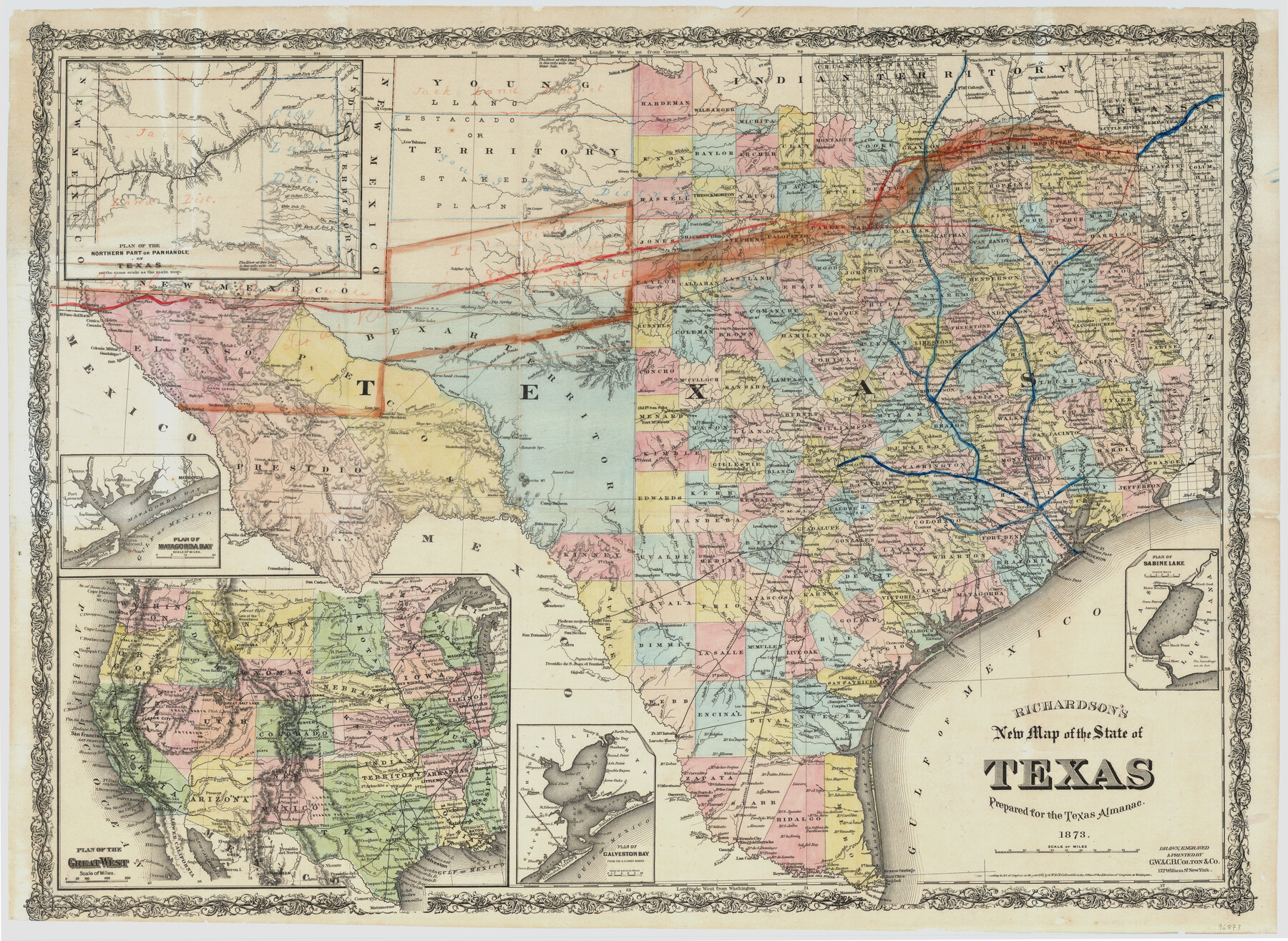
Richardson's New Map of the State of Texas prepared for the Texas Almanac
-
Map/Doc
96873
-
Collection
General Map Collection
-
Object Dates
1873 (Creation Date)
-
People and Organizations
G.W. & C.B. Colton & Co. (Printer)
-
Subjects
State of Texas
-
Height x Width
19.8 x 27.1 inches
50.3 x 68.8 cm
-
Medium
paper, etching/engraving/lithograph
Part of: General Map Collection
Dallas County Sketch File 10

Print $4.00
- Digital $50.00
Dallas County Sketch File 10
1858
Size 12.5 x 8.2 inches
Map/Doc 20414
Crockett County Working Sketch 40

Print $20.00
- Digital $50.00
Crockett County Working Sketch 40
1928
Size 29.5 x 23.7 inches
Map/Doc 68373
Dallas County Sketch File 14

Print $22.00
- Digital $50.00
Dallas County Sketch File 14
1859
Size 8.2 x 7.6 inches
Map/Doc 20428
Upton County Rolled Sketch 56

Print $158.00
- Digital $50.00
Upton County Rolled Sketch 56
1934
Size 10.0 x 15.1 inches
Map/Doc 49413
Brewster County Rolled Sketch 22C

Print $20.00
- Digital $50.00
Brewster County Rolled Sketch 22C
1910
Size 23.7 x 18.8 inches
Map/Doc 5204
Water-Shed of the Brazos River

Print $40.00
- Digital $50.00
Water-Shed of the Brazos River
1925
Size 35.0 x 88.0 inches
Map/Doc 65263
Denton County Boundary File 3

Print $34.00
- Digital $50.00
Denton County Boundary File 3
Size 6.1 x 3.9 inches
Map/Doc 52424
Flight Mission No. DAG-23K, Frame 18, Matagorda County

Print $20.00
- Digital $50.00
Flight Mission No. DAG-23K, Frame 18, Matagorda County
1953
Size 18.5 x 22.2 inches
Map/Doc 86480
Willacy County Aerial Photograph Index Sheet 2

Print $20.00
- Digital $50.00
Willacy County Aerial Photograph Index Sheet 2
1940
Size 24.3 x 20.2 inches
Map/Doc 83757
Menard County Sketch File 26

Print $8.00
- Digital $50.00
Menard County Sketch File 26
1936
Size 8.7 x 14.3 inches
Map/Doc 31560
City of Aransas Pass and Chart of Aransas Bay and Corpus Christi Bay, Texas

Print $20.00
- Digital $50.00
City of Aransas Pass and Chart of Aransas Bay and Corpus Christi Bay, Texas
1905
Size 28.4 x 21.4 inches
Map/Doc 97265
Post Route Map of the State of Texas, Showing Post Offices with the Intermediate Distances on Mail Routes

Print $40.00
- Digital $50.00
Post Route Map of the State of Texas, Showing Post Offices with the Intermediate Distances on Mail Routes
1908
Size 52.5 x 35.1 inches
Map/Doc 3163
You may also like
Rio Grande, Fernando Sheet

Print $4.00
- Digital $50.00
Rio Grande, Fernando Sheet
1935
Size 20.8 x 25.8 inches
Map/Doc 65114
[Public School Land Blocks]
![93151, [Public School Land Blocks], Twichell Survey Records](https://historictexasmaps.com/wmedia_w700/maps/93151-1.tif.jpg)
Print $40.00
- Digital $50.00
[Public School Land Blocks]
Size 45.0 x 114.7 inches
Map/Doc 93151
Brazoria County Sketch File 31

Print $40.00
- Digital $50.00
Brazoria County Sketch File 31
1894
Size 17.4 x 14.4 inches
Map/Doc 15039
Austin County Boundary File 4

Print $10.00
- Digital $50.00
Austin County Boundary File 4
Size 14.1 x 8.6 inches
Map/Doc 50244
Panola County, Texas

Print $20.00
- Digital $50.00
Panola County, Texas
1879
Size 18.0 x 19.4 inches
Map/Doc 654
Controlled Mosaic by Jack Amman Photogrammetric Engineers, Inc - Sheet 18

Print $20.00
- Digital $50.00
Controlled Mosaic by Jack Amman Photogrammetric Engineers, Inc - Sheet 18
1954
Size 19.4 x 24.0 inches
Map/Doc 83463
Section 54 Block Y

Print $20.00
- Digital $50.00
Section 54 Block Y
Size 23.9 x 19.4 inches
Map/Doc 92462
Webb County Boundary File 8

Print $113.00
- Digital $50.00
Webb County Boundary File 8
Size 14.3 x 8.8 inches
Map/Doc 59822
Outer Continental Shelf Leasing Maps (Texas Offshore Operations)

Print $20.00
- Digital $50.00
Outer Continental Shelf Leasing Maps (Texas Offshore Operations)
Size 29.9 x 21.7 inches
Map/Doc 75857
Concho County Sketch File 38

Print $4.00
- Digital $50.00
Concho County Sketch File 38
1938
Size 14.6 x 9.0 inches
Map/Doc 19188
[Aerial photograph from Carancahua Bend of Caney Creek to Cedar Lake]
![78639, [Aerial photograph from Carancahua Bend of Caney Creek to Cedar Lake], General Map Collection](https://historictexasmaps.com/wmedia_w700/maps/78639.tif.jpg)
Print $20.00
- Digital $50.00
[Aerial photograph from Carancahua Bend of Caney Creek to Cedar Lake]
1991
Size 24.4 x 34.0 inches
Map/Doc 78639
[Surveys along the Cibolo, Balcones and Leon Creeks]
![69728, [Surveys along the Cibolo, Balcones and Leon Creeks], General Map Collection](https://historictexasmaps.com/wmedia_w700/maps/69728-1.tif.jpg)
Print $20.00
- Digital $50.00
[Surveys along the Cibolo, Balcones and Leon Creeks]
1841
Size 14.5 x 21.0 inches
Map/Doc 69728