Archer County Rolled Sketch 9
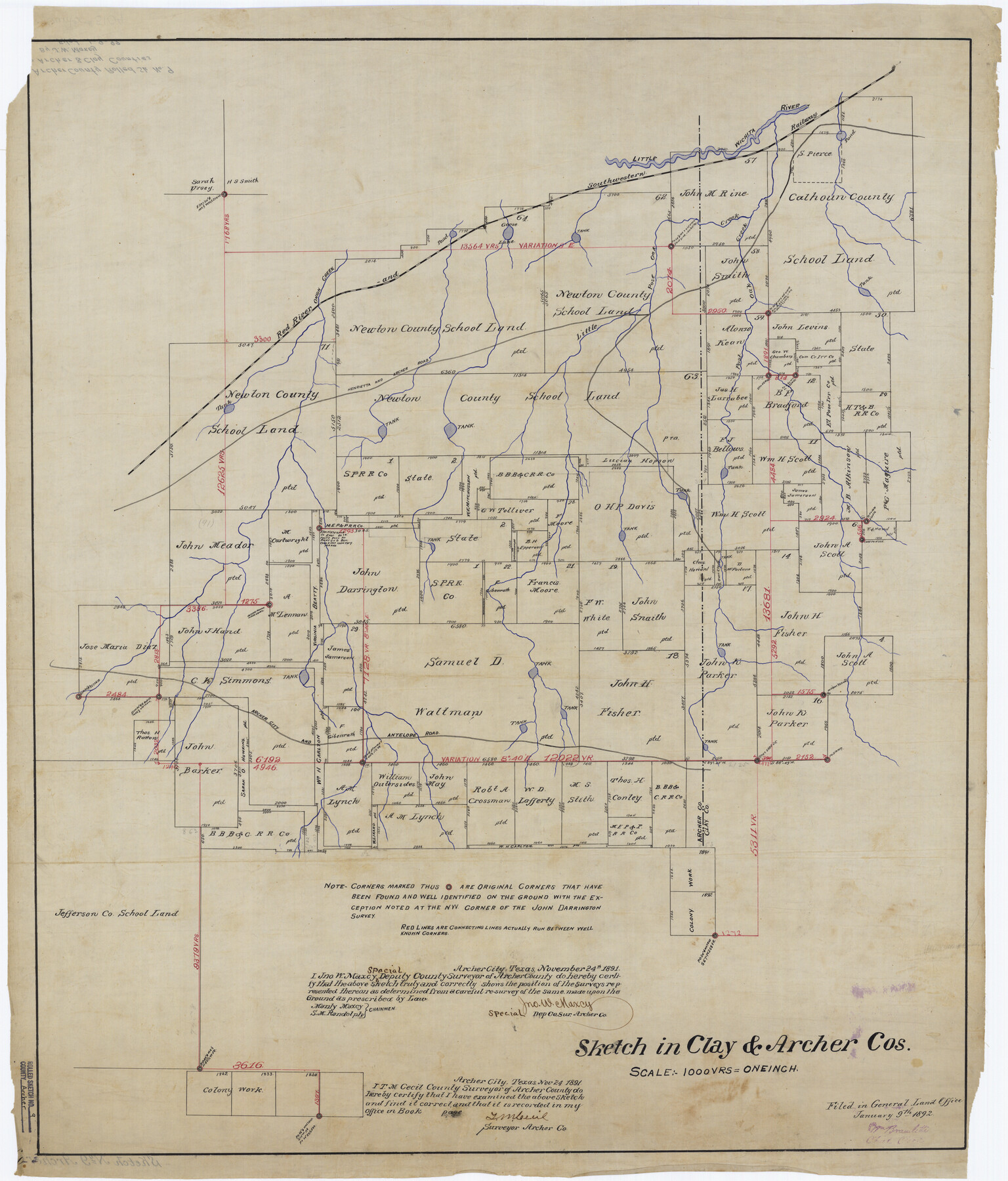
Sketch in Clay & Archer Cos. [in east part of Archer County along Archer-Clay county line, south of Little Wichita River]
-
Map/Doc
5104
-
Collection
General Map Collection
-
Object Dates
1891/11/24 (Creation Date)
1892/1/9 (File Date)
-
People and Organizations
John W. Maxcy (Surveyor/Engineer)
Manly Maxcy (Chainman/Field Personnel)
S.M. Randolph (Chainman/Field Personnel)
T.M. Cecil (Surveyor/Engineer)
-
Counties
Archer Clay
-
Subjects
Surveying Rolled Sketch
-
Height x Width
35.9 x 30.6 inches
91.2 x 77.7 cm
-
Medium
linen, manuscript
-
Scale
1" = 1000 varas
Part of: General Map Collection
Wichita County Sketch File D

Print $22.00
- Digital $50.00
Wichita County Sketch File D
1919
Size 12.0 x 8.6 inches
Map/Doc 40061
La Salle County Working Sketch 3

Print $20.00
- Digital $50.00
La Salle County Working Sketch 3
1914
Size 15.0 x 14.2 inches
Map/Doc 70304
Map of Brazoria

Print $20.00
- Digital $50.00
Map of Brazoria
1860
Size 19.8 x 26.7 inches
Map/Doc 856
Brewster County Sketch File 56

Print $14.00
- Digital $50.00
Brewster County Sketch File 56
2001
Size 11.0 x 8.5 inches
Map/Doc 16392
Kinney County Sketch File 18

Print $20.00
- Digital $50.00
Kinney County Sketch File 18
Size 29.0 x 25.2 inches
Map/Doc 11943
Baylor County Sketch File 9

Print $50.00
- Digital $50.00
Baylor County Sketch File 9
1890
Size 13.4 x 9.0 inches
Map/Doc 14139
Victoria County Rolled Sketch 6

Print $20.00
- Digital $50.00
Victoria County Rolled Sketch 6
Size 27.9 x 36.3 inches
Map/Doc 8152
Wharton County Working Sketch 13

Print $20.00
- Digital $50.00
Wharton County Working Sketch 13
1968
Size 38.5 x 36.3 inches
Map/Doc 72477
Fort Bend County Sketch File 31

Print $10.00
- Digital $50.00
Fort Bend County Sketch File 31
1940
Size 13.3 x 8.7 inches
Map/Doc 22997
Floyd County Sketch File 6

Print $2.00
- Digital $50.00
Floyd County Sketch File 6
Size 9.1 x 14.4 inches
Map/Doc 22696
Brazoria County Working Sketch 36

Print $40.00
- Digital $50.00
Brazoria County Working Sketch 36
1981
Size 43.4 x 71.4 inches
Map/Doc 67521
Fort Bend County Sketch File 1

Print $6.00
- Digital $50.00
Fort Bend County Sketch File 1
Size 14.7 x 9.5 inches
Map/Doc 22876
You may also like
Sketch of surveys in Houston Co. on Pine Bayou

Print $2.00
- Digital $50.00
Sketch of surveys in Houston Co. on Pine Bayou
Size 7.7 x 7.6 inches
Map/Doc 69742
Coleman County Sketch File 26

Print $40.00
- Digital $50.00
Coleman County Sketch File 26
1873
Size 12.7 x 15.5 inches
Map/Doc 18712
Bandera County Working Sketch 36

Print $20.00
- Digital $50.00
Bandera County Working Sketch 36
1966
Size 22.5 x 29.5 inches
Map/Doc 67632
Moore County Rolled Sketch 7

Print $20.00
- Digital $50.00
Moore County Rolled Sketch 7
1911
Size 36.0 x 29.3 inches
Map/Doc 6826
Edwards County Sketch File 35a

Print $20.00
- Digital $50.00
Edwards County Sketch File 35a
1928
Size 33.0 x 23.5 inches
Map/Doc 11435
Bexar County Working Sketch 23

Print $20.00
- Digital $50.00
Bexar County Working Sketch 23
1987
Size 27.7 x 34.3 inches
Map/Doc 67339
The Texas and Pacific Ry. Co., Station Map, Iatan, Mitchell County, Texas

Print $20.00
- Digital $50.00
The Texas and Pacific Ry. Co., Station Map, Iatan, Mitchell County, Texas
1929
Size 11.0 x 18.4 inches
Map/Doc 64667
[Surveys near Seco Creek]
![225, [Surveys near Seco Creek], General Map Collection](https://historictexasmaps.com/wmedia_w700/maps/225.tif.jpg)
Print $2.00
- Digital $50.00
[Surveys near Seco Creek]
1846
Size 13.1 x 7.3 inches
Map/Doc 225
[Val Verde County]
![63096, [Val Verde County], General Map Collection](https://historictexasmaps.com/wmedia_w700/maps/63096.tif.jpg)
Print $20.00
- Digital $50.00
[Val Verde County]
1898
Size 42.6 x 34.9 inches
Map/Doc 63096
Atascosa County Rolled Sketch 5B1

Print $20.00
- Digital $50.00
Atascosa County Rolled Sketch 5B1
Size 14.6 x 11.7 inches
Map/Doc 5090
de Leon Empresario Colony. Absorbed by DeWitt Colony. April 15, 1825

Print $20.00
de Leon Empresario Colony. Absorbed by DeWitt Colony. April 15, 1825
2020
Size 18.5 x 21.7 inches
Map/Doc 95989
Zavala County Working Sketch 25

Print $20.00
- Digital $50.00
Zavala County Working Sketch 25
1984
Size 37.7 x 30.0 inches
Map/Doc 62100