Jim Hogg County Sketch File 4
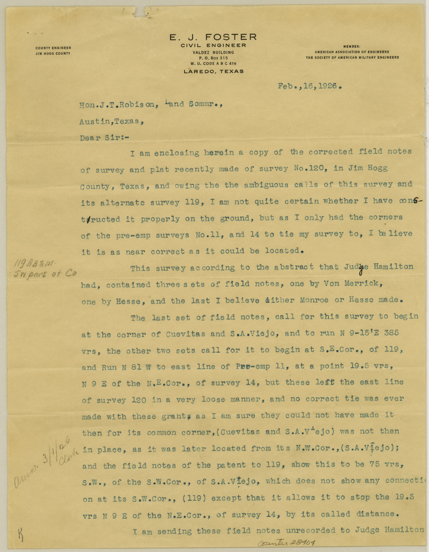
[Letter in regard to corrected field notes of no. 120, A. B. & M. in southwest part of county]
-
Map/Doc
28404
-
Collection
General Map Collection
-
Object Dates
2/16/1926 (Creation Date)
2/16/1926 (Correspondence Date)
-
People and Organizations
E.J. Foster (Surveyor/Engineer)
Martin Van Merrick (Surveyor/Engineer)
Hesse (Surveyor/Engineer)
-
Counties
Jim Hogg
-
Subjects
Surveying Sketch File
-
Height x Width
11.2 x 8.7 inches
28.5 x 22.1 cm
-
Medium
paper, print
Part of: General Map Collection
Flight Mission No. CRK-8P, Frame 98, Refugio County

Print $20.00
- Digital $50.00
Flight Mission No. CRK-8P, Frame 98, Refugio County
1956
Size 18.2 x 22.0 inches
Map/Doc 86959
Runnels County Rolled Sketch 33

Print $20.00
- Digital $50.00
Runnels County Rolled Sketch 33
Size 22.5 x 43.5 inches
Map/Doc 7520
America Settentrionale colle nuove scoperte fin all’anno 1688

Print $20.00
- Digital $50.00
America Settentrionale colle nuove scoperte fin all’anno 1688
1688
Size 29.7 x 37.5 inches
Map/Doc 93709
[Surveys along Eight Mile Creek, Harrison District]
![278, [Surveys along Eight Mile Creek, Harrison District], General Map Collection](https://historictexasmaps.com/wmedia_w700/maps/278.tif.jpg)
Print $3.00
- Digital $50.00
[Surveys along Eight Mile Creek, Harrison District]
Size 12.6 x 9.3 inches
Map/Doc 278
Map of Liberty County Texas

Print $20.00
- Digital $50.00
Map of Liberty County Texas
1895
Size 25.1 x 26.6 inches
Map/Doc 3812
Baylor County Working Sketch 4

Print $20.00
- Digital $50.00
Baylor County Working Sketch 4
1938
Size 30.4 x 21.0 inches
Map/Doc 67289
Swisher County Rolled Sketch 3

Print $20.00
- Digital $50.00
Swisher County Rolled Sketch 3
Size 21.3 x 19.4 inches
Map/Doc 7904


Map of Falls County

Print $20.00
- Digital $50.00
Map of Falls County
1874
Size 20.3 x 21.5 inches
Map/Doc 3528
Brewster County Rolled Sketch 18B

Print $20.00
- Digital $50.00
Brewster County Rolled Sketch 18B
1906
Size 16.2 x 18.1 inches
Map/Doc 5197
[Surveys along Buffalo Bayou]
![153, [Surveys along Buffalo Bayou], General Map Collection](https://historictexasmaps.com/wmedia_w700/maps/153.tif.jpg)
Print $2.00
- Digital $50.00
[Surveys along Buffalo Bayou]
Size 6.3 x 3.9 inches
Map/Doc 153
You may also like
Blucher's Directory Map of Corpus Christi and Road Map of Nueces County

Print $20.00
- Digital $50.00
Blucher's Directory Map of Corpus Christi and Road Map of Nueces County
1945
Size 22.6 x 34.3 inches
Map/Doc 94106
Jim Hogg County Rolled Sketch 3

Print $20.00
- Digital $50.00
Jim Hogg County Rolled Sketch 3
1912
Size 28.2 x 20.2 inches
Map/Doc 6439
Montgomery County Rolled Sketch 19A

Print $40.00
- Digital $50.00
Montgomery County Rolled Sketch 19A
1933
Size 53.4 x 35.4 inches
Map/Doc 9530
Flight Mission No. CRC-4R, Frame 64, Chambers County

Print $20.00
- Digital $50.00
Flight Mission No. CRC-4R, Frame 64, Chambers County
1956
Size 18.7 x 22.3 inches
Map/Doc 84868
La Salle County Working Sketch 35

Print $20.00
- Digital $50.00
La Salle County Working Sketch 35
1958
Size 31.4 x 16.8 inches
Map/Doc 70336
Cass County Working Sketch 55

Print $20.00
- Digital $50.00
Cass County Working Sketch 55
2013
Size 17.3 x 20.6 inches
Map/Doc 93415
Nueces County Rolled Sketch 13

Print $20.00
- Digital $50.00
Nueces County Rolled Sketch 13
1930
Size 26.5 x 18.5 inches
Map/Doc 6869
Harris County Rolled Sketch T2

Print $20.00
- Digital $50.00
Harris County Rolled Sketch T2
1916
Size 26.8 x 23.2 inches
Map/Doc 6145
Wharton County Working Sketch 18

Print $20.00
- Digital $50.00
Wharton County Working Sketch 18
1948
Size 19.3 x 17.0 inches
Map/Doc 72482
Pecos County Sketch File 27c

Print $4.00
- Digital $50.00
Pecos County Sketch File 27c
Size 11.1 x 9.1 inches
Map/Doc 33681
Lgs. 276 thru 280-289, 333, 336, 345, 355 thru 357, 367, Blk. K11

Print $20.00
- Digital $50.00
Lgs. 276 thru 280-289, 333, 336, 345, 355 thru 357, 367, Blk. K11
Size 28.0 x 12.3 inches
Map/Doc 91429
A New Map of Texas, Oregon and California with the Regions adjoining

Print $20.00
- Digital $50.00
A New Map of Texas, Oregon and California with the Regions adjoining
1846
Size 20.4 x 19.3 inches
Map/Doc 89067