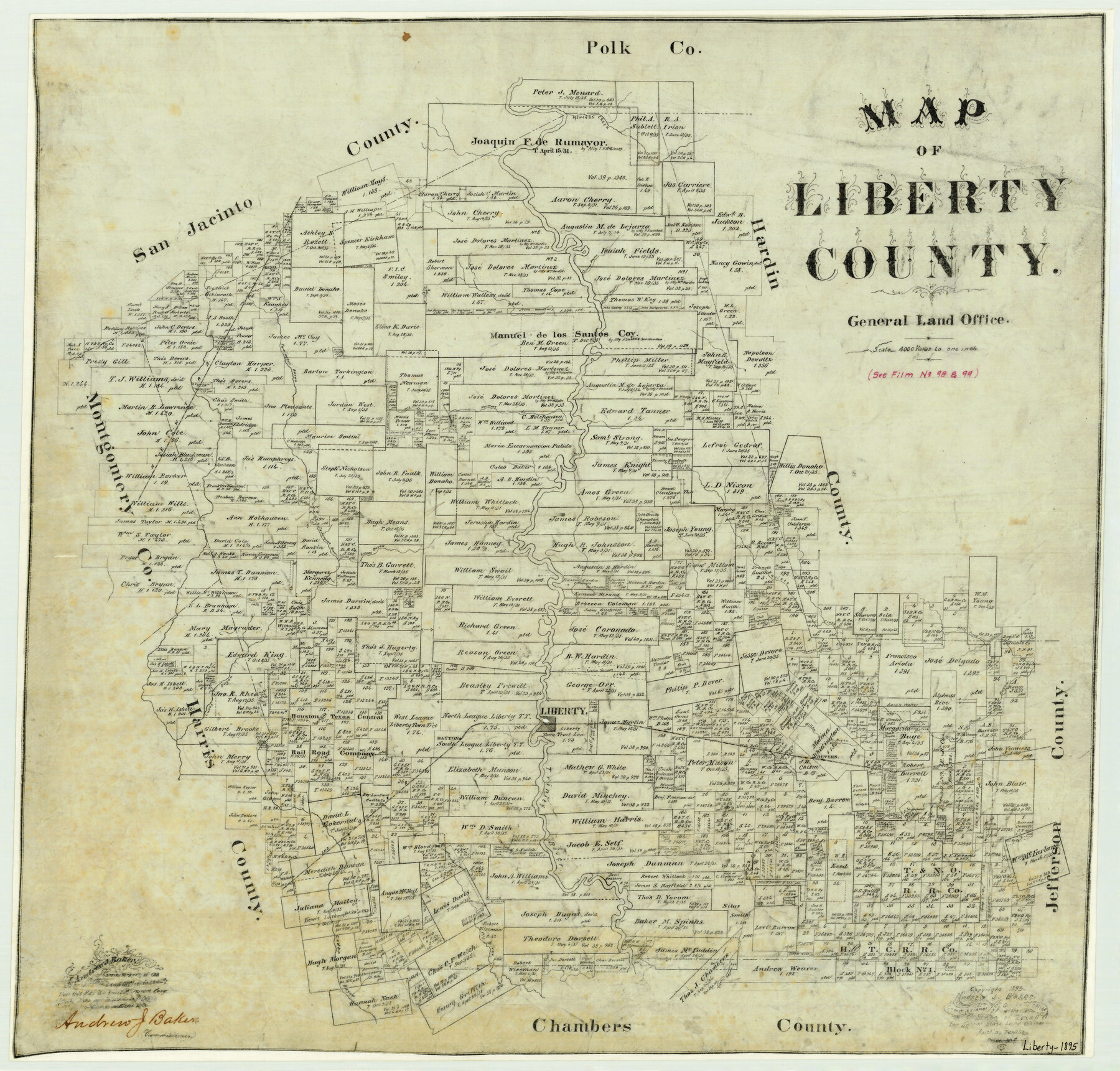
Map of Liberty County Texas
-
Map/Doc
3812
-
Collection
General Map Collection
-
Object Dates
1895 (Creation Date)
-
People and Organizations
A.J. Baker (GLO Commissioner)
-
Counties
Liberty
-
Subjects
County
-
Height x Width
25.1 x 26.6 inches
63.8 x 67.6 cm
-
Comments
Copyrighted 1895.
-
Features
C[]ers Creek
Turtle Bayou
Old River
Cedar Bayou
T&NO
Trinity River
Devers
Willow Marsh Bayou
Willow Bayou
Liberty
Dayton
Menards Creek
Batiste Creek
Cypress Creek
North Prong of Island Bayou
Luces Bayou
HE&WT
Newmans Creek
Tarkington Bayou
Keno
Buffalo Head Creek
Cypress Bayou
Part of: General Map Collection
Comanche County Sketch File 26

Print $20.00
- Digital $50.00
Comanche County Sketch File 26
Size 18.0 x 17.5 inches
Map/Doc 11144
King County Rolled Sketch 13

Print $40.00
- Digital $50.00
King County Rolled Sketch 13
Size 50.5 x 29.3 inches
Map/Doc 9353
Orange County Working Sketch 37

Print $40.00
- Digital $50.00
Orange County Working Sketch 37
1962
Size 37.7 x 54.0 inches
Map/Doc 71369
Montgomery County Rolled Sketch 42

Print $20.00
- Digital $50.00
Montgomery County Rolled Sketch 42
1939
Size 13.9 x 20.1 inches
Map/Doc 6819
Mills County Boundary File 8

Print $10.00
- Digital $50.00
Mills County Boundary File 8
Size 14.2 x 8.7 inches
Map/Doc 57313
San Jacinto County Working Sketch 45

Print $20.00
- Digital $50.00
San Jacinto County Working Sketch 45
1986
Size 41.0 x 46.7 inches
Map/Doc 63759
Tom Green County Rolled Sketch 2

Print $20.00
- Digital $50.00
Tom Green County Rolled Sketch 2
Size 17.2 x 26.8 inches
Map/Doc 7992
Palo Pinto County Working Sketch 26

Print $20.00
- Digital $50.00
Palo Pinto County Working Sketch 26
1993
Map/Doc 71409
Runnels County Rolled Sketch 48

Print $20.00
- Digital $50.00
Runnels County Rolled Sketch 48
Size 32.4 x 36.7 inches
Map/Doc 7533
Jefferson County Working Sketch 42

Print $20.00
- Digital $50.00
Jefferson County Working Sketch 42
1996
Size 31.7 x 47.2 inches
Map/Doc 66586
Flight Mission No. CLL-1N, Frame 112, Willacy County

Print $20.00
- Digital $50.00
Flight Mission No. CLL-1N, Frame 112, Willacy County
1954
Size 18.4 x 20.1 inches
Map/Doc 87046

You may also like
Brown County Rolled Sketch 3

Print $20.00
- Digital $50.00
Brown County Rolled Sketch 3
1985
Size 25.0 x 36.5 inches
Map/Doc 5353
Palo Pinto County Working Sketch 21

Print $20.00
- Digital $50.00
Palo Pinto County Working Sketch 21
1984
Size 37.9 x 39.9 inches
Map/Doc 71404
Hudspeth County Working Sketch 30

Print $40.00
- Digital $50.00
Hudspeth County Working Sketch 30
Size 80.4 x 36.0 inches
Map/Doc 66313
Dickens County, Texas

Print $20.00
- Digital $50.00
Dickens County, Texas
Size 33.7 x 39.8 inches
Map/Doc 92588
Starr County Sketch File 11

Print $28.00
- Digital $50.00
Starr County Sketch File 11
1885
Size 12.8 x 8.1 inches
Map/Doc 36865
Eastland County Working Sketch 17

Print $20.00
- Digital $50.00
Eastland County Working Sketch 17
1919
Size 18.3 x 16.2 inches
Map/Doc 68798
Aerial Perspective of Packery Channel

Print $20.00
- Digital $50.00
Aerial Perspective of Packery Channel
1938
Size 16.5 x 19.3 inches
Map/Doc 3001
General Highway Map, Hill County, Texas

Print $20.00
General Highway Map, Hill County, Texas
1940
Size 25.0 x 18.6 inches
Map/Doc 79129
Controlled Mosaic by Jack Amman Photogrammetric Engineers, Inc - Sheet 44

Print $20.00
- Digital $50.00
Controlled Mosaic by Jack Amman Photogrammetric Engineers, Inc - Sheet 44
1954
Size 20.0 x 24.0 inches
Map/Doc 83503
Lamar County Rolled Sketch 1

Print $40.00
- Digital $50.00
Lamar County Rolled Sketch 1
1989
Size 50.3 x 39.1 inches
Map/Doc 9553
San Jacinto County Working Sketch 7

Print $20.00
- Digital $50.00
San Jacinto County Working Sketch 7
1935
Size 32.0 x 41.4 inches
Map/Doc 63720
[Southeast part of County near Jas. H. Price Survey]
![91888, [Southeast part of County near Jas. H. Price Survey], Twichell Survey Records](https://historictexasmaps.com/wmedia_w700/maps/91888-1.tif.jpg)
Print $20.00
- Digital $50.00
[Southeast part of County near Jas. H. Price Survey]
Size 19.3 x 19.3 inches
Map/Doc 91888