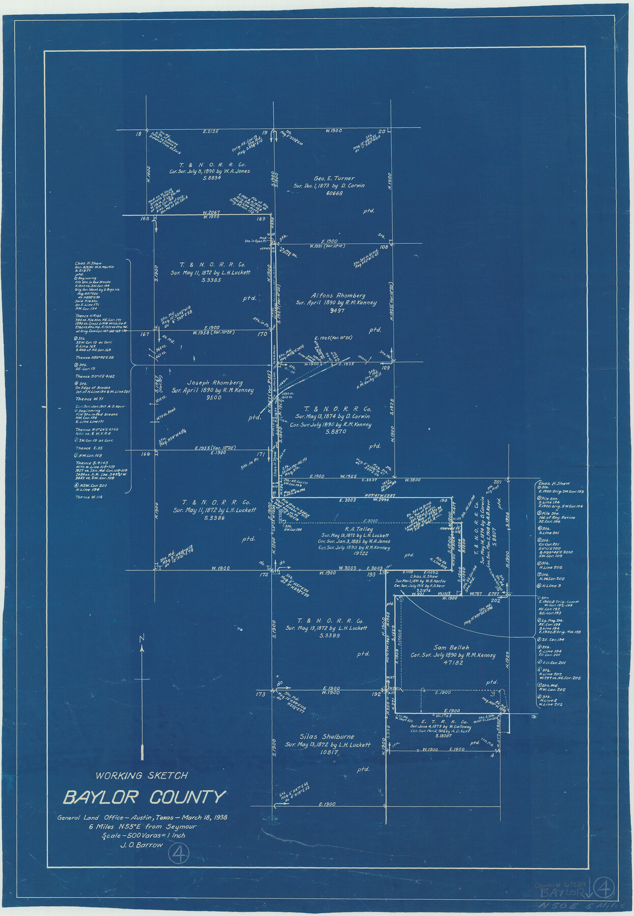
Baylor County Working Sketch 4
-
Map/Doc
67289
-
Collection
General Map Collection
-
Object Dates
3/18/1938 (Creation Date)
-
People and Organizations
J.O. Barrow (Draftsman)
-
Counties
Baylor
-
Subjects
Surveying Working Sketch
-
Height x Width
30.4 x 21.0 inches
77.2 x 53.3 cm
-
Scale
1" = 500 varas
-
Comments
Surveys located about five miles North 50 degrees East of Seymour, Texas.
Part of: General Map Collection
Chambers County Aerial Photograph Index Sheet 2

Print $20.00
- Digital $50.00
Chambers County Aerial Photograph Index Sheet 2
1956
Size 19.4 x 15.7 inches
Map/Doc 83683
Randall County Rolled Sketch 3

Print $20.00
- Digital $50.00
Randall County Rolled Sketch 3
Size 22.0 x 24.9 inches
Map/Doc 7423
Map of the Western Territory &c.

Print $20.00
- Digital $50.00
Map of the Western Territory &c.
1834
Size 18.5 x 18.8 inches
Map/Doc 95691
Outer Continental Shelf Leasing Maps (Texas Offshore Operations)

Print $20.00
- Digital $50.00
Outer Continental Shelf Leasing Maps (Texas Offshore Operations)
1954
Size 20.8 x 15.8 inches
Map/Doc 75838
Matagorda County Sketch File 14

Print $40.00
- Digital $50.00
Matagorda County Sketch File 14
Size 13.5 x 14.8 inches
Map/Doc 30772
Loving County Working Sketch 8

Print $40.00
- Digital $50.00
Loving County Working Sketch 8
1952
Size 21.9 x 56.6 inches
Map/Doc 70640
[Sketch for Mineral Application 24072, San Jacinto River]
![65598, [Sketch for Mineral Application 24072, San Jacinto River], General Map Collection](https://historictexasmaps.com/wmedia_w700/maps/65598.tif.jpg)
Print $20.00
- Digital $50.00
[Sketch for Mineral Application 24072, San Jacinto River]
1929
Size 24.6 x 18.3 inches
Map/Doc 65598
Presidio County Rolled Sketch 75

Print $20.00
- Digital $50.00
Presidio County Rolled Sketch 75
1938
Size 24.8 x 20.0 inches
Map/Doc 7363
Pecos County Rolled Sketch 152

Print $20.00
- Digital $50.00
Pecos County Rolled Sketch 152
1960
Size 38.8 x 43.7 inches
Map/Doc 9736
Denton County Sketch File 25

Print $4.00
- Digital $50.00
Denton County Sketch File 25
1863
Size 8.0 x 7.4 inches
Map/Doc 20752
Ochiltree County Boundary File 5a

Print $10.00
- Digital $50.00
Ochiltree County Boundary File 5a
Size 13.7 x 8.7 inches
Map/Doc 57692
El Paso County Rolled Sketch 23

Print $20.00
- Digital $50.00
El Paso County Rolled Sketch 23
1888
Size 46.2 x 38.1 inches
Map/Doc 8856
You may also like
[Location Survey of the Southern Kansas Railway, Kiowa Extension from a point in Drake's Location, in Indian Territory 100 miles from south line of Kansas, continuing up Wolf Creek and South Canadian River to Cottonwood Creek in Hutchinson County]
![88845, [Location Survey of the Southern Kansas Railway, Kiowa Extension from a point in Drake's Location, in Indian Territory 100 miles from south line of Kansas, continuing up Wolf Creek and South Canadian River to Cottonwood Creek in Hutchinson County], General Map Collection](https://historictexasmaps.com/wmedia_w700/maps/88845.tif.jpg)
Print $20.00
- Digital $50.00
[Location Survey of the Southern Kansas Railway, Kiowa Extension from a point in Drake's Location, in Indian Territory 100 miles from south line of Kansas, continuing up Wolf Creek and South Canadian River to Cottonwood Creek in Hutchinson County]
1886
Size 37.5 x 36.0 inches
Map/Doc 88845
Webb County Working Sketch 23

Print $20.00
- Digital $50.00
Webb County Working Sketch 23
1927
Size 15.1 x 17.3 inches
Map/Doc 72388

Kent County Sketch File A

Print $4.00
- Digital $50.00
Kent County Sketch File A
Size 8.2 x 9.0 inches
Map/Doc 28821
From Citizens of Shelby County for the Creation of a New County to be Called Caddo, April 7, 1838

Print $20.00
From Citizens of Shelby County for the Creation of a New County to be Called Caddo, April 7, 1838
2020
Size 25.5 x 21.7 inches
Map/Doc 96377
Shackelford County Working Sketch 15

Print $20.00
- Digital $50.00
Shackelford County Working Sketch 15
2012
Size 28.4 x 20.7 inches
Map/Doc 93321
Kimble County Working Sketch 24

Print $20.00
- Digital $50.00
Kimble County Working Sketch 24
1930
Size 23.3 x 17.4 inches
Map/Doc 70092
[T. & P. Block 44, Township 2S]
![90949, [T. & P. Block 44, Township 2S], Twichell Survey Records](https://historictexasmaps.com/wmedia_w700/maps/90949-1.tif.jpg)
Print $20.00
- Digital $50.00
[T. & P. Block 44, Township 2S]
Size 10.0 x 21.9 inches
Map/Doc 90949
Trinity County Working Sketch 24

Print $20.00
- Digital $50.00
Trinity County Working Sketch 24
2010
Size 18.2 x 36.5 inches
Map/Doc 89599
Right of Way and Track Map Texas & New Orleans R.R. Co. operated by the T. & N. O. R.R. Co. Dallas-Sabine Branch

Print $40.00
- Digital $50.00
Right of Way and Track Map Texas & New Orleans R.R. Co. operated by the T. & N. O. R.R. Co. Dallas-Sabine Branch
1918
Size 26.4 x 56.7 inches
Map/Doc 64154
Tom Green County Sketch File 41

Print $8.00
- Digital $50.00
Tom Green County Sketch File 41
1884
Size 12.8 x 8.3 inches
Map/Doc 38196
Wilson County Boundary File 5a

Print $20.00
- Digital $50.00
Wilson County Boundary File 5a
Size 12.0 x 28.0 inches
Map/Doc 60118