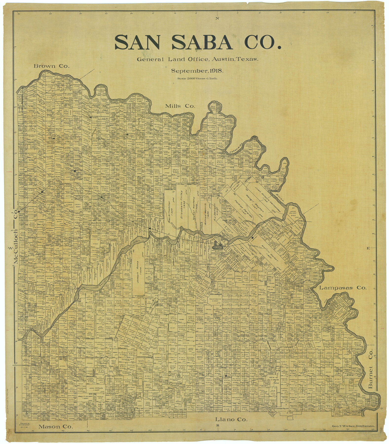
San Saba Co.
-
Map/Doc
63021
-
Collection
General Map Collection
-
Object Dates
1918 (Creation Date)
-
People and Organizations
Texas General Land Office (Publisher)
George T. Wicker (Draftsman)
George T. Wicker (Compiler)
-
Counties
San Saba
-
Subjects
County
-
Height x Width
47.4 x 41.6 inches
120.4 x 105.7 cm
-
Comments
Traced October 1, 1918 by G. T. Wicker.
Part of: General Map Collection
Hemphill County Working Sketch 33

Print $20.00
- Digital $50.00
Hemphill County Working Sketch 33
1976
Size 39.6 x 32.3 inches
Map/Doc 66128
Liberty County Working Sketch 86

Print $20.00
- Digital $50.00
Liberty County Working Sketch 86
1986
Size 30.7 x 34.7 inches
Map/Doc 70546
State Highway System of Texas Showing Condition of Improvement

Print $5.00
- Digital $50.00
State Highway System of Texas Showing Condition of Improvement
1929
Size 28.5 x 30.9 inches
Map/Doc 93720
Flight Mission No. BQR-9K, Frame 48, Brazoria County

Print $20.00
- Digital $50.00
Flight Mission No. BQR-9K, Frame 48, Brazoria County
1952
Size 18.7 x 22.2 inches
Map/Doc 84052
Crockett County Rolled Sketch 93

Print $20.00
- Digital $50.00
Crockett County Rolled Sketch 93
1979
Size 18.8 x 18.9 inches
Map/Doc 5633
Brewster County Rolled Sketch 114

Print $20.00
- Digital $50.00
Brewster County Rolled Sketch 114
1964
Size 11.7 x 17.7 inches
Map/Doc 5281
Township No. 2 South Range No. 20 West of the Indian Meridian

Print $20.00
- Digital $50.00
Township No. 2 South Range No. 20 West of the Indian Meridian
1875
Size 19.2 x 24.5 inches
Map/Doc 75180
Map of Val Verde County

Print $40.00
- Digital $50.00
Map of Val Verde County
1898
Size 80.7 x 42.7 inches
Map/Doc 16913
Map of Lavaca County

Print $20.00
- Digital $50.00
Map of Lavaca County
1866
Size 22.3 x 23.7 inches
Map/Doc 3802
Anderson County Working Sketch 33

Print $20.00
- Digital $50.00
Anderson County Working Sketch 33
1966
Size 30.8 x 29.9 inches
Map/Doc 67033
Notes for map of Montgomery County

Print $20.00
- Digital $50.00
Notes for map of Montgomery County
1844
Size 17.6 x 21.9 inches
Map/Doc 78370
Midland County Working Sketch 8

Print $20.00
- Digital $50.00
Midland County Working Sketch 8
1950
Size 41.4 x 32.9 inches
Map/Doc 70988
You may also like
Udell -V- Hughes Sketch

Print $20.00
- Digital $50.00
Udell -V- Hughes Sketch
Size 28.8 x 19.4 inches
Map/Doc 90481
Jim Wells County Working Sketch 14

Print $20.00
- Digital $50.00
Jim Wells County Working Sketch 14
1981
Size 18.1 x 30.0 inches
Map/Doc 66612
Lavaca County

Print $40.00
- Digital $50.00
Lavaca County
1946
Size 51.1 x 42.8 inches
Map/Doc 73216
[B. S. & F. Block 1 and A. B. & M. Block 2]
![91815, [B. S. & F. Block 1 and A. B. & M. Block 2], Twichell Survey Records](https://historictexasmaps.com/wmedia_w700/maps/91815-1.tif.jpg)
Print $20.00
- Digital $50.00
[B. S. & F. Block 1 and A. B. & M. Block 2]
Size 14.0 x 21.5 inches
Map/Doc 91815
Shelby County

Print $20.00
- Digital $50.00
Shelby County
1945
Size 41.6 x 45.9 inches
Map/Doc 73288
Parker County Sketch File 49

Print $6.00
- Digital $50.00
Parker County Sketch File 49
Size 10.6 x 8.8 inches
Map/Doc 33618
San Patricio County Rolled Sketch 31

Print $20.00
- Digital $50.00
San Patricio County Rolled Sketch 31
1941
Size 43.1 x 42.6 inches
Map/Doc 9898
Duval County Working Sketch 1

Print $20.00
- Digital $50.00
Duval County Working Sketch 1
Size 24.6 x 36.4 inches
Map/Doc 76442
Map of Cherokee County

Print $20.00
- Digital $50.00
Map of Cherokee County
1871
Size 25.0 x 17.6 inches
Map/Doc 3388
Colorado County Sketch File 1

Print $40.00
- Digital $50.00
Colorado County Sketch File 1
1848
Size 13.0 x 16.1 inches
Map/Doc 18909
Webb County Sketch File 19

Print $15.00
- Digital $50.00
Webb County Sketch File 19
1902
Size 9.2 x 17.0 inches
Map/Doc 39822
San Patricio County Rolled Sketch 49

Print $20.00
- Digital $50.00
San Patricio County Rolled Sketch 49
1979
Size 19.7 x 17.7 inches
Map/Doc 7734