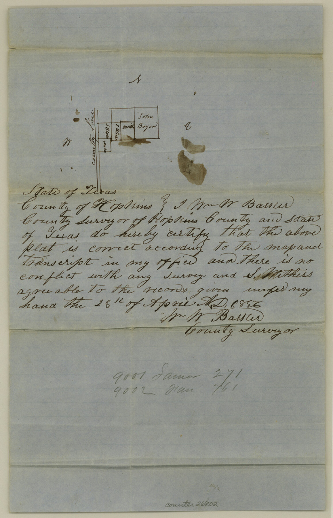
Hopkins County Sketch File 10a
[Sketch southwest of Sulphur Springs]
-
Map/Doc
26702
-
Collection
General Map Collection
-
Object Dates
4/26/1856 (Creation Date)
-
People and Organizations
William W. Barker (Surveyor/Engineer)
-
Counties
Hopkins
-
Subjects
Surveying Sketch File
-
Height x Width
12.2 x 7.8 inches
31.0 x 19.8 cm
-
Medium
paper, manuscript
Part of: General Map Collection
Zavala County Sketch File 17

Print $64.00
- Digital $50.00
Zavala County Sketch File 17
1900
Size 9.1 x 10.1 inches
Map/Doc 41324
Schleicher County

Print $20.00
- Digital $50.00
Schleicher County
1940
Size 28.8 x 41.2 inches
Map/Doc 77418
Chambers County NRC Article 33.136 Sketch 12

Print $30.00
- Digital $50.00
Chambers County NRC Article 33.136 Sketch 12
2020
Size 24.0 x 35.9 inches
Map/Doc 96441
Shackelford County

Print $20.00
- Digital $50.00
Shackelford County
1972
Size 42.8 x 36.3 inches
Map/Doc 73287
Culberson County Sketch File 41

Print $20.00
- Digital $50.00
Culberson County Sketch File 41
1920
Size 12.5 x 8.8 inches
Map/Doc 20312
Right-of-Way and Track Map, Texas State Railroad operated by the T. and N. O. R.R. Co.

Print $40.00
- Digital $50.00
Right-of-Way and Track Map, Texas State Railroad operated by the T. and N. O. R.R. Co.
1917
Size 24.5 x 55.9 inches
Map/Doc 64177
Flight Mission No. DIX-8P, Frame 90, Aransas County

Print $20.00
- Digital $50.00
Flight Mission No. DIX-8P, Frame 90, Aransas County
1956
Size 18.6 x 22.4 inches
Map/Doc 83915
Historia de Nueva-España, escrita por su esclarecido conquistador Hernan Cortes, aumentada con otros documentos, y notas, por el ilustrissimo señor don Francisco Antonio Lorenzana, Arzobispo de Mexico

Historia de Nueva-España, escrita por su esclarecido conquistador Hernan Cortes, aumentada con otros documentos, y notas, por el ilustrissimo señor don Francisco Antonio Lorenzana, Arzobispo de Mexico
1770
Map/Doc 97351
Real County Working Sketch 78

Print $20.00
- Digital $50.00
Real County Working Sketch 78
1980
Size 33.9 x 35.5 inches
Map/Doc 71970
Dimmit County Rolled Sketch 22

Print $20.00
- Digital $50.00
Dimmit County Rolled Sketch 22
2012
Size 31.5 x 24.0 inches
Map/Doc 93629
Cottle County Rolled Sketch 14

Print $741.00
- Digital $50.00
Cottle County Rolled Sketch 14
1882
Size 10.8 x 16.0 inches
Map/Doc 42369
Brewster County Rolled Sketch 28

Print $20.00
- Digital $50.00
Brewster County Rolled Sketch 28
1910
Size 25.6 x 29.4 inches
Map/Doc 5215
You may also like
Map of north end of Brazos Island

Print $20.00
- Digital $50.00
Map of north end of Brazos Island
1845
Size 24.3 x 18.3 inches
Map/Doc 72919
Val Verde County Sketch File 28

Print $20.00
- Digital $50.00
Val Verde County Sketch File 28
Size 29.9 x 25.1 inches
Map/Doc 12573
McMullen County Working Sketch 58

Print $40.00
- Digital $50.00
McMullen County Working Sketch 58
1984
Size 61.2 x 40.0 inches
Map/Doc 70759
Concho County Sketch File 18

Print $32.00
- Digital $50.00
Concho County Sketch File 18
1898
Size 9.1 x 4.4 inches
Map/Doc 19137
McMullen County Boundary File 7

Print $5.00
- Digital $50.00
McMullen County Boundary File 7
Size 7.2 x 17.0 inches
Map/Doc 57017
Midland County Sketch File 2

Print $20.00
- Digital $50.00
Midland County Sketch File 2
1886
Size 16.3 x 17.6 inches
Map/Doc 12080
Anderson County Working Sketch 6

Print $20.00
- Digital $50.00
Anderson County Working Sketch 6
1913
Size 24.7 x 26.3 inches
Map/Doc 67005
Brewster County Rolled Sketch 97

Print $20.00
- Digital $50.00
Brewster County Rolled Sketch 97
1952
Size 31.6 x 30.7 inches
Map/Doc 5254
[E. T. Ry. Blk. 1]
![89795, [E. T. Ry. Blk. 1], Twichell Survey Records](https://historictexasmaps.com/wmedia_w700/maps/89795-1.tif.jpg)
Print $40.00
- Digital $50.00
[E. T. Ry. Blk. 1]
Size 40.6 x 51.2 inches
Map/Doc 89795
Galveston County NRC Article 33.136 Sketch 95

Print $40.00
Galveston County NRC Article 33.136 Sketch 95
2024
Map/Doc 97368
Photo Index of Texas Coast - Sheet 6 of 6

Print $20.00
- Digital $50.00
Photo Index of Texas Coast - Sheet 6 of 6
1954
Size 20.0 x 24.0 inches
Map/Doc 83444
Flight Mission No. DIX-8P, Frame 95, Aransas County

Print $20.00
- Digital $50.00
Flight Mission No. DIX-8P, Frame 95, Aransas County
1956
Size 18.4 x 22.3 inches
Map/Doc 83920