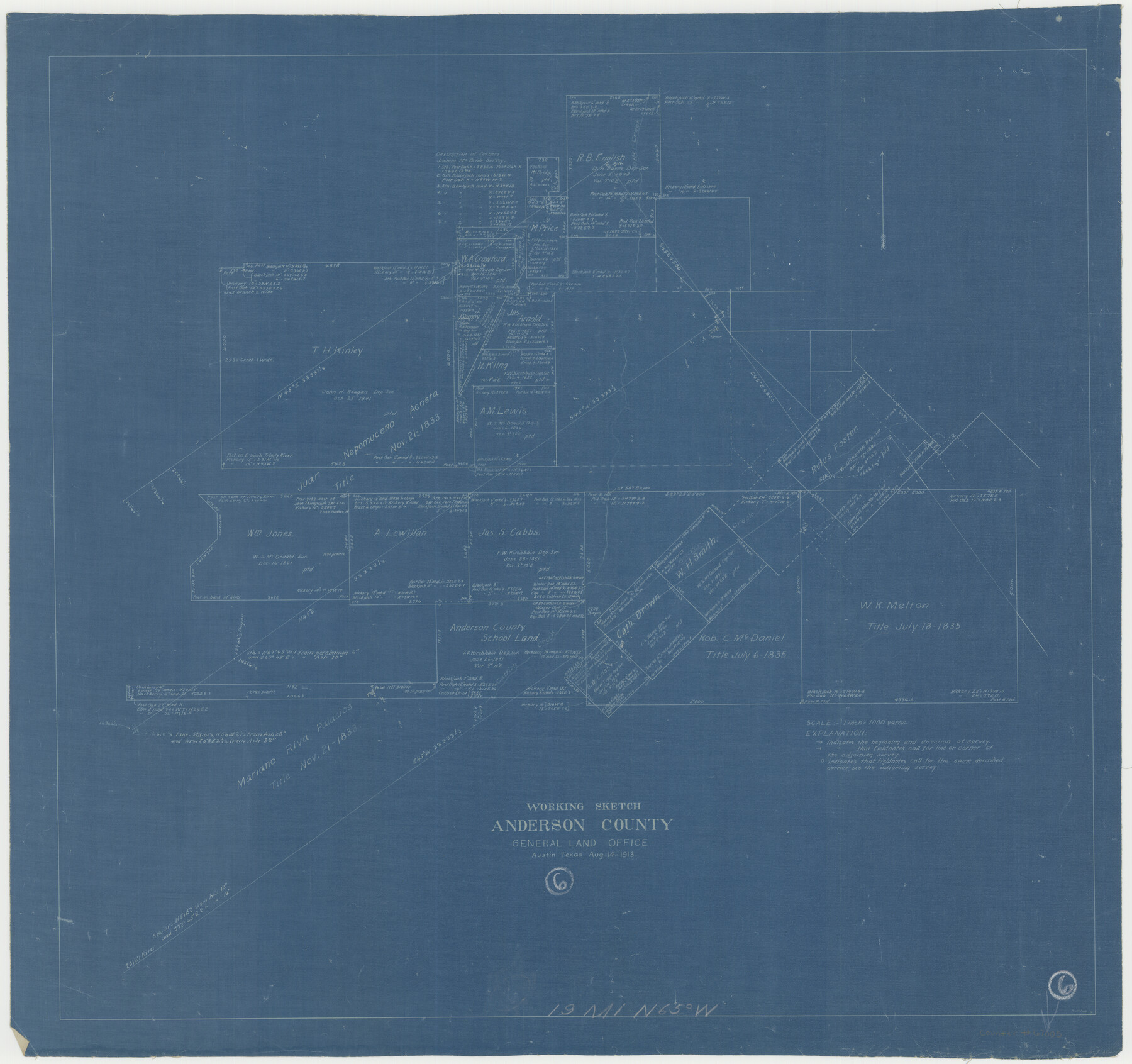
Anderson County Working Sketch 6
-
Map/Doc
67005
-
Collection
General Map Collection
-
Object Dates
8/14/1913 (Creation Date)
-
People and Organizations
John W. Pritchett (Draftsman)
-
Counties
Anderson
-
Subjects
Surveying Working Sketch
-
Height x Width
24.7 x 26.3 inches
62.7 x 66.8 cm
-
Scale
1" = 1000 varas
-
Comments
Surveys located about 19 miles North 65 degrees West of Palestine, Texas.
Part of: General Map Collection
Liberty County Working Sketch 31

Print $20.00
- Digital $50.00
Liberty County Working Sketch 31
1942
Size 23.1 x 42.9 inches
Map/Doc 70490
Oldham County Working Sketch 8

Print $20.00
- Digital $50.00
Oldham County Working Sketch 8
1982
Size 33.4 x 35.8 inches
Map/Doc 71330
Bowie County Sketch File 1

Print $8.00
- Digital $50.00
Bowie County Sketch File 1
Size 8.6 x 10.0 inches
Map/Doc 14833
[Right of Way & Track Map, The Texas & Pacific Ry. Co. Main Line]
![64680, [Right of Way & Track Map, The Texas & Pacific Ry. Co. Main Line], General Map Collection](https://historictexasmaps.com/wmedia_w700/maps/64680.tif.jpg)
Print $20.00
- Digital $50.00
[Right of Way & Track Map, The Texas & Pacific Ry. Co. Main Line]
Size 11.0 x 19.0 inches
Map/Doc 64680
Right of Way and Track Map of The Missouri, Kansas & Texas Railway of Texas

Print $40.00
- Digital $50.00
Right of Way and Track Map of The Missouri, Kansas & Texas Railway of Texas
1918
Size 25.7 x 107.8 inches
Map/Doc 64532
Real County Sketch File 10

Print $6.00
- Digital $50.00
Real County Sketch File 10
1932
Size 10.3 x 15.0 inches
Map/Doc 35063
Jefferson County NRC Article 33.136 Location Key Sheet

Print $20.00
- Digital $50.00
Jefferson County NRC Article 33.136 Location Key Sheet
1974
Size 27.0 x 23.0 inches
Map/Doc 77029
Schleicher County Sketch File 14

Print $12.00
- Digital $50.00
Schleicher County Sketch File 14
1917
Size 12.9 x 8.3 inches
Map/Doc 36498
El Paso County Working Sketch 55

Print $20.00
- Digital $50.00
El Paso County Working Sketch 55
1992
Size 44.2 x 36.3 inches
Map/Doc 69077
Harrison County Sketch File 3

Print $8.00
- Digital $50.00
Harrison County Sketch File 3
Size 13.0 x 8.3 inches
Map/Doc 26036
Colorado River, Lane City Sheet

Print $4.00
- Digital $50.00
Colorado River, Lane City Sheet
1941
Size 27.0 x 29.9 inches
Map/Doc 65316
Shelby County Rolled Sketch 18

Print $20.00
- Digital $50.00
Shelby County Rolled Sketch 18
1975
Size 36.2 x 40.7 inches
Map/Doc 9926
You may also like
Oldham County

Print $40.00
- Digital $50.00
Oldham County
1925
Size 42.6 x 51.5 inches
Map/Doc 77387
Flight Mission No. DQN-1K, Frame 112, Calhoun County

Print $20.00
- Digital $50.00
Flight Mission No. DQN-1K, Frame 112, Calhoun County
1953
Size 18.6 x 22.3 inches
Map/Doc 84179
Controlled Mosaic by Jack Amman Photogrammetric Engineers, Inc - Sheet 12

Print $20.00
- Digital $50.00
Controlled Mosaic by Jack Amman Photogrammetric Engineers, Inc - Sheet 12
1954
Size 20.0 x 24.0 inches
Map/Doc 83456
Newton County Aerial Photograph Index Sheet 6

Print $20.00
- Digital $50.00
Newton County Aerial Photograph Index Sheet 6
1953
Size 24.0 x 18.4 inches
Map/Doc 83735
Flight Mission No. DAG-18K, Frame 75, Matagorda County

Print $20.00
- Digital $50.00
Flight Mission No. DAG-18K, Frame 75, Matagorda County
1952
Size 18.5 x 19.1 inches
Map/Doc 86368
Crockett County Sketch File 72

Print $14.00
- Digital $50.00
Crockett County Sketch File 72
Size 14.0 x 8.6 inches
Map/Doc 19862
Amerique Septentrionale

Print $20.00
- Digital $50.00
Amerique Septentrionale
1650
Size 17.2 x 23.1 inches
Map/Doc 93684
Flight Mission No. DCL-7C, Frame 79, Kenedy County

Print $20.00
- Digital $50.00
Flight Mission No. DCL-7C, Frame 79, Kenedy County
1943
Size 15.2 x 15.2 inches
Map/Doc 86065
![91800, [Block M-19], Twichell Survey Records](https://historictexasmaps.com/wmedia_w700/maps/91800-1.tif.jpg)
San Augustine County Working Sketch 11a

Print $20.00
- Digital $50.00
San Augustine County Working Sketch 11a
Size 18.8 x 24.4 inches
Map/Doc 63698
Brewster County Rolled Sketch 86

Print $20.00
- Digital $50.00
Brewster County Rolled Sketch 86
1940
Size 16.1 x 26.4 inches
Map/Doc 5247
Calhoun County Working Sketch 8

Print $20.00
- Digital $50.00
Calhoun County Working Sketch 8
1943
Size 33.9 x 34.8 inches
Map/Doc 67824