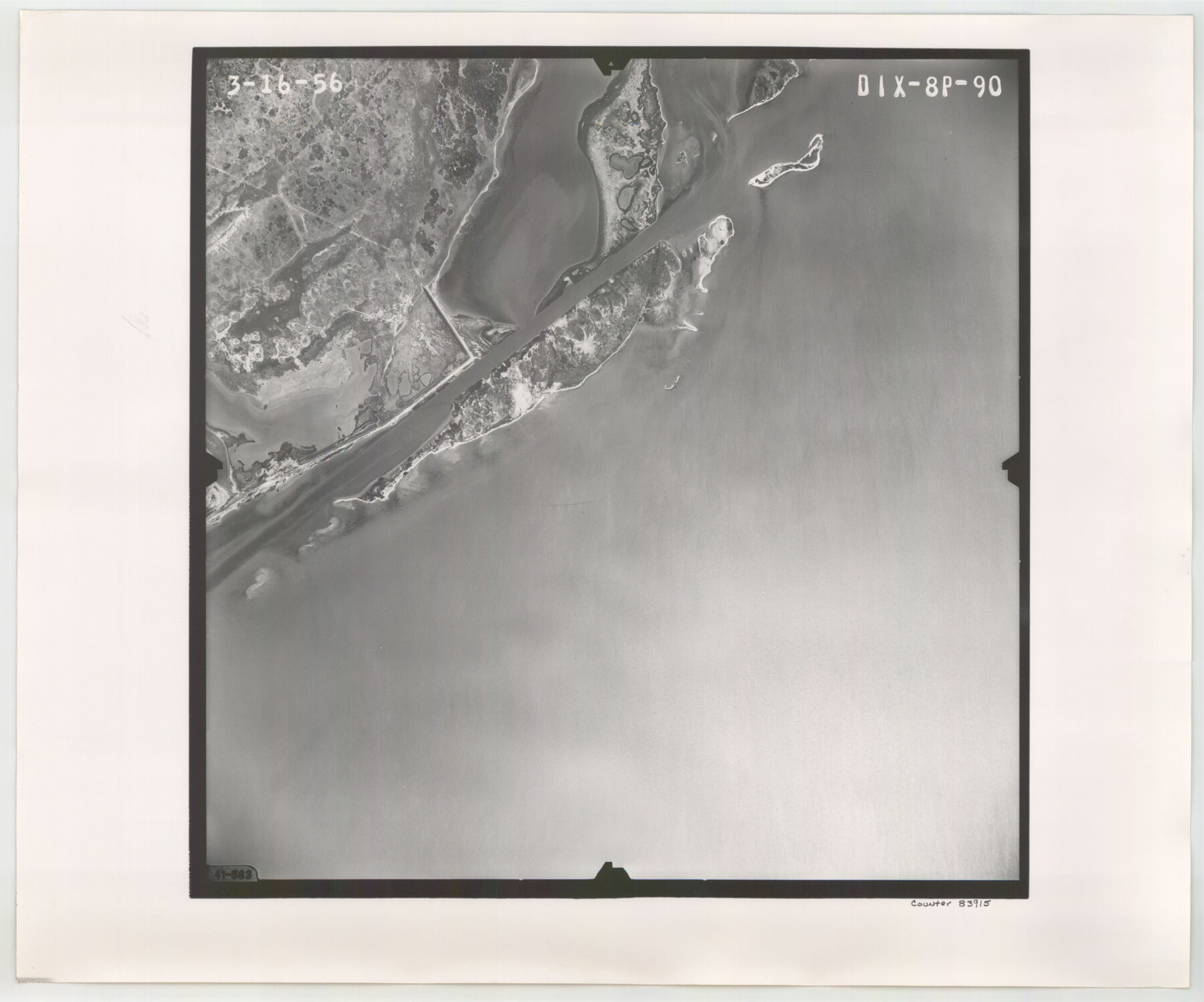
Flight Mission No. DIX-8P, Frame 90, Aransas County
DIX-8P-90
-
Map/Doc
83915
-
Collection
General Map Collection
-
Object Dates
1956/3/16 (Creation Date)
-
People and Organizations
U. S. Department of Agriculture (Publisher)
-
Counties
Aransas
-
Subjects
Aerial Photograph
-
Height x Width
18.6 x 22.4 inches
47.2 x 56.9 cm
-
Comments
Flown by V. L. Beavers and Associates of San Antonio, Texas.
Part of: General Map Collection
Calhoun County Boundary File 3

Print $8.00
- Digital $50.00
Calhoun County Boundary File 3
Size 11.3 x 8.7 inches
Map/Doc 50975
Travis County Working Sketch 28

Print $20.00
- Digital $50.00
Travis County Working Sketch 28
1955
Size 31.5 x 30.7 inches
Map/Doc 69412
Stonewall County

Print $20.00
- Digital $50.00
Stonewall County
1902
Size 41.8 x 40.4 inches
Map/Doc 16885
Uvalde County Working Sketch 66

Print $20.00
- Digital $50.00
Uvalde County Working Sketch 66
1942
Size 20.9 x 21.3 inches
Map/Doc 75968
Cottle County Working Sketch 7

Print $20.00
- Digital $50.00
Cottle County Working Sketch 7
1916
Size 28.4 x 30.4 inches
Map/Doc 68317
Sabine River, Watershed of the Sabine and Neches Rivers

Print $20.00
- Digital $50.00
Sabine River, Watershed of the Sabine and Neches Rivers
Size 39.5 x 36.0 inches
Map/Doc 65132
Map of the Lands Surveyed by the Memphis, El Paso & Pacific R.R. Company

Print $20.00
- Digital $50.00
Map of the Lands Surveyed by the Memphis, El Paso & Pacific R.R. Company
1860
Size 17.7 x 21.7 inches
Map/Doc 4851
[Rio Grande & Eagle Pass - Stockdale to Cuero]
![64048, [Rio Grande & Eagle Pass - Stockdale to Cuero], General Map Collection](https://historictexasmaps.com/wmedia_w700/maps/64048.tif.jpg)
Print $40.00
- Digital $50.00
[Rio Grande & Eagle Pass - Stockdale to Cuero]
Size 19.9 x 122.5 inches
Map/Doc 64048
Val Verde County Sketch File L

Print $26.00
- Digital $50.00
Val Verde County Sketch File L
1919
Size 12.4 x 9.1 inches
Map/Doc 39262
Ward County Working Sketch 21

Print $20.00
- Digital $50.00
Ward County Working Sketch 21
1953
Size 20.9 x 14.7 inches
Map/Doc 72327
Sabine County Working Sketch 13

Print $20.00
- Digital $50.00
Sabine County Working Sketch 13
1935
Size 35.3 x 44.2 inches
Map/Doc 63684
Flight Mission No. CGI-3N, Frame 186, Cameron County

Print $20.00
- Digital $50.00
Flight Mission No. CGI-3N, Frame 186, Cameron County
1954
Size 18.6 x 22.3 inches
Map/Doc 84650
You may also like
Hudspeth County Working Sketch 57

Print $20.00
- Digital $50.00
Hudspeth County Working Sketch 57
1992
Size 9.6 x 26.5 inches
Map/Doc 66342
Current Miscellaneous File 5

Print $8.00
- Digital $50.00
Current Miscellaneous File 5
1946
Size 11.3 x 8.8 inches
Map/Doc 73727
Flight Mission No. BRA-7M, Frame 13, Jefferson County

Print $20.00
- Digital $50.00
Flight Mission No. BRA-7M, Frame 13, Jefferson County
1953
Size 18.6 x 22.4 inches
Map/Doc 85464
Nueces County Sketch File 12b

Print $8.00
- Digital $50.00
Nueces County Sketch File 12b
1889
Size 14.2 x 8.8 inches
Map/Doc 32530
Nueces County Rolled Sketch 110

Print $20.00
- Digital $50.00
Nueces County Rolled Sketch 110
1990
Size 24.1 x 37.5 inches
Map/Doc 7117
Brazos River, Brazos River Sheet 2

Print $20.00
- Digital $50.00
Brazos River, Brazos River Sheet 2
1926
Size 22.3 x 29.4 inches
Map/Doc 69666
Dallas County Boundary File 7 and 7a and 7b

Print $8.00
- Digital $50.00
Dallas County Boundary File 7 and 7a and 7b
Size 11.2 x 8.6 inches
Map/Doc 52291
Right of Way & Track Map San Antonio & Aransas Pass Railway Co.

Print $40.00
- Digital $50.00
Right of Way & Track Map San Antonio & Aransas Pass Railway Co.
1919
Size 25.2 x 56.7 inches
Map/Doc 64040
Harris County Sketch File B

Print $4.00
- Digital $50.00
Harris County Sketch File B
1860
Size 8.0 x 5.5 inches
Map/Doc 25309
Pecos County Rolled Sketch 179

Print $20.00
- Digital $50.00
Pecos County Rolled Sketch 179
1980
Size 28.0 x 28.2 inches
Map/Doc 7299
[Surveying Sketch of Northern Portion of Hutchinson County]
![5065, [Surveying Sketch of Northern Portion of Hutchinson County], Maddox Collection](https://historictexasmaps.com/wmedia_w700/maps/5065.tif.jpg)
Print $20.00
- Digital $50.00
[Surveying Sketch of Northern Portion of Hutchinson County]
1890
Size 26.5 x 42.5 inches
Map/Doc 5065
Jones County Sketch File 20

Print $4.00
- Digital $50.00
Jones County Sketch File 20
1875
Size 14.2 x 8.8 inches
Map/Doc 28543