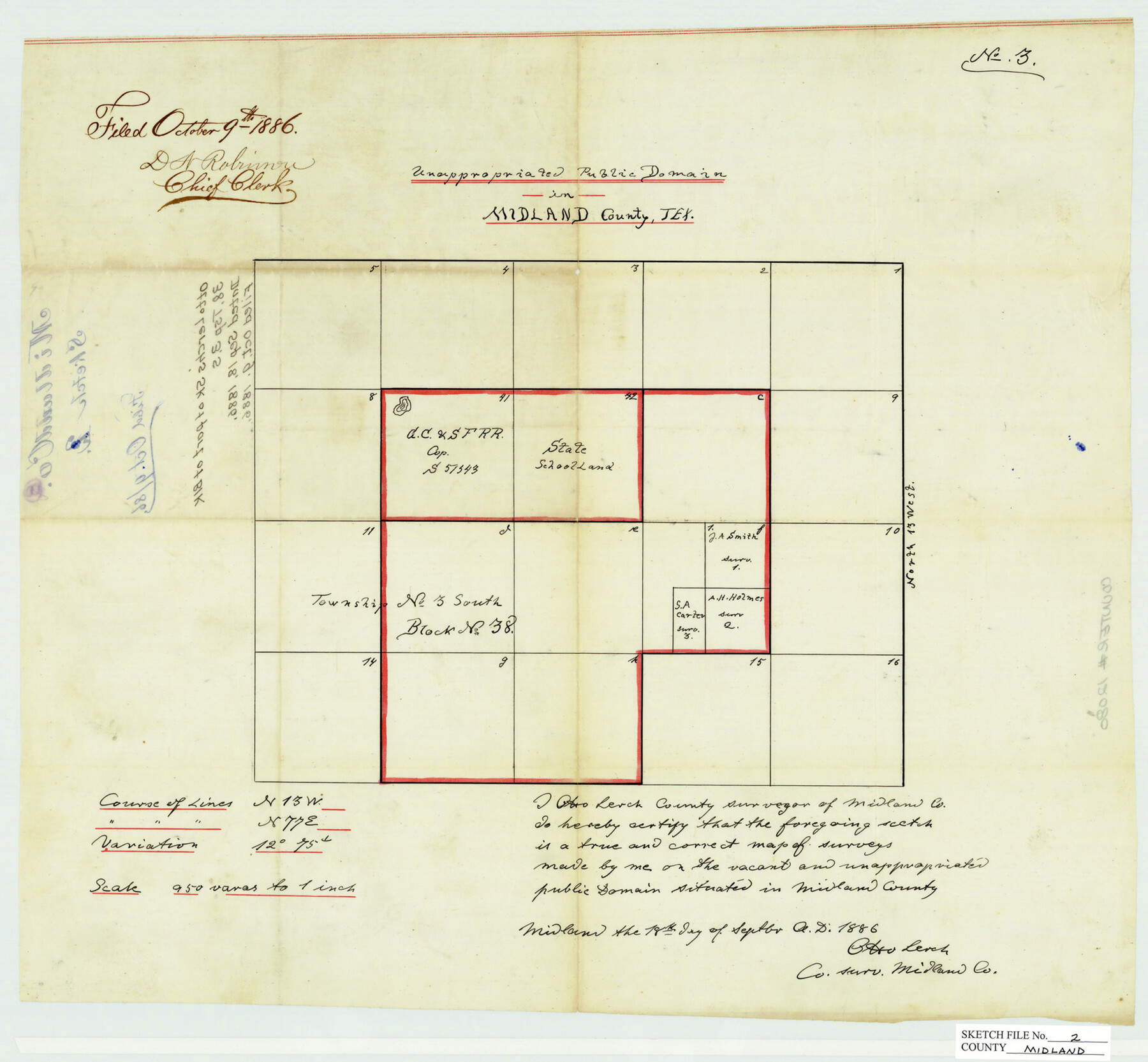
Midland County Sketch File 2
Unappropriated Public Domain in Midland County, Texas
-
Map/Doc
12080
-
Collection
General Map Collection
-
Object Dates
9/17/1886 (Creation Date)
10/9/1886 (File Date)
-
People and Organizations
Otto Lerch (Surveyor/Engineer)
-
Counties
Midland
-
Subjects
Surveying Sketch File
-
Height x Width
16.3 x 17.6 inches
41.4 x 44.7 cm
-
Medium
paper, manuscript
-
Scale
1:950
Part of: General Map Collection
Colorado County Sketch File 16

Print $4.00
- Digital $50.00
Colorado County Sketch File 16
Size 8.2 x 10.3 inches
Map/Doc 18945
Uvalde County Rolled Sketch A

Print $20.00
- Digital $50.00
Uvalde County Rolled Sketch A
1849
Size 21.7 x 25.8 inches
Map/Doc 8104
Hutchinson County Rolled Sketch 44-4

Print $20.00
- Digital $50.00
Hutchinson County Rolled Sketch 44-4
2002
Size 24.0 x 36.0 inches
Map/Doc 77540
Culberson County Sketch File 10

Print $4.00
- Digital $50.00
Culberson County Sketch File 10
1911
Size 14.6 x 9.0 inches
Map/Doc 20144
Dimmit County Rolled Sketch 22A

Print $20.00
- Digital $50.00
Dimmit County Rolled Sketch 22A
2012
Size 23.2 x 34.0 inches
Map/Doc 93630
[Surveys on the San Marcos River]
![149, [Surveys on the San Marcos River], General Map Collection](https://historictexasmaps.com/wmedia_w700/maps/149.tif.jpg)
Print $20.00
- Digital $50.00
[Surveys on the San Marcos River]
Size 14.1 x 12.4 inches
Map/Doc 149
Harris County Rolled Sketch 96C

Print $3.00
- Digital $50.00
Harris County Rolled Sketch 96C
Size 10.5 x 10.5 inches
Map/Doc 10653
Stonewall County Rolled Sketch 29

Print $20.00
- Digital $50.00
Stonewall County Rolled Sketch 29
Size 43.1 x 37.9 inches
Map/Doc 9969
Nueces County Sketch File 77a and 77b

Print $26.00
- Digital $50.00
Nueces County Sketch File 77a and 77b
1986
Size 11.1 x 8.6 inches
Map/Doc 33057
Bien & Sterner's New Rail Road Map of the United States and the Canadas compiled from the latest surveys & locations under the direction of Zerah Colburn Esq., editor of the Rail Road Advocate

Print $20.00
- Digital $50.00
Bien & Sterner's New Rail Road Map of the United States and the Canadas compiled from the latest surveys & locations under the direction of Zerah Colburn Esq., editor of the Rail Road Advocate
1855
Size 27.5 x 32.3 inches
Map/Doc 95963
Somervell Co.

Print $20.00
- Digital $50.00
Somervell Co.
1884
Size 28.0 x 26.8 inches
Map/Doc 63040
San Patricio County Sketch File 50

Print $8.00
- Digital $50.00
San Patricio County Sketch File 50
1873
Size 14.4 x 8.8 inches
Map/Doc 36371
You may also like
Montague County

Print $20.00
- Digital $50.00
Montague County
1924
Size 47.0 x 34.2 inches
Map/Doc 66938
Galveston to Rio Grande

Print $20.00
- Digital $50.00
Galveston to Rio Grande
1941
Size 43.7 x 37.1 inches
Map/Doc 69957
Brewster County Working Sketch 76

Print $20.00
- Digital $50.00
Brewster County Working Sketch 76
1968
Size 30.3 x 31.4 inches
Map/Doc 67676
Coast Chart No. 212 - From Latitude 26° 33' to the Rio Grande Texas

Print $20.00
- Digital $50.00
Coast Chart No. 212 - From Latitude 26° 33' to the Rio Grande Texas
1886
Size 27.7 x 18.2 inches
Map/Doc 72827
Chart showing the positions of the lights in the Eighth L. H. District extending from the Perdido River, Florida to the Rio Grande, Texas

Print $20.00
- Digital $50.00
Chart showing the positions of the lights in the Eighth L. H. District extending from the Perdido River, Florida to the Rio Grande, Texas
1876
Size 24.7 x 18.2 inches
Map/Doc 72682
Flight Mission No. DIX-6P, Frame 122, Aransas County

Print $20.00
- Digital $50.00
Flight Mission No. DIX-6P, Frame 122, Aransas County
1956
Size 19.1 x 22.4 inches
Map/Doc 83828
Collin County Sketch File 7

Print $40.00
- Digital $50.00
Collin County Sketch File 7
1852
Size 17.3 x 14.0 inches
Map/Doc 18866
Travis County Appraisal District Plat Map 3_0404

Print $20.00
- Digital $50.00
Travis County Appraisal District Plat Map 3_0404
Size 21.5 x 26.4 inches
Map/Doc 94226
Comal County Working Sketch 10

Print $20.00
- Digital $50.00
Comal County Working Sketch 10
1974
Size 28.8 x 27.9 inches
Map/Doc 68176
Ellwood Farms Subdivision Number 2 of the Spade Ranch Lamb and Hale Counties, Texas

Print $20.00
- Digital $50.00
Ellwood Farms Subdivision Number 2 of the Spade Ranch Lamb and Hale Counties, Texas
Size 22.2 x 31.4 inches
Map/Doc 92258
Polk County Sketch File 15

Print $8.00
- Digital $50.00
Polk County Sketch File 15
Size 12.7 x 8.4 inches
Map/Doc 34157
Archer County Sketch File 27

Print $40.00
- Digital $50.00
Archer County Sketch File 27
Size 19.1 x 21.1 inches
Map/Doc 10833