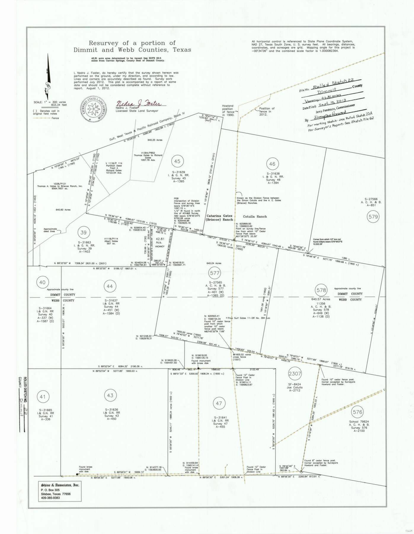
Dimmit County Rolled Sketch 22
Resurvey of a portion of Dimmit and Webb Counties, Texas
-
Map/Doc
93629
-
Collection
General Map Collection
-
Object Dates
2012/8/1 (Creation Date)
2013/9/10 (File Date)
-
People and Organizations
Nedra J. Foster (Surveyor/Engineer)
-
Counties
Dimmit Webb
-
Subjects
Surveying Rolled Sketch
-
Height x Width
31.5 x 24.0 inches
80.0 x 61.0 cm
-
Medium
mylar, print
-
Scale
1" = 300 varas
-
Comments
See Dimmit County Rolled Sketch 22A (93630) for related sketch and Dimmit County Sketch File 62 (93631) for surveyor's report.
Related maps
Dimmit County Rolled Sketch 22A

Print $20.00
- Digital $50.00
Dimmit County Rolled Sketch 22A
2012
Size 23.2 x 34.0 inches
Map/Doc 93630
Dimmit County Sketch File 62

Print $8.00
- Digital $50.00
Dimmit County Sketch File 62
2012
Size 11.0 x 8.5 inches
Map/Doc 93631
Part of: General Map Collection
Upshur County Sketch File 12

Print $8.00
- Digital $50.00
Upshur County Sketch File 12
Size 10.3 x 8.0 inches
Map/Doc 38751
Henderson County Sketch File 3

Print $4.00
- Digital $50.00
Henderson County Sketch File 3
1852
Size 10.3 x 8.4 inches
Map/Doc 26321
Haskell County Working Sketch 3

Print $20.00
- Digital $50.00
Haskell County Working Sketch 3
1920
Size 41.4 x 21.9 inches
Map/Doc 66061
[Redfish Bay, Aransas Pass, and part of Mustang Island]
![83009, [Redfish Bay, Aransas Pass, and part of Mustang Island], General Map Collection](https://historictexasmaps.com/wmedia_w700/maps/83009.tif.jpg)
Print $40.00
- Digital $50.00
[Redfish Bay, Aransas Pass, and part of Mustang Island]
1930
Size 51.0 x 46.5 inches
Map/Doc 83009
Refugio County Sketch File 26

Print $4.00
- Digital $50.00
Refugio County Sketch File 26
Size 12.9 x 8.4 inches
Map/Doc 35292
Sectional Map No. 2 of the lands and the line of the Texas & Pacific Ry. Co. in Howard, Martin, Andrews, Midland and Tom Green Counties

Print $20.00
- Digital $50.00
Sectional Map No. 2 of the lands and the line of the Texas & Pacific Ry. Co. in Howard, Martin, Andrews, Midland and Tom Green Counties
1885
Size 19.1 x 23.3 inches
Map/Doc 4862

Cameron County Rolled Sketch 27

Print $20.00
- Digital $50.00
Cameron County Rolled Sketch 27
Size 19.0 x 39.5 inches
Map/Doc 5392

Kinney County Working Sketch 45

Print $20.00
- Digital $50.00
Kinney County Working Sketch 45
1978
Size 28.6 x 26.5 inches
Map/Doc 70227
Flight Mission No. BRE-1P, Frame 48, Nueces County

Print $20.00
- Digital $50.00
Flight Mission No. BRE-1P, Frame 48, Nueces County
1956
Size 18.4 x 22.1 inches
Map/Doc 86637
Midland County Sketch File 4

Print $20.00
- Digital $50.00
Midland County Sketch File 4
1886
Size 16.3 x 18.9 inches
Map/Doc 12082
You may also like
Calhoun County NRC Article 33.136 Sketch 7

Print $63.00
- Digital $50.00
Calhoun County NRC Article 33.136 Sketch 7
2016
Size 17.1 x 21.8 inches
Map/Doc 94867
Flight Mission No. DCL-6C, Frame 173, Kenedy County

Print $20.00
- Digital $50.00
Flight Mission No. DCL-6C, Frame 173, Kenedy County
1943
Size 18.6 x 22.4 inches
Map/Doc 85985
Leon County Working Sketch 28

Print $20.00
- Digital $50.00
Leon County Working Sketch 28
1971
Size 25.0 x 30.1 inches
Map/Doc 70427
Reeves County

Print $40.00
- Digital $50.00
Reeves County
1945
Size 48.3 x 39.8 inches
Map/Doc 73273
Caldwell County Working Sketch 5

Print $20.00
- Digital $50.00
Caldwell County Working Sketch 5
1940
Size 19.9 x 27.4 inches
Map/Doc 67835

Tyler County Rolled Sketch 9

Print $20.00
- Digital $50.00
Tyler County Rolled Sketch 9
Size 43.3 x 25.6 inches
Map/Doc 8059

Foard County Rolled Sketch 13

Print $20.00
- Digital $50.00
Foard County Rolled Sketch 13
1958
Size 25.2 x 31.4 inches
Map/Doc 5887
1882 Map of the Texas & Pacific R-Y Reserve

Print $20.00
- Digital $50.00
1882 Map of the Texas & Pacific R-Y Reserve
1887
Size 44.1 x 42.1 inches
Map/Doc 83560
Van Zandt County Working Sketch 14

Print $20.00
- Digital $50.00
Van Zandt County Working Sketch 14
1982
Size 13.2 x 11.5 inches
Map/Doc 72264
Liberty County Sketch File 9

Print $8.00
- Digital $50.00
Liberty County Sketch File 9
1857
Size 8.0 x 8.1 inches
Map/Doc 29900