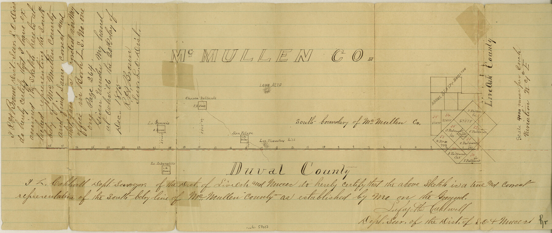
McMullen County Boundary File 7
[Sketch of McMullen-Duval Boundary line]
-
Map/Doc
57017
-
Collection
General Map Collection
-
Counties
McMullen
-
Subjects
County Boundaries
-
Height x Width
7.2 x 17.0 inches
18.3 x 43.2 cm
Part of: General Map Collection
Crockett County Sketch File 76

Print $2.00
- Digital $50.00
Crockett County Sketch File 76
1933
Size 11.2 x 8.6 inches
Map/Doc 19876
Harris County Sketch File 59a

Print $20.00
- Digital $50.00
Harris County Sketch File 59a
Size 25.1 x 40.1 inches
Map/Doc 10479
Sabine and Neches Rivers

Print $20.00
- Digital $50.00
Sabine and Neches Rivers
1976
Size 19.8 x 44.9 inches
Map/Doc 69819
Duval County Sketch File 6a

Print $20.00
- Digital $50.00
Duval County Sketch File 6a
1875
Size 10.9 x 22.9 inches
Map/Doc 11382
Edwards County Rolled Sketch 20

Print $20.00
- Digital $50.00
Edwards County Rolled Sketch 20
1947
Size 31.6 x 40.4 inches
Map/Doc 8844
National Map Company's New Road Survey of the United States Showing Main Highways

Print $20.00
- Digital $50.00
National Map Company's New Road Survey of the United States Showing Main Highways
Size 44.3 x 38.2 inches
Map/Doc 4674
Uvalde County Rolled Sketch 24

Print $20.00
- Digital $50.00
Uvalde County Rolled Sketch 24
2014
Size 16.2 x 16.1 inches
Map/Doc 93722
Ector County Rolled Sketch WA

Print $20.00
- Digital $50.00
Ector County Rolled Sketch WA
Size 26.2 x 30.0 inches
Map/Doc 5780
Presidio County Working Sketch 150

Print $20.00
- Digital $50.00
Presidio County Working Sketch 150
2002
Size 24.0 x 23.5 inches
Map/Doc 93490
Sabine County Boundary File 1

Print $96.00
- Digital $50.00
Sabine County Boundary File 1
Size 14.4 x 8.8 inches
Map/Doc 58530
Flight Mission No. DAG-24K, Frame 39, Matagorda County

Print $20.00
- Digital $50.00
Flight Mission No. DAG-24K, Frame 39, Matagorda County
1953
Size 18.5 x 22.3 inches
Map/Doc 86526
Texas State Boundary Line 8

Print $170.00
Texas State Boundary Line 8
2000
Size 11.3 x 8.8 inches
Map/Doc 75054
You may also like
Gillespie County Sketch File 6

Print $4.00
- Digital $50.00
Gillespie County Sketch File 6
Size 6.4 x 11.0 inches
Map/Doc 24139
Hansford County Boundary File 2

Print $14.00
- Digital $50.00
Hansford County Boundary File 2
Size 9.3 x 4.9 inches
Map/Doc 54245
[Kent County Block 4, Sections 33 and 46, Block 97, Sections 771 and 772]
![92192, [Kent County Block 4, Sections 33 and 46, Block 97, Sections 771 and 772], Twichell Survey Records](https://historictexasmaps.com/wmedia_w700/maps/92192-1.tif.jpg)
Print $2.00
- Digital $50.00
[Kent County Block 4, Sections 33 and 46, Block 97, Sections 771 and 772]
1951
Size 8.7 x 15.6 inches
Map/Doc 92192
Crosby County Sketch File 25

Print $12.00
- Digital $50.00
Crosby County Sketch File 25
1912
Size 11.2 x 8.7 inches
Map/Doc 20093
Map of Burleson County

Print $20.00
- Digital $50.00
Map of Burleson County
1867
Size 19.1 x 30.0 inches
Map/Doc 4511
Cass County Working Sketch 25

Print $20.00
- Digital $50.00
Cass County Working Sketch 25
1974
Size 46.5 x 35.8 inches
Map/Doc 67928
Trinity County Sketch File 4

Print $24.00
- Digital $50.00
Trinity County Sketch File 4
1858
Size 8.4 x 7.7 inches
Map/Doc 38501
Gillespie County Rolled Sketch O

Print $20.00
- Digital $50.00
Gillespie County Rolled Sketch O
1846
Size 42.6 x 20.0 inches
Map/Doc 6007
Delta County Working Sketch Graphic Index

Print $20.00
- Digital $50.00
Delta County Working Sketch Graphic Index
1942
Size 25.3 x 39.2 inches
Map/Doc 76520
General Highway Map. Detail of Cities and Towns in McLennan County, Texas [Waco and vicinity]
![79590, General Highway Map. Detail of Cities and Towns in McLennan County, Texas [Waco and vicinity], Texas State Library and Archives](https://historictexasmaps.com/wmedia_w700/maps/79590.tif.jpg)
Print $20.00
General Highway Map. Detail of Cities and Towns in McLennan County, Texas [Waco and vicinity]
1961
Size 18.1 x 24.6 inches
Map/Doc 79590
Flight Mission No. BRA-3M, Frame 190, Jefferson County

Print $20.00
- Digital $50.00
Flight Mission No. BRA-3M, Frame 190, Jefferson County
1953
Size 18.6 x 22.3 inches
Map/Doc 85405
