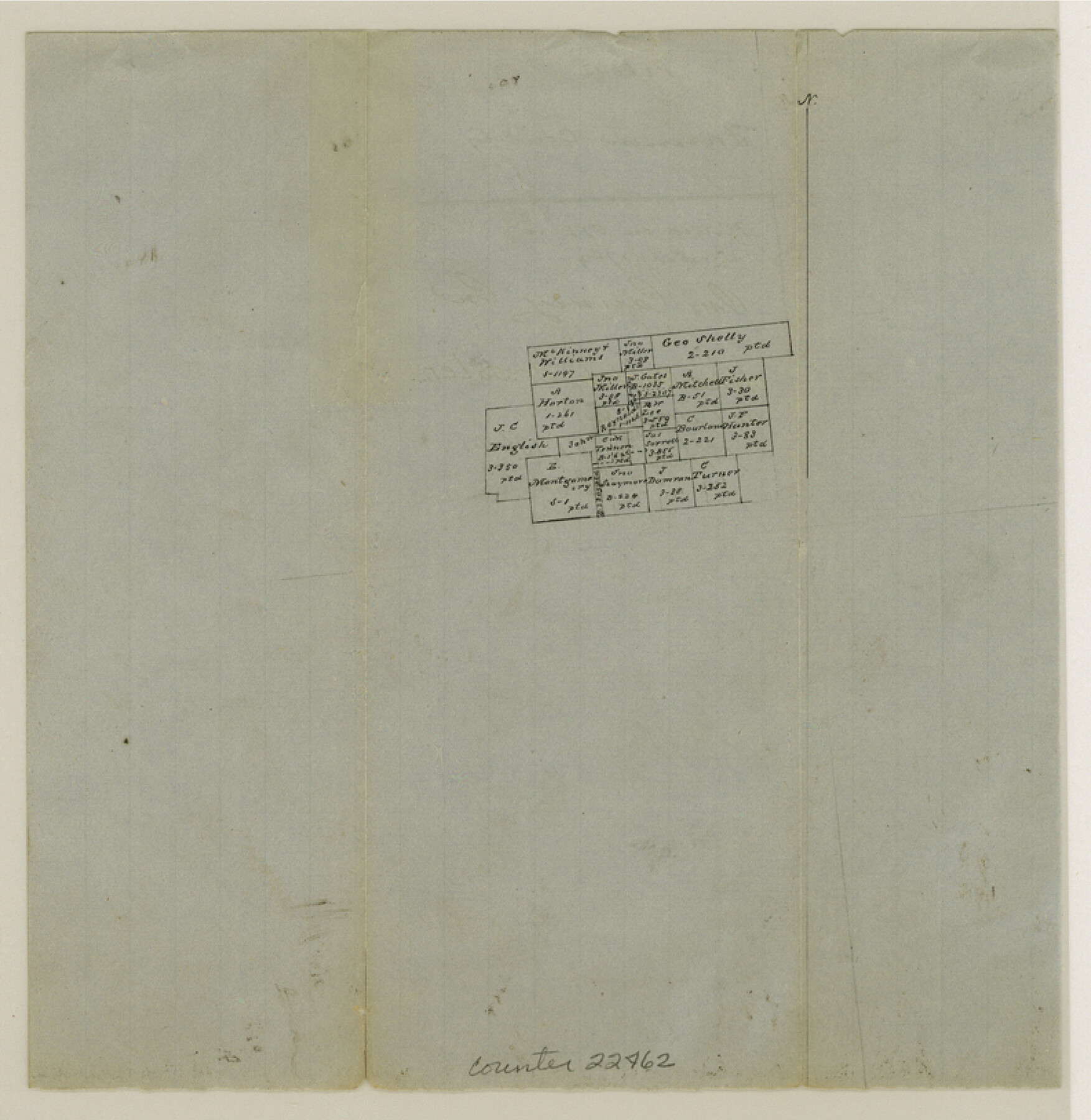
Fannin County Sketch File 13
[Office sketch of surveys on Caney Creek]
-
Map/Doc
22462
-
Collection
General Map Collection
-
Object Dates
1864/9/1 (File Date)
-
People and Organizations
Pressler (Surveyor/Engineer)
-
Counties
Fannin
-
Subjects
Surveying Sketch File
-
Height x Width
8.1 x 7.9 inches
20.6 x 20.1 cm
-
Medium
paper, manuscript
-
Features
[Caney Creek]
Part of: General Map Collection
Dickens County Working Sketch 9

Print $20.00
- Digital $50.00
Dickens County Working Sketch 9
1947
Size 18.5 x 29.6 inches
Map/Doc 68657
Trinity River, Big Creek Sheet

Print $40.00
- Digital $50.00
Trinity River, Big Creek Sheet
1924
Size 48.0 x 36.4 inches
Map/Doc 65179
Webb County Rolled Sketch 60

Print $20.00
- Digital $50.00
Webb County Rolled Sketch 60
1947
Size 30.0 x 33.8 inches
Map/Doc 8211
Matagorda County Rolled Sketch 29

Print $20.00
- Digital $50.00
Matagorda County Rolled Sketch 29
1936
Size 36.6 x 27.2 inches
Map/Doc 6691
Official Map of the City of Bryan from Actual Survey [West Part]
![76864, Official Map of the City of Bryan from Actual Survey [West Part], General Map Collection](https://historictexasmaps.com/wmedia_w700/maps/76864.tif.jpg)
Print $40.00
- Digital $50.00
Official Map of the City of Bryan from Actual Survey [West Part]
1898
Size 52.5 x 27.4 inches
Map/Doc 76864
Terrell County Rolled Sketch 30

Print $40.00
- Digital $50.00
Terrell County Rolled Sketch 30
1931
Size 38.9 x 49.0 inches
Map/Doc 10735
Map of Kinney County

Print $40.00
- Digital $50.00
Map of Kinney County
1889
Size 50.1 x 41.1 inches
Map/Doc 16869
Sherman County Rolled Sketch 12

Print $40.00
- Digital $50.00
Sherman County Rolled Sketch 12
1951
Size 63.9 x 11.3 inches
Map/Doc 10611
Flight Mission No. DQN-2K, Frame 189, Calhoun County

Print $20.00
- Digital $50.00
Flight Mission No. DQN-2K, Frame 189, Calhoun County
1953
Size 16.1 x 16.0 inches
Map/Doc 84330
Map of Taylor County

Print $20.00
- Digital $50.00
Map of Taylor County
1858
Size 24.0 x 25.3 inches
Map/Doc 4070

Fayette County Boundary File 3

Print $29.00
- Digital $50.00
Fayette County Boundary File 3
Size 14.4 x 9.0 inches
Map/Doc 53348
You may also like
Flight Mission No. DQN-2K, Frame 10, Calhoun County

Print $20.00
- Digital $50.00
Flight Mission No. DQN-2K, Frame 10, Calhoun County
1953
Size 18.5 x 22.0 inches
Map/Doc 84227
Duval County Rolled Sketch 51

Print $20.00
- Digital $50.00
Duval County Rolled Sketch 51
Size 19.1 x 16.9 inches
Map/Doc 5765
San Patricio County Sketch File 41

Print $4.00
- Digital $50.00
San Patricio County Sketch File 41
1842
Size 5.2 x 8.0 inches
Map/Doc 36238
Jefferson County Sketch File 2

Print $50.00
- Digital $50.00
Jefferson County Sketch File 2
Size 11.2 x 8.8 inches
Map/Doc 28090
Crane County Boundary File 1a

Print $18.00
- Digital $50.00
Crane County Boundary File 1a
Size 14.2 x 8.7 inches
Map/Doc 51960
General-karte der Vereinigten Staaten von Nord-Amerika nebst den grosst. Theilen von Canada & Tejas

Print $20.00
- Digital $50.00
General-karte der Vereinigten Staaten von Nord-Amerika nebst den grosst. Theilen von Canada & Tejas
1850
Size 30.3 x 38.9 inches
Map/Doc 96790
Map of Galveston, Harrisburg & San Antonio Railway in Pecos County

Print $40.00
- Digital $50.00
Map of Galveston, Harrisburg & San Antonio Railway in Pecos County
1888
Size 26.0 x 80.9 inches
Map/Doc 64399
General Highway Map, Kleberg County, Texas

Print $20.00
General Highway Map, Kleberg County, Texas
1961
Size 24.6 x 18.3 inches
Map/Doc 79559
Travis County Sketch File 15

Print $4.00
- Digital $50.00
Travis County Sketch File 15
Size 12.8 x 8.1 inches
Map/Doc 38310
Flight Mission No. DCL-7C, Frame 138, Kenedy County

Print $20.00
- Digital $50.00
Flight Mission No. DCL-7C, Frame 138, Kenedy County
1943
Size 18.6 x 22.3 inches
Map/Doc 86095
Rains County Sketch File 6

Print $4.00
- Digital $50.00
Rains County Sketch File 6
Size 8.0 x 9.1 inches
Map/Doc 34954
Amistad International Reservoir on Rio Grande 75

Print $20.00
- Digital $50.00
Amistad International Reservoir on Rio Grande 75
1949
Size 28.5 x 40.1 inches
Map/Doc 75503