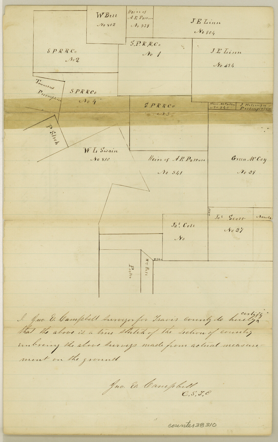
Travis County Sketch File 15
[Sketch of surveys around S. P. R.R. Co. surveys 1, 2, 3, 4 northwest from Austin]
-
Map/Doc
38310
-
Collection
General Map Collection
-
Object Dates
3/17/1869 (File Date)
-
People and Organizations
Jno. E. Campbell (Surveyor/Engineer)
-
Counties
Travis
-
Subjects
Surveying Sketch File
-
Height x Width
12.8 x 8.1 inches
32.5 x 20.6 cm
-
Medium
paper, manuscript
Part of: General Map Collection
Coryell County Sketch File 13

Print $4.00
- Digital $50.00
Coryell County Sketch File 13
1872
Size 5.0 x 8.5 inches
Map/Doc 19366

Flight Mission No. DAG-17K, Frame 119, Matagorda County

Print $20.00
- Digital $50.00
Flight Mission No. DAG-17K, Frame 119, Matagorda County
1952
Size 16.4 x 16.5 inches
Map/Doc 86339
Hardeman County Sketch File A3

Print $4.00
- Digital $50.00
Hardeman County Sketch File A3
1890
Size 14.2 x 8.8 inches
Map/Doc 25052
Motley County Sketch File 10 (N)

Print $20.00
- Digital $50.00
Motley County Sketch File 10 (N)
1900
Size 14.0 x 8.5 inches
Map/Doc 32026
Childress County Sketch File 1

Print $16.00
- Digital $50.00
Childress County Sketch File 1
1877
Size 12.8 x 8.3 inches
Map/Doc 18235
[San Antonio & Aransas Pass Ry. from Lockhart to Caldwell-Gonzales County line]
![64259, [San Antonio & Aransas Pass Ry. from Lockhart to Caldwell-Gonzales County line], General Map Collection](https://historictexasmaps.com/wmedia_w700/maps/64259.tif.jpg)
Print $40.00
- Digital $50.00
[San Antonio & Aransas Pass Ry. from Lockhart to Caldwell-Gonzales County line]
1895
Size 53.6 x 15.1 inches
Map/Doc 64259
Flight Mission No. CUG-2P, Frame 28, Kleberg County

Print $20.00
- Digital $50.00
Flight Mission No. CUG-2P, Frame 28, Kleberg County
1956
Size 18.5 x 22.2 inches
Map/Doc 86193
Flight Mission No. DQN-2K, Frame 191, Calhoun County

Print $20.00
- Digital $50.00
Flight Mission No. DQN-2K, Frame 191, Calhoun County
1953
Size 18.8 x 22.4 inches
Map/Doc 84332
Right of Way and Track Map Houston & Texas Central R.R. operated by the T. & N.O. R.R. Co., Austin Branch

Print $40.00
- Digital $50.00
Right of Way and Track Map Houston & Texas Central R.R. operated by the T. & N.O. R.R. Co., Austin Branch
1918
Size 26.0 x 57.9 inches
Map/Doc 64557
Taylor County Sketch File 17

Print $40.00
- Digital $50.00
Taylor County Sketch File 17
Size 14.5 x 17.7 inches
Map/Doc 37811
Flight Mission No. CUG-2P, Frame 85, Kleberg County

Print $20.00
- Digital $50.00
Flight Mission No. CUG-2P, Frame 85, Kleberg County
1956
Size 18.5 x 22.2 inches
Map/Doc 86217
You may also like
Roberts County Working Sketch 29

Print $20.00
- Digital $50.00
Roberts County Working Sketch 29
1983
Size 18.6 x 34.8 inches
Map/Doc 63555
Wichita County Working Sketch 19

Print $20.00
- Digital $50.00
Wichita County Working Sketch 19
1949
Size 18.1 x 30.9 inches
Map/Doc 72529
Leon County Sketch File 31

Print $20.00
- Digital $50.00
Leon County Sketch File 31
Size 19.1 x 20.5 inches
Map/Doc 11993
Kimble County Boundary File 3

Print $44.00
- Digital $50.00
Kimble County Boundary File 3
Size 9.8 x 32.4 inches
Map/Doc 64846
Jefferson County Working Sketch 24

Print $20.00
- Digital $50.00
Jefferson County Working Sketch 24
1977
Size 28.4 x 44.5 inches
Map/Doc 66567
Harris County Sketch File 109

Print $16.00
- Digital $50.00
Harris County Sketch File 109
2003
Size 11.1 x 8.7 inches
Map/Doc 78506
Leon County Working Sketch 49

Print $20.00
- Digital $50.00
Leon County Working Sketch 49
1981
Size 23.9 x 24.7 inches
Map/Doc 70448
Colorado River, Pinoak Creek Sheet

Print $6.00
- Digital $50.00
Colorado River, Pinoak Creek Sheet
1941
Size 27.5 x 35.2 inches
Map/Doc 65312
Flight Mission No. CUG-2P, Frame 82, Kleberg County

Print $20.00
- Digital $50.00
Flight Mission No. CUG-2P, Frame 82, Kleberg County
1956
Size 18.5 x 22.3 inches
Map/Doc 86214
Hudspeth County Rolled Sketch 51

Print $20.00
- Digital $50.00
Hudspeth County Rolled Sketch 51
1974
Size 19.2 x 25.7 inches
Map/Doc 6256
Galveston County NRC Article 33.136 Sketch 43

Print $59.00
- Digital $50.00
Galveston County NRC Article 33.136 Sketch 43
2002
Size 24.7 x 36.9 inches
Map/Doc 87156
Gray County Boundary File 11

Print $80.00
- Digital $50.00
Gray County Boundary File 11
Size 20.7 x 19.7 inches
Map/Doc 53912