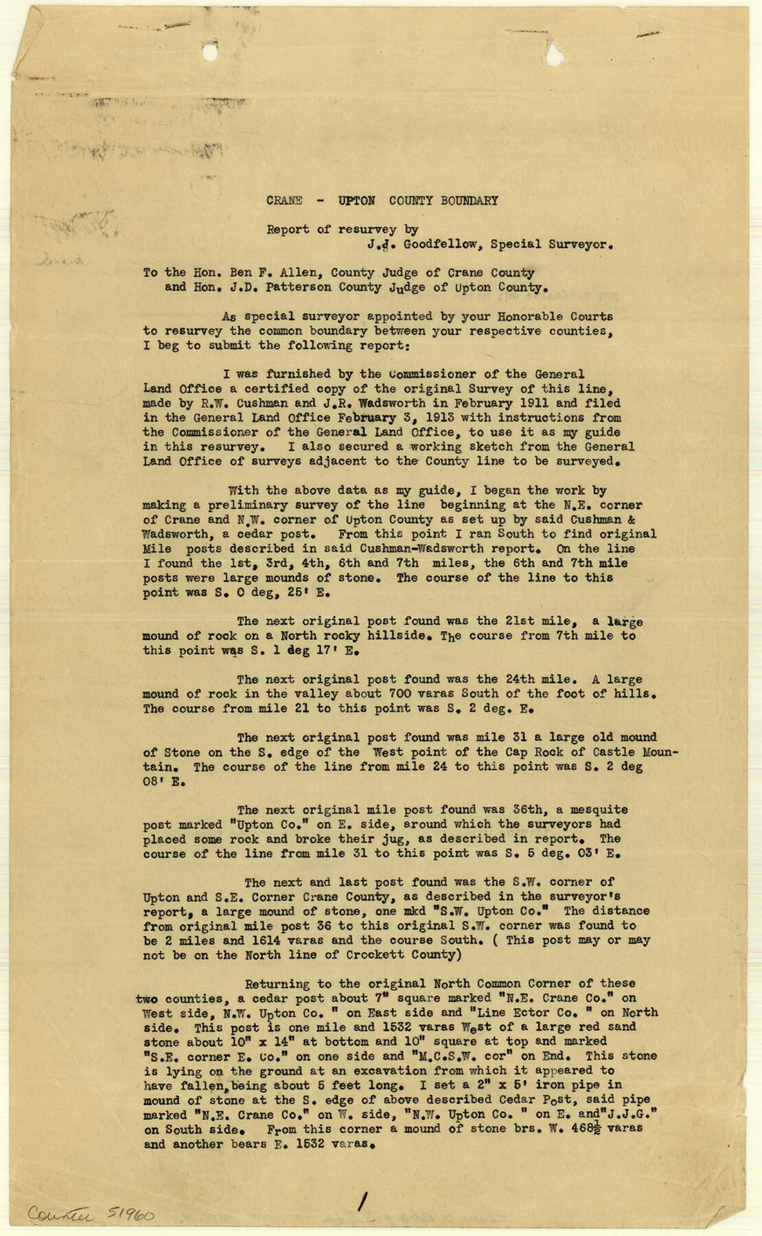
Crane County Boundary File 1a
[Surveyor's Report Crane Upton Counties Boundary Line]
-
Map/Doc
51960
-
Collection
General Map Collection
-
Counties
Crane
-
Subjects
County Boundaries
-
Height x Width
14.2 x 8.7 inches
36.1 x 22.1 cm
Part of: General Map Collection
Hunt County Sketch File 3

Print $4.00
- Digital $50.00
Hunt County Sketch File 3
1856
Size 6.0 x 8.1 inches
Map/Doc 27085
Gonzales County Rolled Sketch 3

Print $20.00
- Digital $50.00
Gonzales County Rolled Sketch 3
2021
Size 24.4 x 35.6 inches
Map/Doc 96582
Ellis County Sketch File 18a

Print $40.00
- Digital $50.00
Ellis County Sketch File 18a
Size 12.8 x 16.0 inches
Map/Doc 21864
Jefferson County Working Sketch 19

Print $20.00
- Digital $50.00
Jefferson County Working Sketch 19
1956
Size 32.2 x 24.4 inches
Map/Doc 66562

Flight Mission No. DQN-6K, Frame 69, Calhoun County

Print $20.00
- Digital $50.00
Flight Mission No. DQN-6K, Frame 69, Calhoun County
1953
Size 18.6 x 22.1 inches
Map/Doc 84441
Flight Mission No. BRA-8M, Frame 78, Jefferson County

Print $20.00
- Digital $50.00
Flight Mission No. BRA-8M, Frame 78, Jefferson County
1953
Size 15.9 x 15.8 inches
Map/Doc 85598
University Land, Block 48, Culberson County, Texas

Print $20.00
- Digital $50.00
University Land, Block 48, Culberson County, Texas
1938
Size 28.1 x 21.7 inches
Map/Doc 2411
Flight Mission No. DAH-9M, Frame 197, Orange County

Print $20.00
- Digital $50.00
Flight Mission No. DAH-9M, Frame 197, Orange County
1953
Size 18.5 x 22.4 inches
Map/Doc 86865
Pecos County Rolled Sketch 70

Print $40.00
- Digital $50.00
Pecos County Rolled Sketch 70
1929
Size 49.3 x 21.6 inches
Map/Doc 9708
Rockwall County Sketch File 8

Print $4.00
Rockwall County Sketch File 8
Size 7.1 x 10.6 inches
Map/Doc 35429
Hunt County Working Sketch 3

Print $20.00
- Digital $50.00
Hunt County Working Sketch 3
1923
Size 20.6 x 28.2 inches
Map/Doc 66350
You may also like
[Surveys in the Bexar District along the Frio River]
![315, [Surveys in the Bexar District along the Frio River], General Map Collection](https://historictexasmaps.com/wmedia_w700/maps/315.tif.jpg)
Print $2.00
- Digital $50.00
[Surveys in the Bexar District along the Frio River]
1847
Size 15.8 x 9.2 inches
Map/Doc 315
Frio County Rolled Sketch 25

Print $20.00
- Digital $50.00
Frio County Rolled Sketch 25
1965
Size 25.0 x 30.6 inches
Map/Doc 5925
[1/4 of a WWI French map of Attigny used by the 142nd Infantry for planning purposes for the Battle of Forest Ferme (farm)]
![96642, [1/4 of a WWI French map of Attigny used by the 142nd Infantry for planning purposes for the Battle of Forest Ferme (farm)], Non-GLO Digital Images](https://historictexasmaps.com/wmedia_w700/maps/96642.tif.jpg)
Print $20.00
[1/4 of a WWI French map of Attigny used by the 142nd Infantry for planning purposes for the Battle of Forest Ferme (farm)]
1918
Size 21.1 x 17.7 inches
Map/Doc 96642
Young County Working Sketch 9

Print $20.00
- Digital $50.00
Young County Working Sketch 9
1921
Size 25.9 x 36.6 inches
Map/Doc 62032
Bell County Sketch File 23

Print $4.00
- Digital $50.00
Bell County Sketch File 23
1873
Size 8.2 x 12.8 inches
Map/Doc 14414
Intracoastal Waterway - Galveston Bay to West Bay including Galveston Bay Entrance

Print $20.00
- Digital $50.00
Intracoastal Waterway - Galveston Bay to West Bay including Galveston Bay Entrance
1962
Size 26.8 x 38.4 inches
Map/Doc 69937
Childress County Working Sketch 2

Print $20.00
- Digital $50.00
Childress County Working Sketch 2
1907
Size 17.1 x 14.9 inches
Map/Doc 68018
[Sketch around I. G. Yates S.F. 12394]
![91548, [Sketch around I. G. Yates S.F. 12394], Twichell Survey Records](https://historictexasmaps.com/wmedia_w700/maps/91548-1.tif.jpg)
Print $3.00
- Digital $50.00
[Sketch around I. G. Yates S.F. 12394]
Size 17.3 x 7.2 inches
Map/Doc 91548
San Patricio County NRC Article 33.136 Location Key Sheet

Print $20.00
- Digital $50.00
San Patricio County NRC Article 33.136 Location Key Sheet
1975
Size 27.0 x 23.0 inches
Map/Doc 77035
Flight Mission No. BRE-1P, Frame 137, Nueces County

Print $20.00
- Digital $50.00
Flight Mission No. BRE-1P, Frame 137, Nueces County
1956
Size 18.7 x 22.6 inches
Map/Doc 86697
Flight Mission No. DCL-6C, Frame 66, Kenedy County

Print $20.00
- Digital $50.00
Flight Mission No. DCL-6C, Frame 66, Kenedy County
1943
Size 18.7 x 22.4 inches
Map/Doc 85908
