San Patricio County Sketch File 41
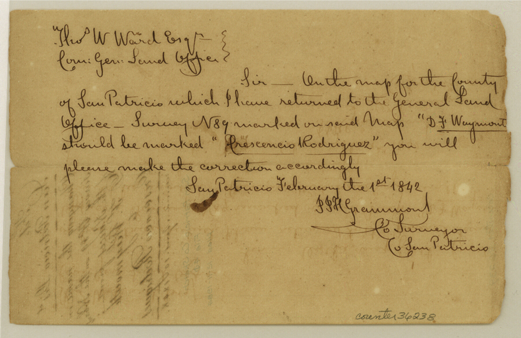
[Notice from County Surveyor noting a correction of the name associated with survey 89 on the county map delivered to the GLO]
-
Map/Doc
36238
-
Collection
General Map Collection
-
Object Dates
2/1/1842 (Creation Date)
12/11/1984 (File Date)
-
People and Organizations
J.J.H. Grammond (Surveyor/Engineer)
-
Counties
San Patricio
-
Subjects
Surveying Sketch File
-
Height x Width
5.2 x 8.0 inches
13.2 x 20.3 cm
-
Medium
paper, manuscript
Part of: General Map Collection
Coast Chart No. 210 Aransas Pass and Corpus Christi Bay with the coast to latitude 27° 12' Texas

Print $20.00
- Digital $50.00
Coast Chart No. 210 Aransas Pass and Corpus Christi Bay with the coast to latitude 27° 12' Texas
1887
Size 27.3 x 18.3 inches
Map/Doc 72803
Montgomery County Working Sketch 64

Print $20.00
- Digital $50.00
Montgomery County Working Sketch 64
1965
Size 27.9 x 33.7 inches
Map/Doc 71171
United States - Gulf Coast - From Latitude 26° 33' to the Rio Grande Texas

Print $20.00
- Digital $50.00
United States - Gulf Coast - From Latitude 26° 33' to the Rio Grande Texas
1913
Size 28.0 x 18.2 inches
Map/Doc 72833
Liberty County Sketch File 49

Print $2.00
- Digital $50.00
Liberty County Sketch File 49
1857
Size 11.8 x 8.3 inches
Map/Doc 30013
Brazos Santiago, Texas

Print $20.00
- Digital $50.00
Brazos Santiago, Texas
1900
Size 18.3 x 26.8 inches
Map/Doc 73033
Webb County Sketch File 8c

Print $4.00
- Digital $50.00
Webb County Sketch File 8c
1877
Size 12.7 x 8.2 inches
Map/Doc 39759
Edwards County Rolled Sketch 9

Print $20.00
- Digital $50.00
Edwards County Rolled Sketch 9
1885
Size 29.3 x 42.8 inches
Map/Doc 5802
Haskell County

Print $20.00
- Digital $50.00
Haskell County
1933
Size 46.4 x 39.3 inches
Map/Doc 95525
Hale County Working Sketch 7

Print $20.00
- Digital $50.00
Hale County Working Sketch 7
1963
Size 24.4 x 20.6 inches
Map/Doc 63327
Uvalde County Working Sketch 31

Print $20.00
- Digital $50.00
Uvalde County Working Sketch 31
1962
Size 28.5 x 43.0 inches
Map/Doc 72101
Bell County Sketch File 22

Print $4.00
- Digital $50.00
Bell County Sketch File 22
1872
Size 10.2 x 8.0 inches
Map/Doc 14412
Winkler County Working Sketch Graphic Index

Print $20.00
- Digital $50.00
Winkler County Working Sketch Graphic Index
1932
Size 36.4 x 36.4 inches
Map/Doc 76744
You may also like
Chambers County Rolled Sketch 11

Print $20.00
- Digital $50.00
Chambers County Rolled Sketch 11
Size 20.0 x 26.5 inches
Map/Doc 5424

La Salle County Working Sketch 27

Print $20.00
- Digital $50.00
La Salle County Working Sketch 27
1949
Size 15.2 x 23.6 inches
Map/Doc 70328
[E. T. Ry. Blk. 1]
![89794, [E. T. Ry. Blk. 1], Twichell Survey Records](https://historictexasmaps.com/wmedia_w700/maps/89794-1.tif.jpg)
Print $40.00
- Digital $50.00
[E. T. Ry. Blk. 1]
Size 56.5 x 43.4 inches
Map/Doc 89794
Hockley County

Print $20.00
- Digital $50.00
Hockley County
1897
Size 19.1 x 20.5 inches
Map/Doc 3675
East Part of Edwards County

Print $20.00
- Digital $50.00
East Part of Edwards County
1975
Size 39.7 x 28.5 inches
Map/Doc 77270
[Sketch showing unsurveyed land in West Texas as of 1902]
![89937, [Sketch showing unsurveyed land in West Texas as of 1902], Twichell Survey Records](https://historictexasmaps.com/wmedia_w700/maps/89937-1.tif.jpg)
Print $20.00
- Digital $50.00
[Sketch showing unsurveyed land in West Texas as of 1902]
Size 42.0 x 34.0 inches
Map/Doc 89937
Greer County Sketch File 7

Print $40.00
- Digital $50.00
Greer County Sketch File 7
Size 12.8 x 17.5 inches
Map/Doc 24526
Angelina County Sketch File 11c

Print $7.00
- Digital $50.00
Angelina County Sketch File 11c
Size 11.1 x 6.0 inches
Map/Doc 12946
Brewster County Rolled Sketch 131

Print $20.00
- Digital $50.00
Brewster County Rolled Sketch 131
1975
Size 30.0 x 32.3 inches
Map/Doc 8522
Bee County Working Sketch 4

Print $20.00
- Digital $50.00
Bee County Working Sketch 4
1930
Size 18.5 x 16.5 inches
Map/Doc 67254
Starr County Sketch File 1

Print $4.00
- Digital $50.00
Starr County Sketch File 1
Size 10.3 x 5.1 inches
Map/Doc 36854