Jefferson County Sketch File 2
[Sketch of surveys near mouth of Neches River]
-
Map/Doc
28090
-
Collection
General Map Collection
-
Object Dates
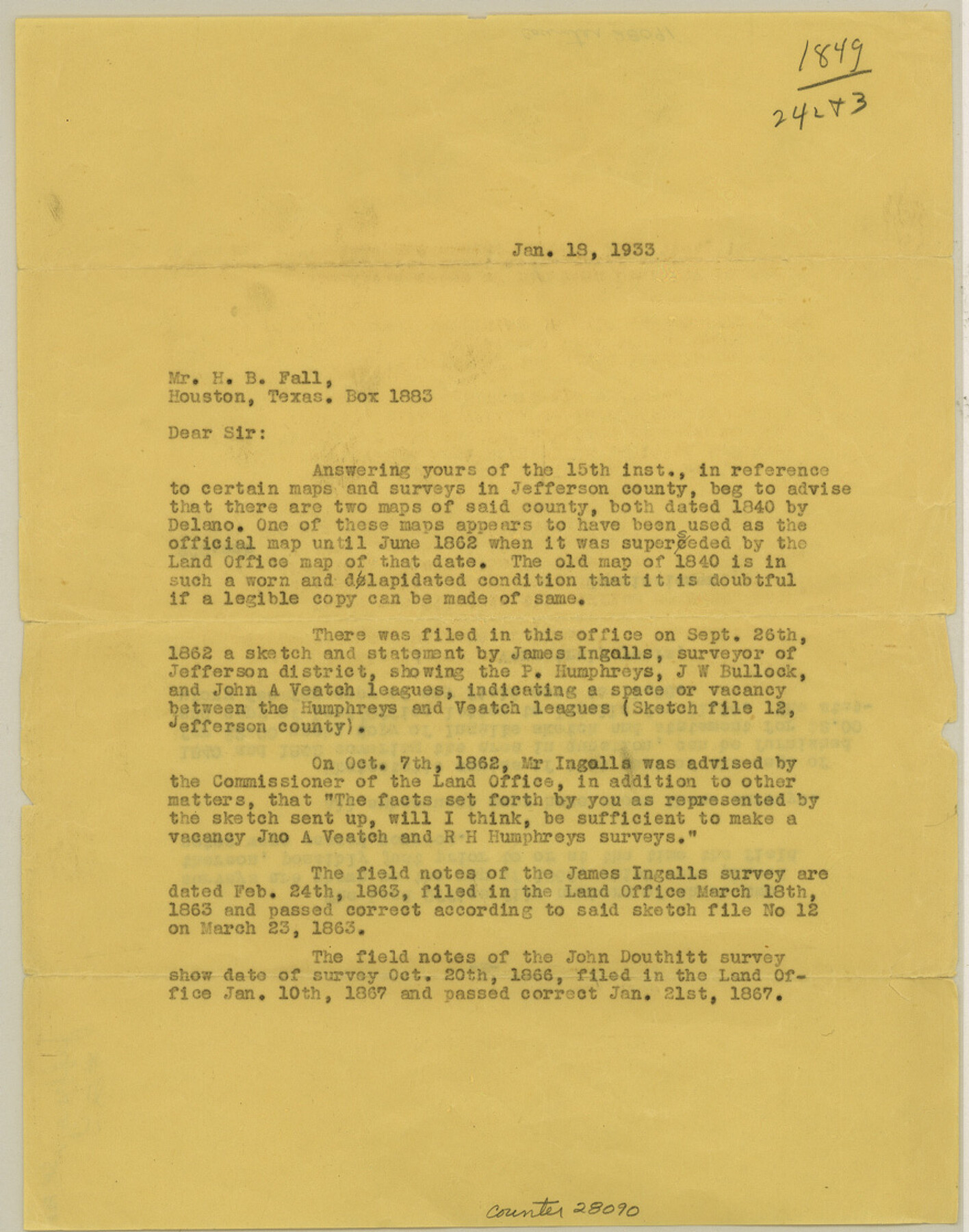
1/18/1933 (Correspondence Date)
9/26/1862 (File Date)
2/24/1863 (Survey Date)
3/18/1863 (File Date)
10/20/1866 (Survey Date)
1/10/1867 (File Date)
-
People and Organizations
James Ingalls (Surveyor/Engineer)
Chas. W. Pressler (Draftsman)
-
Counties
Jefferson
-
Subjects
Surveying Sketch File
-
Height x Width
11.2 x 8.8 inches
28.5 x 22.4 cm
-
Medium
paper, print
-
Features
Chambers Bluff
Part of: General Map Collection
Angelina County Rolled Sketch 1

Print $20.00
- Digital $50.00
Angelina County Rolled Sketch 1
Size 30.4 x 29.6 inches
Map/Doc 77184
San Jacinto County Working Sketch 30

Print $20.00
- Digital $50.00
San Jacinto County Working Sketch 30
Size 18.2 x 24.4 inches
Map/Doc 63743
Presidio County Working Sketch 7

Print $20.00
- Digital $50.00
Presidio County Working Sketch 7
1926
Size 35.0 x 40.0 inches
Map/Doc 71681
Zapata County Working Sketch 8

Print $20.00
- Digital $50.00
Zapata County Working Sketch 8
1949
Size 25.3 x 23.1 inches
Map/Doc 62059
Floyd County Sketch File 20

Print $4.00
- Digital $50.00
Floyd County Sketch File 20
1914
Size 14.5 x 8.9 inches
Map/Doc 22772
Reeves County

Print $20.00
- Digital $50.00
Reeves County
1915
Size 46.5 x 35.7 inches
Map/Doc 16797
Hall County Sketch File 13

Print $20.00
- Digital $50.00
Hall County Sketch File 13
Size 15.7 x 24.2 inches
Map/Doc 11606
Real County Working Sketch 60

Print $40.00
- Digital $50.00
Real County Working Sketch 60
1963
Size 60.4 x 41.1 inches
Map/Doc 71952
Flight Mission No. CRC-3R, Frame 210, Chambers County

Print $20.00
- Digital $50.00
Flight Mission No. CRC-3R, Frame 210, Chambers County
1956
Size 18.6 x 22.3 inches
Map/Doc 84865
Howard County Working Sketch 1

Print $20.00
- Digital $50.00
Howard County Working Sketch 1
1941
Size 19.7 x 25.1 inches
Map/Doc 66267
Bee County Sketch File 33

Print $56.00
- Digital $50.00
Bee County Sketch File 33
Size 11.3 x 8.9 inches
Map/Doc 14349
Terrell County Rolled Sketch 39

Print $20.00
- Digital $50.00
Terrell County Rolled Sketch 39
1941
Size 18.7 x 42.9 inches
Map/Doc 7943
You may also like
Val Verde County Working Sketch 117

Print $20.00
- Digital $50.00
Val Verde County Working Sketch 117
1993
Size 20.8 x 36.8 inches
Map/Doc 82845
Flight Mission No. BRE-1P, Frame 33, Nueces County

Print $20.00
- Digital $50.00
Flight Mission No. BRE-1P, Frame 33, Nueces County
1956
Size 18.5 x 22.2 inches
Map/Doc 86629
Newton County Rolled Sketch 17

Print $20.00
- Digital $50.00
Newton County Rolled Sketch 17
1955
Size 34.5 x 47.1 inches
Map/Doc 6847
Atascosa County Sketch File 2b

Print $6.00
- Digital $50.00
Atascosa County Sketch File 2b
1855
Size 8.8 x 13.2 inches
Map/Doc 13728
Hardeman County Working Sketch 2

Print $20.00
- Digital $50.00
Hardeman County Working Sketch 2
1900
Size 19.1 x 19.4 inches
Map/Doc 63383

Map of Mexico, including Yucatan & Upper California, exhibiting the chief cities and towns, the principal travelling routes &c.

Print $20.00
- Digital $50.00
Map of Mexico, including Yucatan & Upper California, exhibiting the chief cities and towns, the principal travelling routes &c.
1847
Size 33.5 x 24.7 inches
Map/Doc 93936
Red River County Working Sketch 42

Print $20.00
- Digital $50.00
Red River County Working Sketch 42
1968
Size 28.7 x 36.8 inches
Map/Doc 72025
Leon County Rolled Sketch 14

Print $20.00
- Digital $50.00
Leon County Rolled Sketch 14
1976
Size 33.4 x 27.9 inches
Map/Doc 9432
Presidio County Sketch File 74

Print $8.00
- Digital $50.00
Presidio County Sketch File 74
1946
Size 11.4 x 8.8 inches
Map/Doc 34687

Hamilton County

Print $20.00
- Digital $50.00
Hamilton County
1916
Size 42.3 x 43.2 inches
Map/Doc 66850