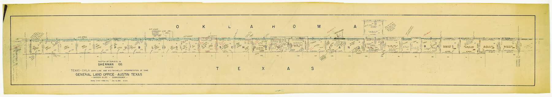
Sherman County Rolled Sketch 12
Sketch of surveys in Sherman Co. showing Texas-Okla bdry. line and W.D. Twichell's interpretation of same
-
Map/Doc
10611
-
Collection
General Map Collection
-
Object Dates
1/6/1951 (Creation Date)
1/26/1951 (File Date)
-
People and Organizations
W.D. Twichell (Surveyor/Engineer)
-
Counties
Sherman
-
Subjects
Surveying Rolled Sketch
-
Height x Width
63.9 x 11.3 inches
162.3 x 28.7 cm
-
Medium
blueprint/diazo
-
Scale
1" = 1000 varas
Part of: General Map Collection
Stephens County Sketch File 6

Print $4.00
- Digital $50.00
Stephens County Sketch File 6
Size 9.1 x 9.1 inches
Map/Doc 37021
Colorado River, LaGrange Sheet

Print $20.00
- Digital $50.00
Colorado River, LaGrange Sheet
1934
Size 37.8 x 32.9 inches
Map/Doc 65302
Cooke County Sketch File 44

Print $20.00
- Digital $50.00
Cooke County Sketch File 44
1928
Size 20.4 x 20.6 inches
Map/Doc 11178
Guadalupe County Sketch File 7

Print $20.00
- Digital $50.00
Guadalupe County Sketch File 7
Size 15.6 x 19.5 inches
Map/Doc 11590
Crockett County Working Sketch 4

Print $40.00
- Digital $50.00
Crockett County Working Sketch 4
Size 26.8 x 70.4 inches
Map/Doc 68337
Flight Mission No. DQN-2K, Frame 39, Calhoun County

Print $20.00
- Digital $50.00
Flight Mission No. DQN-2K, Frame 39, Calhoun County
1953
Size 18.2 x 22.2 inches
Map/Doc 84244
Victoria County Working Sketch 9

Print $40.00
- Digital $50.00
Victoria County Working Sketch 9
1963
Size 49.9 x 35.8 inches
Map/Doc 72279
Maps of Gulf Intracoastal Waterway, Texas - Sabine River to the Rio Grande and connecting waterways including ship channels

Print $20.00
- Digital $50.00
Maps of Gulf Intracoastal Waterway, Texas - Sabine River to the Rio Grande and connecting waterways including ship channels
1966
Size 14.6 x 22.2 inches
Map/Doc 61975
Liberty County Working Sketch 52

Print $20.00
- Digital $50.00
Liberty County Working Sketch 52
1956
Size 32.5 x 24.6 inches
Map/Doc 70512
Harris County Rolled Sketch WHW2

Print $20.00
- Digital $50.00
Harris County Rolled Sketch WHW2
Size 15.5 x 14.4 inches
Map/Doc 6148
Culberson County Sketch File 20

Print $57.00
- Digital $50.00
Culberson County Sketch File 20
Size 10.2 x 15.6 inches
Map/Doc 20205
Harris County Sketch File 80a

Print $20.00
- Digital $50.00
Harris County Sketch File 80a
1892
Size 27.8 x 17.6 inches
Map/Doc 11667
You may also like
Leon County Sketch File 34

Print $10.00
- Digital $50.00
Leon County Sketch File 34
1962
Size 11.1 x 8.7 inches
Map/Doc 94787
Taylor County Sketch File 9

Print $40.00
- Digital $50.00
Taylor County Sketch File 9
Size 14.6 x 15.8 inches
Map/Doc 37792
Kerr County Working Sketch 23

Print $20.00
- Digital $50.00
Kerr County Working Sketch 23
1966
Size 33.4 x 41.0 inches
Map/Doc 70054
Map of the Rio Grande & Eagle Pass Ry. from Sections 7-13 Inclusive, Webb County

Print $40.00
- Digital $50.00
Map of the Rio Grande & Eagle Pass Ry. from Sections 7-13 Inclusive, Webb County
1909
Size 25.6 x 55.5 inches
Map/Doc 64656
Jones County Sketch File 8

Print $20.00
- Digital $50.00
Jones County Sketch File 8
Size 18.5 x 22.8 inches
Map/Doc 11898
Montgomery County Sketch File 28

Print $22.00
- Digital $50.00
Montgomery County Sketch File 28
Size 14.1 x 8.7 inches
Map/Doc 31873
Callahan County

Print $20.00
- Digital $50.00
Callahan County
1918
Size 44.6 x 40.2 inches
Map/Doc 4900
Flight Mission No. CGI-1N, Frame 182, Cameron County

Print $20.00
- Digital $50.00
Flight Mission No. CGI-1N, Frame 182, Cameron County
1955
Size 18.6 x 22.3 inches
Map/Doc 84517

Jeff Davis Co.

Print $20.00
- Digital $50.00
Jeff Davis Co.
1915
Size 26.0 x 28.0 inches
Map/Doc 92174
Sketch showing the Connnecting Lines run by Olliver Hedgcoxe for the Texan Emigration and Land Company connecting their Surveys made by them in Peters' Colony, Texas

Print $40.00
- Digital $50.00
Sketch showing the Connnecting Lines run by Olliver Hedgcoxe for the Texan Emigration and Land Company connecting their Surveys made by them in Peters' Colony, Texas
1854
Size 45.8 x 61.9 inches
Map/Doc 1969
McMullen County Sketch File 22

Print $4.00
- Digital $50.00
McMullen County Sketch File 22
Size 10.0 x 8.1 inches
Map/Doc 31377