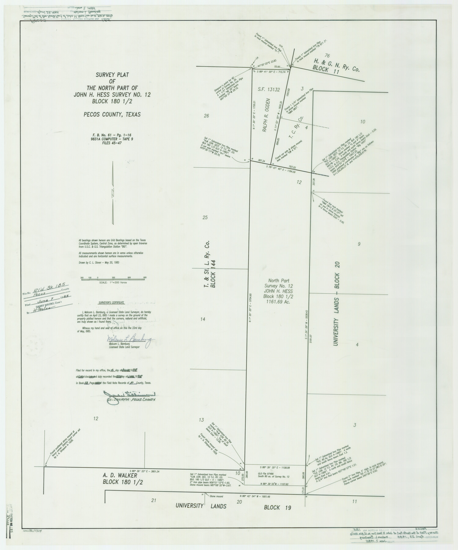
Pecos County Rolled Sketch 185
Survey plat of the north part of John H. Hess survey no. 12, Block 180 1/2, Pecos County, Texas
-
Map/Doc
7304
-
Collection
General Map Collection
-
Object Dates
1985/4/23 (Creation Date)
1985/6/7 (File Date)
-
People and Organizations
Malcom L. Bamburg (Surveyor/Engineer)
-
Counties
Pecos
-
Subjects
Surveying Rolled Sketch
-
Height x Width
34.9 x 29.0 inches
88.6 x 73.7 cm
-
Medium
mylar, print
Part of: General Map Collection
Leon County Boundary File 1

Print $34.00
- Digital $50.00
Leon County Boundary File 1
Size 21.0 x 6.6 inches
Map/Doc 56281
Map of Caldwell County

Print $20.00
- Digital $50.00
Map of Caldwell County
1871
Size 17.2 x 19.8 inches
Map/Doc 3357
Atascosa County Working Sketch 10

Print $20.00
- Digital $50.00
Atascosa County Working Sketch 10
1919
Size 26.2 x 22.3 inches
Map/Doc 67206
Hays County Rolled Sketch 22

Print $20.00
- Digital $50.00
Hays County Rolled Sketch 22
1924
Size 19.4 x 20.6 inches
Map/Doc 6178
Right of Way and Track Map, Galveston, Harrisburg & San Antonio Ry. operated by the T. & N. O. R.R. Co., Victoria Division, Rosenberg to Beeville

Print $40.00
- Digital $50.00
Right of Way and Track Map, Galveston, Harrisburg & San Antonio Ry. operated by the T. & N. O. R.R. Co., Victoria Division, Rosenberg to Beeville
1918
Size 24.4 x 57.9 inches
Map/Doc 76158
Val Verde County Working Sketch 99

Print $20.00
- Digital $50.00
Val Verde County Working Sketch 99
1981
Size 17.2 x 22.6 inches
Map/Doc 72234
Blanco County Working Sketch 29

Print $40.00
- Digital $50.00
Blanco County Working Sketch 29
1969
Size 52.4 x 33.4 inches
Map/Doc 67389
[Right of Way and Track Map, the Missouri, Kansas and Texas Ry. of Texas - Henrietta Division]
![64766, [Right of Way and Track Map, the Missouri, Kansas and Texas Ry. of Texas - Henrietta Division], General Map Collection](https://historictexasmaps.com/wmedia_w700/maps/64766.tif.jpg)
Print $20.00
- Digital $50.00
[Right of Way and Track Map, the Missouri, Kansas and Texas Ry. of Texas - Henrietta Division]
1918
Size 11.8 x 26.9 inches
Map/Doc 64766
Crosby County Rolled Sketch R

Print $20.00
- Digital $50.00
Crosby County Rolled Sketch R
1926
Size 41.2 x 40.0 inches
Map/Doc 8740
Flight Mission No. DAG-21K, Frame 108, Matagorda County

Print $20.00
- Digital $50.00
Flight Mission No. DAG-21K, Frame 108, Matagorda County
1952
Size 18.7 x 22.3 inches
Map/Doc 86436
Potter County Rolled Sketch 6

Print $20.00
- Digital $50.00
Potter County Rolled Sketch 6
Size 26.3 x 35.0 inches
Map/Doc 7320
San Jacinto County Rolled Sketch 8

Print $20.00
- Digital $50.00
San Jacinto County Rolled Sketch 8
1940
Size 33.6 x 35.1 inches
Map/Doc 7559
You may also like
Flight Mission No. BRA-16M, Frame 94, Jefferson County

Print $20.00
- Digital $50.00
Flight Mission No. BRA-16M, Frame 94, Jefferson County
1953
Size 18.5 x 22.1 inches
Map/Doc 85706
Goliad County Sketch File 20

Print $38.00
- Digital $50.00
Goliad County Sketch File 20
1887
Size 8.8 x 12.3 inches
Map/Doc 24265
Matagorda County Sketch File 6

Print $4.00
- Digital $50.00
Matagorda County Sketch File 6
Size 8.0 x 4.9 inches
Map/Doc 30738
Lampasas County Boundary File 5

Print $16.00
- Digital $50.00
Lampasas County Boundary File 5
Size 11.1 x 8.7 inches
Map/Doc 56128
J. De Cordova's Map of the State of Texas Compiled from the records of the General Land Office of the State

Print $20.00
- Digital $50.00
J. De Cordova's Map of the State of Texas Compiled from the records of the General Land Office of the State
1849
Size 36.0 x 34.0 inches
Map/Doc 93930
Fractional Township No. 10 South Range No. 27 East of the Indian Meridian, Indian Territory

Print $20.00
- Digital $50.00
Fractional Township No. 10 South Range No. 27 East of the Indian Meridian, Indian Territory
1897
Size 19.2 x 24.3 inches
Map/Doc 75246
Hemphill County Working Sketch 38

Print $20.00
- Digital $50.00
Hemphill County Working Sketch 38
1982
Size 29.9 x 27.8 inches
Map/Doc 66133
[Surveys between the Sabine and Red Rivers made for titles under Radford Berry, Commissioner]
![14, [Surveys between the Sabine and Red Rivers made for titles under Radford Berry, Commissioner], General Map Collection](https://historictexasmaps.com/wmedia_w700/maps/14.tif.jpg)
Print $20.00
- Digital $50.00
[Surveys between the Sabine and Red Rivers made for titles under Radford Berry, Commissioner]
1835
Size 22.3 x 15.9 inches
Map/Doc 14
[Surveying Sketch of Mrs. S. C. Alexander, Vicente Salines, J. P. Blessington, et al in Sutton County, Texas]
![75765, [Surveying Sketch of Mrs. S. C. Alexander, Vicente Salines, J. P. Blessington, et al in Sutton County, Texas], Maddox Collection](https://historictexasmaps.com/wmedia_w700/maps/75765.tif.jpg)
Print $20.00
- Digital $50.00
[Surveying Sketch of Mrs. S. C. Alexander, Vicente Salines, J. P. Blessington, et al in Sutton County, Texas]
Size 19.3 x 21.0 inches
Map/Doc 75765
Denton County Rolled Sketch 4

Print $20.00
- Digital $50.00
Denton County Rolled Sketch 4
1973
Size 22.7 x 39.3 inches
Map/Doc 5701
Navigation Maps of Gulf Intracoastal Waterway, Port Arthur to Brownsville, Texas

Print $4.00
- Digital $50.00
Navigation Maps of Gulf Intracoastal Waterway, Port Arthur to Brownsville, Texas
1951
Size 16.6 x 21.6 inches
Map/Doc 65429
Culberson County Rolled Sketch 30

Print $84.00
- Digital $50.00
Culberson County Rolled Sketch 30
1928
Size 57.1 x 36.1 inches
Map/Doc 8746