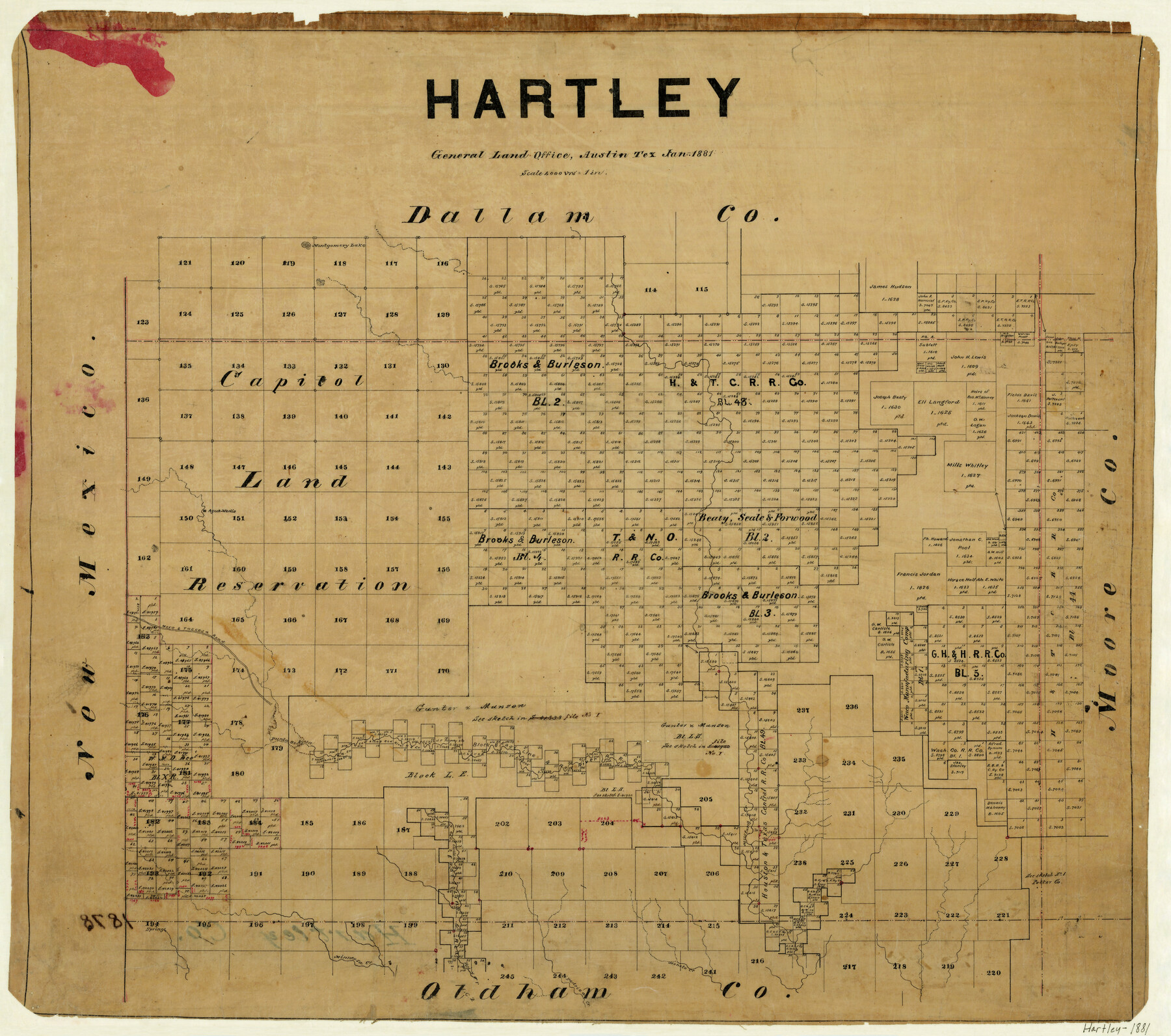
Hartley
-
Map/Doc
3640
-
Collection
General Map Collection
-
Object Dates
1/1881 (Creation Date)
-
Counties
Hartley
-
Subjects
County
-
Height x Width
25.4 x 28.4 inches
64.5 x 72.1 cm
-
Features
Montgomery Lake
Agua Medio
Agua Medio River
Moro and Tascosa Road
Punta de Agua River
Punta de Agua Creek
Agua Medio Creek
IRR
Mustang Creek
EL&RR
Minneosa Creek
Pedriza Creek
Moneto Creek
Romero Creek
Part of: General Map Collection
Flight Mission No. CRE-1R, Frame 133, Jackson County

Print $20.00
- Digital $50.00
Flight Mission No. CRE-1R, Frame 133, Jackson County
1956
Size 16.2 x 16.2 inches
Map/Doc 85341
United States - Gulf Coast - From Latitude 26° 33' to the Rio Grande Texas

Print $20.00
- Digital $50.00
United States - Gulf Coast - From Latitude 26° 33' to the Rio Grande Texas
1913
Size 18.4 x 27.9 inches
Map/Doc 72842
University Land Field Notes for Blocks K, L, M, and N in Hudspeth County

University Land Field Notes for Blocks K, L, M, and N in Hudspeth County
Map/Doc 81713
Palo Pinto County Sketch File 7

Print $4.00
- Digital $50.00
Palo Pinto County Sketch File 7
1870
Size 13.0 x 8.2 inches
Map/Doc 33398
Young County Working Sketch 18

Print $20.00
- Digital $50.00
Young County Working Sketch 18
1960
Size 23.9 x 29.2 inches
Map/Doc 62041
Harris County Sketch File 14

Print $20.00
- Digital $50.00
Harris County Sketch File 14
Size 17.4 x 18.4 inches
Map/Doc 11649
Map of Newton County

Print $40.00
- Digital $50.00
Map of Newton County
1894
Size 69.8 x 28.4 inches
Map/Doc 82078
Guadalupe County Sketch File 7c

Print $22.00
- Digital $50.00
Guadalupe County Sketch File 7c
Size 12.7 x 15.5 inches
Map/Doc 24672
Map of Jasper County Republic of Texas

Print $20.00
- Digital $50.00
Map of Jasper County Republic of Texas
1841
Size 36.1 x 30.0 inches
Map/Doc 3712
Edwards County Boundary File 29

Print $22.00
- Digital $50.00
Edwards County Boundary File 29
Size 15.4 x 31.0 inches
Map/Doc 65502
Kimble County Sketch File 8

Print $14.00
- Digital $50.00
Kimble County Sketch File 8
1847
Size 7.7 x 7.0 inches
Map/Doc 28920
Webb County Working Sketch 72

Print $20.00
- Digital $50.00
Webb County Working Sketch 72
1974
Size 22.1 x 38.2 inches
Map/Doc 72439
You may also like
[Sketch of expeditions, trails in Jones, Taylor, Shackelford, Callahan, Buchanan/Stephens and Eastland Counties]
![65406, [Sketch of expeditions, trails in Jones, Taylor, Shackelford, Callahan, Buchanan/Stephens and Eastland Counties], General Map Collection](https://historictexasmaps.com/wmedia_w700/maps/65406.tif.jpg)
Print $4.00
- Digital $50.00
[Sketch of expeditions, trails in Jones, Taylor, Shackelford, Callahan, Buchanan/Stephens and Eastland Counties]
1873
Size 10.7 x 18.1 inches
Map/Doc 65406
Flight Mission No. DAG-24K, Frame 159, Matagorda County

Print $20.00
- Digital $50.00
Flight Mission No. DAG-24K, Frame 159, Matagorda County
1953
Size 17.2 x 19.1 inches
Map/Doc 86573
General Highway Map, Burnet County, Texas

Print $20.00
General Highway Map, Burnet County, Texas
1961
Size 18.2 x 24.5 inches
Map/Doc 79393
College Park Addition to the City of Lubbock Located on Section 9, Block B

Print $20.00
- Digital $50.00
College Park Addition to the City of Lubbock Located on Section 9, Block B
Size 12.9 x 15.9 inches
Map/Doc 92277
San Augustine County Working Sketch 1

Print $3.00
- Digital $50.00
San Augustine County Working Sketch 1
1906
Size 9.1 x 11.3 inches
Map/Doc 63688
Briscoe County Working Sketch 2

Print $20.00
- Digital $50.00
Briscoe County Working Sketch 2
1913
Size 25.4 x 23.9 inches
Map/Doc 67805
[Missouri, Kansas & Texas Line Map through Bastrop County]
![64031, [Missouri, Kansas & Texas Line Map through Bastrop County], General Map Collection](https://historictexasmaps.com/wmedia_w700/maps/64031.tif.jpg)
Print $40.00
- Digital $50.00
[Missouri, Kansas & Texas Line Map through Bastrop County]
1916
Size 26.5 x 124.4 inches
Map/Doc 64031
Runnels County Working Sketch 4

Print $20.00
- Digital $50.00
Runnels County Working Sketch 4
1906
Size 15.1 x 19.3 inches
Map/Doc 63600
Copy of Surveyor's Field Book, Morris Browning - In Blocks 7, 5 & 4, I&GNRRCo., Hutchinson and Carson Counties, Texas

Print $2.00
- Digital $50.00
Copy of Surveyor's Field Book, Morris Browning - In Blocks 7, 5 & 4, I&GNRRCo., Hutchinson and Carson Counties, Texas
1888
Size 6.9 x 8.8 inches
Map/Doc 62281
Scurry County Working Sketch 6

Print $20.00
- Digital $50.00
Scurry County Working Sketch 6
1950
Size 38.7 x 37.3 inches
Map/Doc 63835
Hunt County Working Sketch 5

Print $20.00
- Digital $50.00
Hunt County Working Sketch 5
1942
Size 23.8 x 20.2 inches
Map/Doc 66352
Map of east part of West Bay & SW part of Galveston Bay, Galveston County showing subdivision for mineral development

Print $40.00
- Digital $50.00
Map of east part of West Bay & SW part of Galveston Bay, Galveston County showing subdivision for mineral development
1963
Size 64.1 x 45.4 inches
Map/Doc 3079