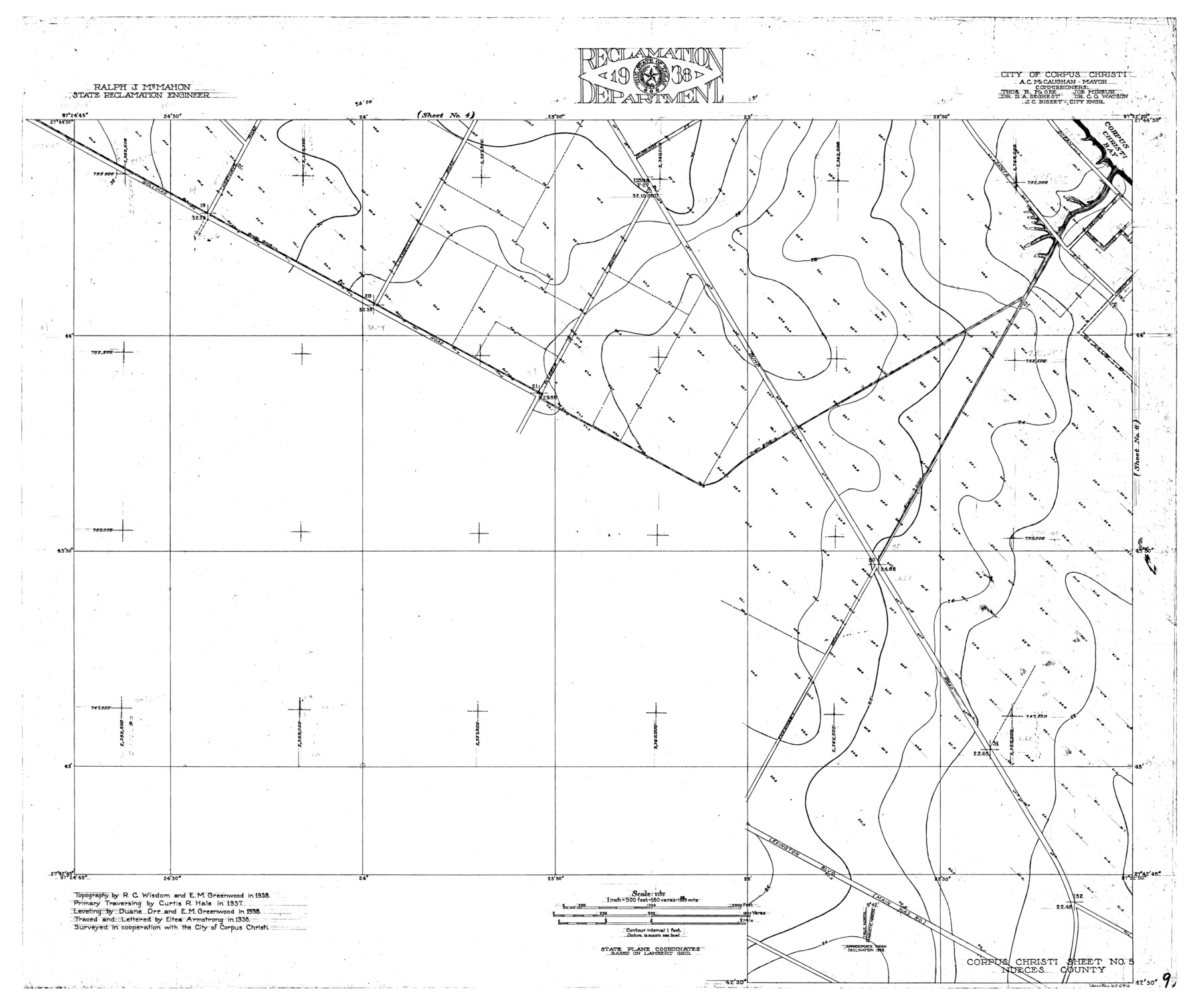
Nueces River, Corpus Christi Sheet No. 5
- 
                          Map/Doc
65094
 - 
                            Collection
General Map Collection
 - 
                            Object Dates
1938 (Creation Date)
 - 
                            People and Organizations
Texas State Reclamation Department (Publisher)
Eltea Armstrong (Draftsman)
Eltea Armstrong (Compiler)
Duane Orr (Surveyor/Engineer)
Curtis R. Hale (Surveyor/Engineer)
R.C. Wisdom (Surveyor/Engineer)
E.M. Greenwood (Surveyor/Engineer)
 - 
                            Counties
Nueces
 - 
                            Subjects
City River Surveys Topographic
 - 
                            Height x Width
28.4 x 33.7 inches
72.1 x 85.6 cm
 - 
                            Comments
Corpus Christi Sheet No. 5 located west of the Corpus Christi Sheet No. 6 and south of the Corpus Christi Sheet No. 4.
 
Part of: General Map Collection
            Ward County Rolled Sketch 20


                                            Print $20.00                    
                                             -                         Digital $50.00                                    
                Ward County Rolled Sketch 20
1950
Size 27.4 x 22.7 inches
                                Map/Doc 8162
            
            San Patricio County Working Sketch 4


                                            Print $20.00                    
                                             -                         Digital $50.00                                    
                San Patricio County Working Sketch 4
1924
Size 20.8 x 23.6 inches
                                Map/Doc 63766
            
            Flight Mission No. DIX-7P, Frame 88, Aransas County


                                            Print $20.00                    
                                             -                         Digital $50.00                                    
                Flight Mission No. DIX-7P, Frame 88, Aransas County
1956
Size 18.7 x 22.3 inches
                                Map/Doc 83882
            
            St. Louis, Brownsville & Mexico Railway Location Map from Mile 80 to Mile 100


                                            Print $40.00                    
                                             -                         Digital $50.00                                    
                St. Louis, Brownsville & Mexico Railway Location Map from Mile 80 to Mile 100
1905
Size 19.5 x 64.6 inches
                                Map/Doc 64166
            
            Matagorda County NRC Article 33.136 Sketch 2


                                            Print $26.00                    
                                             -                         Digital $50.00                                    
                Matagorda County NRC Article 33.136 Sketch 2
2005
Size 22.1 x 34.8 inches
                                Map/Doc 83395
            
            Flight Mission No. BRE-1P, Frame 51, Nueces County


                                            Print $20.00                    
                                             -                         Digital $50.00                                    
                Flight Mission No. BRE-1P, Frame 51, Nueces County
1956
Size 18.3 x 22.2 inches
                                Map/Doc 86640
            
            Map of Jasper County


                                            Print $20.00                    
                                             -                         Digital $50.00                                    
                Map of Jasper County
1839
Size 41.6 x 28.5 inches
                                Map/Doc 3711
            
            Shackelford County Boundary File 5


                                            Print $14.00                    
                                             -                         Digital $50.00                                    
                Shackelford County Boundary File 5
Size 8.6 x 14.0 inches
                                Map/Doc 58661
            
            Gaines County Rolled Sketch 12


                                            Print $20.00                    
                                             -                         Digital $50.00                                    
                Gaines County Rolled Sketch 12
1940
Size 26.4 x 33.5 inches
                                Map/Doc 5933
            
            Flight Mission No. DQO-7K, Frame 103, Galveston County


                                            Print $20.00                    
                                             -                         Digital $50.00                                    
                Flight Mission No. DQO-7K, Frame 103, Galveston County
1952
Size 18.5 x 22.7 inches
                                Map/Doc 85118
            
            Central America Past and Present


            Central America Past and Present
1986
Size 20.6 x 31.6 inches
                                Map/Doc 96839
            You may also like
            Matagorda County Sketch File 14


                                            Print $40.00                    
                                             -                         Digital $50.00                                    
                Matagorda County Sketch File 14
Size 13.5 x 14.8 inches
                                Map/Doc 30772
            
            Map of Red River Division of International & Great Northern Railroad


                                            Print $40.00                    
                                             -                         Digital $50.00                                    
                Map of Red River Division of International & Great Northern Railroad
Size 23.5 x 103.4 inches
                                Map/Doc 64475
            
            Fractional Township No. 10 South Range No. 10 East of the Indian Meridian, Indian Territory


                                            Print $20.00                    
                                             -                         Digital $50.00                                    
                Fractional Township No. 10 South Range No. 10 East of the Indian Meridian, Indian Territory
1898
Size 19.3 x 24.3 inches
                                Map/Doc 75218
            
            Flight Mission No. DCL-7C, Frame 7, Kenedy County


                                            Print $20.00                    
                                             -                         Digital $50.00                                    
                Flight Mission No. DCL-7C, Frame 7, Kenedy County
1943
Size 15.3 x 15.2 inches
                                Map/Doc 85999
            
            Hudspeth County Working Sketch 19


                                            Print $20.00                    
                                             -                         Digital $50.00                                    
                Hudspeth County Working Sketch 19
1959
Size 21.5 x 24.3 inches
                                Map/Doc 66301
            
            The Mexican Municipalities. On the Eve of Texas Independence, 1836


                                            Print $20.00                    
                                    
                The Mexican Municipalities. On the Eve of Texas Independence, 1836
2020
Size 17.2 x 21.6 inches
                                Map/Doc 96013
            
            Harris County Working Sketch 103


                                            Print $20.00                    
                                             -                         Digital $50.00                                    
                Harris County Working Sketch 103
1980
Size 18.6 x 16.8 inches
                                Map/Doc 65995
            
            [Unknown Building Sketch]


                                            Print $20.00                    
                                             -                         Digital $50.00                                    
                [Unknown Building Sketch]
Size 17.1 x 22.6 inches
                                Map/Doc 75794
            
            Eastland County


                                            Print $20.00                    
                                             -                         Digital $50.00                                    
                Eastland County
1945
Size 41.8 x 42.0 inches
                                Map/Doc 77268
            
            Flight Mission No. DIX-5P, Frame 103, Aransas County


                                            Print $20.00                    
                                             -                         Digital $50.00                                    
                Flight Mission No. DIX-5P, Frame 103, Aransas County
1956
Size 17.5 x 18.2 inches
                                Map/Doc 83781
            
            Webb County Sketch File 23


                                            Print $20.00                    
                                             -                         Digital $50.00                                    
                Webb County Sketch File 23
1923
Size 25.4 x 16.3 inches
                                Map/Doc 12638
            
            Map of Galveston Bay from Lawrence Cove to Stevenson's Station


                                            Print $20.00                    
                                             -                         Digital $50.00                                    
                Map of Galveston Bay from Lawrence Cove to Stevenson's Station
1851
Size 41.5 x 30.0 inches
                                Map/Doc 69922