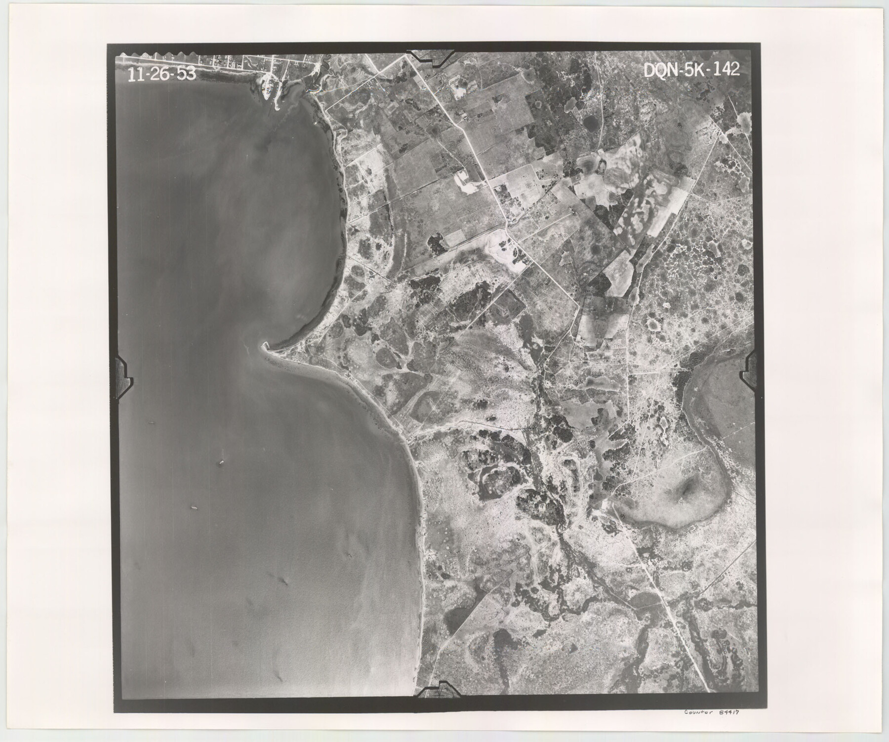
Flight Mission No. DQN-5K, Frame 142, Calhoun County
DQN-5K-142
-
Map/Doc
84417
-
Collection
General Map Collection
-
Object Dates
1953/11/26 (Creation Date)
-
People and Organizations
U. S. Department of Agriculture (Publisher)
-
Counties
Calhoun
-
Subjects
Aerial Photograph
-
Height x Width
18.5 x 22.1 inches
47.0 x 56.1 cm
-
Comments
Flown by Aero Exploration Company of Tulsa, Oklahoma.
Part of: General Map Collection
Comal County Boundary File 1

Print $5.00
- Digital $50.00
Comal County Boundary File 1
Size 12.9 x 11.0 inches
Map/Doc 51776
Shelby County Rolled Sketch 17

Print $20.00
- Digital $50.00
Shelby County Rolled Sketch 17
1975
Size 34.6 x 26.4 inches
Map/Doc 7783
![3295, [Bell County], General Map Collection](https://historictexasmaps.com/wmedia_w700/maps/3295-1.tif.jpg)
Map of Floyd County

Print $20.00
- Digital $50.00
Map of Floyd County
1888
Size 25.4 x 19.6 inches
Map/Doc 3547
Current Miscellaneous File 102

Print $611.00
- Digital $50.00
Current Miscellaneous File 102
Size 11.5 x 7.1 inches
Map/Doc 74379
Cooke County Rolled Sketch 4

Print $20.00
- Digital $50.00
Cooke County Rolled Sketch 4
Size 18.1 x 23.1 inches
Map/Doc 5562
Calhoun County NRC Article 33.136 Sketch 8

Print $28.00
- Digital $50.00
Calhoun County NRC Article 33.136 Sketch 8
2019
Size 17.9 x 23.8 inches
Map/Doc 95371
Sterling County Working Sketch 11

Print $20.00
- Digital $50.00
Sterling County Working Sketch 11
1987
Size 20.1 x 40.8 inches
Map/Doc 63993
Brazos County Sketch File 2

Print $4.00
- Digital $50.00
Brazos County Sketch File 2
1858
Size 7.9 x 9.4 inches
Map/Doc 15552
Flight Mission No. CGI-1N, Frame 141, Cameron County

Print $20.00
- Digital $50.00
Flight Mission No. CGI-1N, Frame 141, Cameron County
1955
Size 18.5 x 22.2 inches
Map/Doc 84497
Reagan County Sketch File 14

Print $6.00
- Digital $50.00
Reagan County Sketch File 14
Size 11.3 x 8.8 inches
Map/Doc 34993
Map of Wilson County

Print $20.00
- Digital $50.00
Map of Wilson County
1879
Size 23.0 x 24.4 inches
Map/Doc 4157
You may also like
[Block H, E. L. & R. R. Block C-41, and Public School Lands]
![91386, [Block H, E. L. & R. R. Block C-41, and Public School Lands], Twichell Survey Records](https://historictexasmaps.com/wmedia_w700/maps/91386-1.tif.jpg)
Print $20.00
- Digital $50.00
[Block H, E. L. & R. R. Block C-41, and Public School Lands]
1951
Size 24.5 x 18.4 inches
Map/Doc 91386
Parker County Working Sketch 16

Print $20.00
- Digital $50.00
Parker County Working Sketch 16
1990
Map/Doc 71466
Kimble County Working Sketch 71

Print $20.00
- Digital $50.00
Kimble County Working Sketch 71
1965
Size 47.1 x 22.0 inches
Map/Doc 70139
Harris County Rolled Sketch WB

Print $20.00
- Digital $50.00
Harris County Rolled Sketch WB
Size 15.0 x 28.5 inches
Map/Doc 6146
[Block B&, and Adjacent Leagues]
![91432, [Block B&, and Adjacent Leagues], Twichell Survey Records](https://historictexasmaps.com/wmedia_w700/maps/91432-1.tif.jpg)
Print $20.00
- Digital $50.00
[Block B&, and Adjacent Leagues]
Size 30.7 x 29.6 inches
Map/Doc 91432
[Right of Way & Track Map, The Texas & Pacific Ry. Co. Main Line]
![64675, [Right of Way & Track Map, The Texas & Pacific Ry. Co. Main Line], General Map Collection](https://historictexasmaps.com/wmedia_w700/maps/64675.tif.jpg)
Print $20.00
- Digital $50.00
[Right of Way & Track Map, The Texas & Pacific Ry. Co. Main Line]
Size 11.0 x 18.4 inches
Map/Doc 64675
Gillespie County Rolled Sketch 9

Print $20.00
- Digital $50.00
Gillespie County Rolled Sketch 9
2014
Size 23.6 x 36.2 inches
Map/Doc 93713
Rusk County Sketch File 19

Print $4.00
Rusk County Sketch File 19
Size 13.0 x 8.2 inches
Map/Doc 35526
McMullen County Working Sketch 31

Print $20.00
- Digital $50.00
McMullen County Working Sketch 31
1957
Size 39.9 x 25.9 inches
Map/Doc 70732
Navarro County Sketch File 9

Print $2.00
- Digital $50.00
Navarro County Sketch File 9
Size 8.3 x 9.1 inches
Map/Doc 32317
Thomas Kelly Subdivision in Parmer and Castro Counties, Texas

Print $20.00
- Digital $50.00
Thomas Kelly Subdivision in Parmer and Castro Counties, Texas
1906
Size 20.4 x 16.6 inches
Map/Doc 92549
Flight Mission No. CGI-3N, Frame 160, Cameron County

Print $20.00
- Digital $50.00
Flight Mission No. CGI-3N, Frame 160, Cameron County
1954
Size 18.5 x 22.3 inches
Map/Doc 84624